


EVEN after Greater New York was founded in 1905, southern Brooklyn and much of Queens, Bronx and Staten Island was farmland if not open country, dotted here and there with small towns. It wasn’t till the 1910s that an overall street grid was mapped in Queens and southern Brooklyn, and not till the 1950s that the grid was built out with residential and business districts. Even in the Super 70s, when I visited southern Staten Island and places in Brooklyn such as Bergen Beach there were large swaths of unbuilt-on territory. By now, that’s all changed.
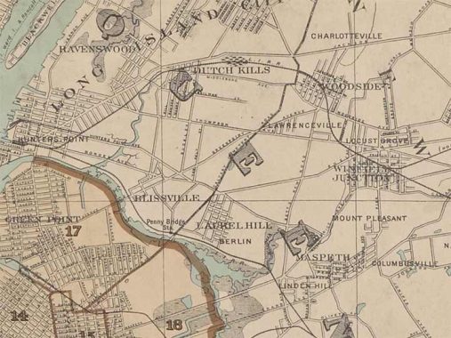
Sometimes it’s frustrating to look at older NYC street maps because they often reflected developers’ plans instead of what was actually in existence. This 1905 map Gravesend historian Joseph Ditta referred me to is different as it shows only the roads that were actually there. I have excerpted the portion that shows much of Greenpoint as well as western Queens.
What strikes me right off the bat are names of small towns since absorbed into larger neighborhoods, such as Berlin, once a haven for German immigrants, along 56th Road and Rust Street and the Long Island Rail Road. Today most dwellings have been excised and the area is mostly warehousing and light manufacturing.
Linden Hill was once the west end of Maspeth, located where the Montauk and Bushwick LIRR branches had a junction. Older maps that this show the area as “Malvina.” Meanwhile, Laurel Hill was north of 56th Road and east of today’s Brooklyn-Queens Expressway; its legacy is Linden Hill Boulevard, the BQE service road. A separate Linden Hill was a small subsection of Ridgewood and is remembered by Linden Hill Cemetery.
While today Woodside is fairly vast, it had subdivisions in 1905 such as Lawrenceville, Locust Grove and Winfield, possibly named for General Winfield Scott (but I remain unsure).
Midway between Woodside and Maspeth along Fisk Avenue (named for a casketmaker and now called 69th Street) was Mount Pleasant. Now known as Ridgewood Heights after a later real estate development, it’s indeed a hilly area. Further east, where Maspeth blends into Middle Village, was Columbusville and Nassau Heights. Long before the Jackson Heights area was developed into a premier residential area, it was called Charlottesville (and earlier, Trains Meadow).
Newtown, of course, is the best known of these lost towns; it didn’t disappear, but was renamed by developer Cord Meyer as Elmhurst. Early British colonists in Maspeth were chased out by angry Native Americans, and eventually moved further east, where Queens Boulevard meets Broadway today. Eventually, the name Newtown was applied to the, er, new town. By the mid-1800s, horse cars and eventually streetcars began to bring in people from all over, and when Meyer developed the area in the 1890s, he lobbied for a “higher class” name…Elmhurst. Strangely, the IND subway, which arrived in 1936, keeps the Newtown name at a station, and Newtown High School retains the old moniker, as do a pair of roads in Astoria that were formerly main thoroughfares leading to the town.
More lost neighborhoods of Brooklyn and Queens
As always, “comment…as you see fit.” I earn a small payment when you click on any ad on the site. Take a look at the new JOBS link in the red toolbar at the top of the page on the desktop version, as I also get a small payment when you view a job via that link.
11/25/24