
I seem to return to the lost neighborhood of Laurel Hill, Queens, time and again. I think whoever lives and works there call it West Maspeth these days. It’s a fairly small, self-contained area, mostly industrial, with a few scattered homes here and there that were built just after the area’s last farms closed down. It’s the kind of area that you bundle people off to for interrogations or worse, maybe the place that John Randolph was taken to be surgically altered to look like Rock Hudson in the sinister 1966 thriller Seconds. In short, it’s not an area you go to if you don’t have to.

What was Laurel Hill, and is now West Maspeth, is located in the area bordered by Calvary Cemetery/Brooklyn-Queens Expressway in the west; the Queens-Midtown Expressway (Long Island expressway) on the north; 58th Street in the east; and 56th Road/Long Island Rail Road tracks on the south.
In the post-colonial era Laurel Hill was a farm owned by Edward Waters, whose name was affixed to one of the streets laid out in it later; Waters Avenue was later renamed 54th Road. Waters sold the farm to Jacob Rapelye, who built a large mansion at 55th Drive and 46th Street that was torn down long ago (the intersection has been eliminated, as it is now part of a UPS Customer Service complex). The South Side Railroad arrived in 1890. Its trackage is now part of the freight-only Long Island Rail Road Montauk Branch. The proximity of the railroad attracted industry to the region with the Phelps-Dodge copper refining plant along Newtown Creek opening in 1920 and remaining in business until 1983. Its deposits into the Creek have long outlasted it. F. Haberman’s National Enameling and Stamping Company was so busy its own LIRR stop was constructed that outlasted the company, closing in 1998.


While Laurel Hill/West Maspeth has mostly been taken over by industry, including a derrick construction company that has left some streets overshadowed by huge cranes, it was once fairly populous; gradually, though, its residents have deserted it, leaving a few scattered homes here and there. A number of homes were purchased and then torn down to make was for construction of the New Kosciuszko Bridge.
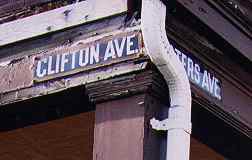
The building seen in the above Gallery, at 54th Road and 46th Street, once carried a couple of enamel signs with the former names of the streets, Clifton and Waters Avenues. The signs were removed by the early 2000s.
My connection to 54th Road is that it’s the former headquarters of Hagstrom Maps, and I had the second of my two interviews there for map researcher there in 1992. (My first was on West 33rd in Manhattan in 1981!) I think my lack of a drivers’ license skunked me in each case, although the job paid little either time I interviewed.
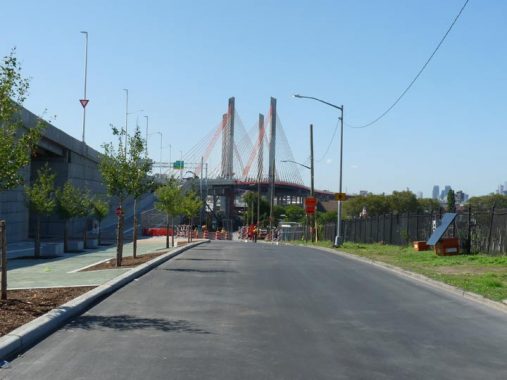
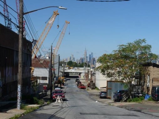
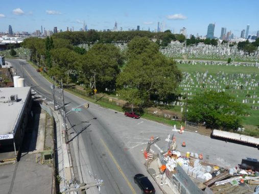
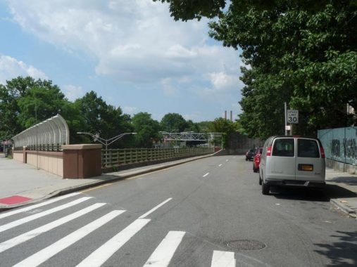
More recently, 54th Road has become my main route in Queens to get to the New Kosciuszko Bridge (let’s just call it New K and Old K, shall we?) bicycle/pedestrian path, a feature that was removed from the Old K shortly after it opened in 1939 in favor of an additional traffic lane. The road we see here is Laurel Hill Boulevard, which is really what I want to talk about today; the pedestrian ramp is on the left.
Google Street View has a feature that allows you to look back several years, in some cases all the way back to 2007 when GSV was inaugurated. Interestingly if you go back to 2017 at the same spot on Laurel Hill Boulevard, you can see the deconstructed Old K Bridge awaiting final passage to the scrap heap. The New K is seen in the distance at right.
Laurel Hill Boulevard
Today most Queens residents don’t think about Laurel Hill Boulevard that much; if they notice it at all, they think of it as the Brooklyn-Queens Expressway service road. However, it’s one of Queens’ oldest roads and additionally, one of Queens’ oldest paved roads. Currently, the road runs in two separate sections…

Traveling east on the Queens Midtown on I-495, there’s a direct exit onto Laurel Hill Boulevard. This is the section that runs along the east side of old Calvary Cemetery one-way southbound only, ending at Review Avenue at the former Penny Bridge LIRR station. It has gained in importance with the opening of the New K, as it also contains a pedestrian-bike lane that’s connected to Sunnyside, north of the QME, via a new concrete overpass. East of here is the huge spaghetti interchange where the I-495 meets the I-278.
The second section runs along the BQE, for the most part, between 46th and 67th Streets. The Department of Transportation is quite lax in identifying it; the road along the south side of the BQE is labeled Laurel Hill Boulevard by street signs beginning at 46th Street, while the road along the north side is identified as the Brooklyn-Queens Expressway at least as far east as 47th. There are no signs at all at the important intersection with 48th Street.
Between 48th and 58th, the road completely ducks under the BQE as it runs through New Calvary Cemetery, resuming north and south service roads at 58th. Beginning there, the DOT definitively calls both of them Laurel Hill Boulevard.


Before looking at Laurel Hill Boulevard today, let’s take a look at the past for a bit. I have mentioned it’s one of Queens’ older roads. I have outlined it in red on this 1852 Dripps map of western Queens County. This route still exists largely intact today but is mostly overlain by the Brooklyn-Queens Expressway. If you zoom in near Calvary, you can see the old Edward Waters property (left).
In 1840, engineers constructed a new road from Penny Bridge on the Creek to Newtown (today’s Elmhurst) built with the finest pavement available at the time: crushed oyster shells. Today, its route is still definable by Laurel Hill Boulevard, the Brooklyn-Queens Expressway, and 45th Avenue. Today, Laurel Hill Blvd. functions mainly as the BQE service road, though it breaks free at its western end at Calvary Cemetery and also for a few blocks at its eastern end in Woodside (see below). Coney Island, Brooklyn has kept its own ancient Shell Road.
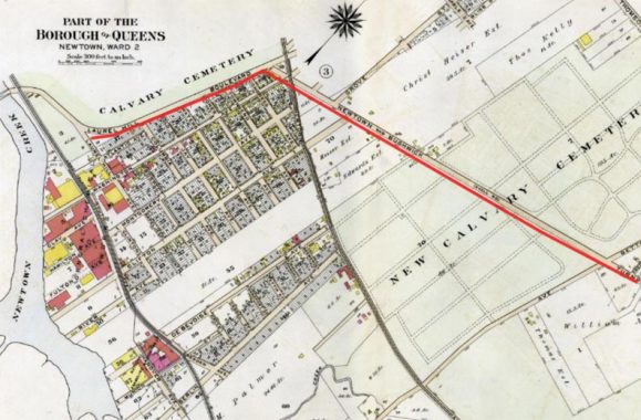
By 1909, the road had been tabbed Laurel Hill Boulevard in the southern section running along Old Calvary. The section running northeast through New Calvary was named the Newtown and Bushwick Turnpike, and the old Shell Road name had been suppressed. I am unsure if the road was a turnpike and accepted tolls (along other tolled routes, a large log, or pike, was turned when the toll was paid).
Newtown and Bushwick Turnpike? Indeed. Wagons and carts, and later autos, could cross into Brooklyn via various Newtown Creek bridges called Penny Bridge because of the toll taken. The last Penny Bridge, a metal truss bridge spanning the creek, was demolished in 1939 after the Old K Bridge opened.

By 1929 much of southern Sunnyside had been built up, and the road had been definitively named Laurel Hill Boulevard, though maps still had the old Bushwick-Newtown Turnpike name, as area oldtimers remembered it that way. Note the “X” formed by Laurel Hill Boulevard and Borden Avenue, which today is amid the spaghetti tangle where I-495 and I-278 meet.
Forgotten NY correspondent Sergey Kadinsky:
Laurel Hill Memorial Park was a traffic triangle formed by Borden Avenue, Laurel Hill Boulevard and 42nd Street, a block to the south of the grid-defiant Celtic Avenue. On September 14, 1930, a memorial flagstaff was was dedicated at this park. It was a perfectly-designed traffic triangle at a crossroads dating back at least to the mid-19th century. This park was eliminated in favor of the massive interchange of BQE and LIE in the 1940s. The boxy memorial flagpole base was then relocated to nearby Triangle 54 in Blissville. In contrast to its initial site, the flagpole’s present location has no benches, shrubs, or decorative fence. It is surrounded by industry with few visitors to appreciate the meaning of this memorial.
One more Laurel Hill Blvd tidbit. That triangular park used to belong to a gravestone manufacturer, as seen on the 1914 Sanborn map. The really cool item here is that Celtic Avenue was part of the ancient Bowery Bay Road, the border between Newtown and Long Island City, which ran north to Bowery Bay.
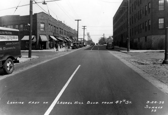
Laurel Hill Boulevard, looking east at 47th Street, in March 1938. Next year, work would begin on the first incarnation of the elevated Brooklyn-Queens Expressway, which would be built here; the buildings on the left side of the street would be demolished. Here’s a view from 1939 showing the elevated BQE being built above Laurel Hill Blvd at Calvary Cemetery.

This is the same scene, on a recent Google Street View image. We’re not in exactly the same position as in 1938, though, as the northern section of Laurel Hill Boulevard is a little bit north of where it was in 1938. In other words, in 1938, we’d be on 47th Street looking at the west side of the apartment building on the left. Because of this, the private home seen here on 47th Street may well have been there in 1938, to the left of where the camera was situated there.
The NYC Municipal Archives provides more photos of this stretch of Laurel Hill Boulevard in 1940.


A look at the gateway to New Calvary Cemetery on the south side of Laurel Hill Boulevard, just east of 48th Street, in 1938 and in 2019. At this point these sections of Calvary Cemetery are no longer “new,” but they were established more recently than the westernmost section was, in 1848. The original Calvary had been expanded to its present size in 1867 by purchasing surrounding property. Even then, before the great bridges were built to Manhattan and before it was part of Greater New York, Queens’ Catholic population was growing and Calvary trustees agreed that it was necessary to purchase more acreage for Calvary. This was done by acquiring several farms between 1871 and 1885, when the Cemetery reached its present size; these last acquisitions, located on land running from (today’s) Queens Boulevard south to 55th Avenue and from about 48th Street east to 58th Street, are known collectively as New Calvary Cemetery. Over three million people are interred in all of the Calvary cemeteries, which means the deceased population of Queens exceeds its living.

As I’ve mentioned Laurel Hill Boulevard once again sees sunlight at 58th Street; east of here, it again acts as the north-south service road for the BQE. Some interesting (to me at least) dwarf Deskey (and other makes and models) lampposts mark this stretch of the road.

At 60th Street, this is the south side of Laurel Hill Boulevard as most people know it, never guessing that it has a history that reaches back to 1840.
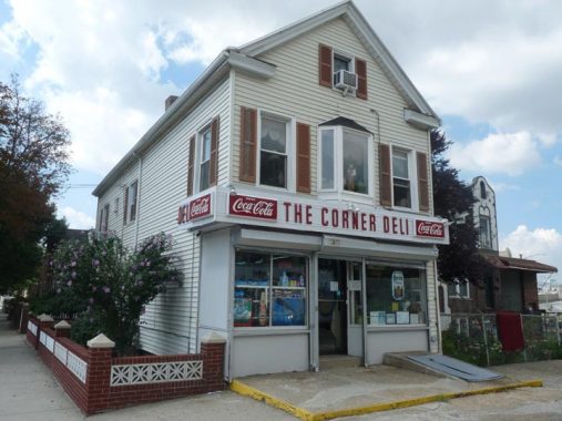
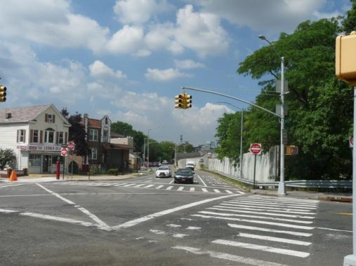
#65-24 Laurel Hill Boulevard at 65th Place, the Corner Deli, is one of the few buildings on the south side of the BQE that have survived over the decades; here’s the way it looked in 1940. Then, as now, it’s a grocery store. In the front is what’s called a “privilege sign”; oroginally, Coca-Cola or some other sponsor would foot the bill for the sign provided ads for the product were located on the sign. This is a particularly handsome example in red and white. Other such signs are most commonly in green and gold.
Seen from 65th Place, this is the eastern end of the Laurel Hill Boulevard service road on the north side of the BQE. Traffic is one-way westbound. East of 65th Place, the BQE descends into an open trench and splits in two as it empties its traffic into the Grand Central Parkway, which admits commercial vehicles bound for the Triboro Bridge.
Meanwhile this is the east end of the south Laurel Hill Boulevard service lane at 65th Place. At this point, the Boulevard finishes its eastbound business with the BQE, but LHB is not quite ended…
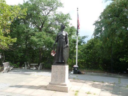
The Winfield War Memorial


Winfield was a small town in Queens, now absorbed by its larger neighbor, Woodside. It was developed by entrepreneurs G.G. Andrews and J.F. Kendall in 1854 and named for General Winfield Scott, who fought in the War of 1812; the Black Hawk War; carried out the command of his commander-in-chief Andrew Jackson and relocated the Cherokees in the incident known as the “Trail of Tears”; commanded U.S. forces in the Mexican War; ran for President under the Whig banner in 1852, losing to Franklin Pierce; and returned to the military when the Civil War broke out, living long enough to see the Union victory. Scott had moved into a townhouse on West 12th Street in New York City in 1853, and was a New Yorker when the small development in Queens was given his name.
The war memorial was crafted by Italian sculptor James Novelli (1865-1940) and honors seven soldiers from Winfield who perished in World War I. Dedicated in 1926, it depicts an allegorical representation of Victory wearing a laurel crown and carrying a sword in her right hand and a shield on her left. On the marble stele she stands upon is carven the names of the seven Winfield heroes.
When the memorial was constructed, 65th Place and Laurel Hill Boulevard was a moderately-traveled city crossroads, but the Brooklyn-Queens Expressway was constructed along Laurel Hill Boulevard in the late 1950s and the memorial was then at a very busy corner, as there is an expressway exit nearby. It was hit by cars numerous times and was decapitated in 1989. All the while, it was also attacked by air pollution and graffiti vandals.
Finally, the memorial was hit full-on by an auto in 2001 and knocked onto the expressway, which necessitated a 10-year absence from the corner while the Parks Department once again rebuilt it and reinstalled it in 2011. Today, it is well-protected by traffic bollards.
Sculptor Novelli’s other works include, according to NYC Parks, the Saratoga Park War Memorial (1921; stolen and destroyed in 2000) in Brooklyn, the bronze mausoleum doors in Calvary Cemetery (1923) for which he won the Henry O. Avery Prize for sculpture, and the Clason Point War Memorial in the Bronx. Sadly, when his career suffered during the Depression, Novelli was a suicide.


We’re not quite done with Laurel Hill Boulevard. There’s a two-block stretch between 65th Place and 67th Street independent of the BQE, and the block between 66th and 67th Streets actually has residences and buildings on both sides, instead of an elevated expressway one one side. This represents the only stretch of the Bushwick-Newtown Turnpike, or Shell Road, in the section of it called Laurel Hill Boulevard that can make that claim.


Today Laurel Hill Boulevard ends with a green triangle planted by Parks at 67th Street; one lane continues on to join Queens Boulevard at the NY Connecting Railroad overpass.
That’s the eastern end of Laurel Hill Boulevard: but not the eastern end of the Bushwick-Newtown Turnpike, a.k.a. Shell Road. East of the Connecting Railroad, the old route continues east from Queens Boulevard at 70th Street, all the way east to the Moore Homestead Playground at Broadway. That section is now part of 45th Avenue, and FNY covered it on this page. There are a number of old homes and anomalies on it that mark it as an old route.
Check out the ForgottenBook, take a look at the gift shop, and as always, “comment…as you see fit.”
8/9/20
15 comments
In 1998 or 1999, when I made my one and now of course only trip on the Lower Montauk into LIC, narrow gauge industrial tracks were still visible on the old Phelps Dodge site.
21 years later, they’re still there and still visible on the waterfront…one place they haven’t tried yet to eliminate the site’s industrial past
https://www.google.com/maps/place/Laurel+Hill+Blvd,+Queens,+NY/@40.725651,-73.9264876,69m/data=!3m1!1e3!4m5!3m4!1s0x89c25ec6646605d9:0x5907db6d17a69776!8m2!3d40.7357801!4d-73.9146388
A very hot spot for street racing in its day.
A small detail as to the western-most end of Laurel Hill Boulevard that might otherwise get overlooked. From the Penny Bridge, the original alignment of the road went straight in a northeasterly direction. When the cemetery was expanded, the road made a sweeping curve to the east, to where it now exists immediately adjacent to the Brooklyn-Queens Expressway. The original alignment continues to exist as a cemetery road, “Calvary Avenue,” separating older cemetery sections 4 and 6 from newer cemetery sections 4-B and 6B. This original alignment is clearly visible in aerial photographs.
Meanwhile, there is a noticeable bend in Borden Avenue, opposite 40th Street. There’s a similar bend in the parallel cemetery road immediately south of Borden Avenue. This is where Hunterspoint Avenue had previously intersected Borden Avenue, and where Borden Avenue turned, and followed what would be the prolongation of Hunterspoint Avenue eastward of the intersection. Thus, the original intersection of Borden Avenue and Lauren Hill Boulevard can be approximated by prolonging Hunterspoint Avenue and this bent portion of Borden Avenue, along with prolonging the cemetery road that had originally been the alignment of Laurel Hill Boulevard.
In your picture from 47th street, you say that buildings on both sides of Laurel Hill Blvd were demolished but this is not true. The large apartment building on the right is still there. In fact, I believe the overhead photo of the construction of the BQE was taken from the corner of the roof of said building. You can see the tip of the parapet in the bottom of the picture. I thought it was a wing at first but that would be too low to be a plane. Thanks!
You are correct. I forgot to look at the south service road. I have amended the text.
Not only are the street name markers no longer attached to the building at the corner of 54th Road & 46th Street, but the original building itself seems to have met its fate circa 2011.
I lived across from Moore park as a HS student(Newtown)worked in what was the EMS HQ on 58st(while testing the sprinkler system 30 years ago an old timer told us when he was a boy there was a pond there)I am aware of that stretch of Borden Ave going to 58st that’s where I met Robin Williams filmin I later worked for DSNY as a steam FITTER in all their facilities as a steam FITTER I still live on 40st and have walked all over that area and over the new bridge down to greenpoint then back up Greenpoint ave through Blisville up to Sunnyside GREAT ARTICLE
RETIRED;
The title of the film was “Cadillac Man”
https://www.bing.com/images/search?view=detailV2&ccid=3tS3NQa4&id=50E4BA4BECD0BD7CA2CA9BB8421968E3F4B26023&thid=OIP.3tS3NQa4nwZJi2mPiSV1QwHaLI&mediaurl=https%3a%2f%2fcdn.shopify.com%2fs%2ffiles%2f1%2f1416%2f8662%2fproducts%2fCadillac_Man_1990_original_film_art_600x.jpg%3fv%3d1562802723&exph=902&expw=600&q=cadillac+man+filming+location&simid=607992387938222224&ck=B85D1887C21FB3C007C38A579AFF7E31&selectedIndex=0&qpvt=cadillac+man+filming+location&FORM=IRPRST&ajaxhist=0
If I’m not mistaken, the Corner Deli used to be an IGA Store and there was a Pitney Bowes store front on 67 th street between Queens Bl. and Laurel Hill Bl. about where the Dialysis place is now. Was the infamous Mets Motel there at the end of Laurel Hill by 67th and Queens Bl?
I grew up in the area in the ’60s. The IGA was located at the corner of 65th St and LH Blvd. Used to stop there on the way home from school for a 10 cent can of soda. The Mets Motel was on Queens Blvd. at 73rd St. I attended nearby St.Mary’s Help Of Christians School. Not sure about Pitney Bowes-I don’t remember that. Maybe that was later on. I recall ABC Pre-school daycare (which is still there according to Google maps).
My father grew up in Woodside in the 1920’s. He told me that the family would walk from their row house on
47th Street and 50th Avenue to St. Raphael’s on Greenpoint Avenue for Sunday Mass. They would walk along
the trolley tracks and Laurel Hill Blvd. as the other roads were still unpaved.
In the early 1960s when I was a toddler I vaguely remember being taken
for walks by my Grandma over a pedestrian overpass connecting the north and south sides of Laurel Hill Boulevard near 59th Place or 60th Street.
The BQE was still under construction in the early 1960s; I seem to
remember it dividing 59th Place north and south for the first time around
1964 or so when I was knee-high to a grasshopper. Can anyone confirm
this?
Is that where The Godfather, Don Corleone himself, is buried?!
My maternal grandmother used to tell of walking with her father and sisters from Ainslie Street in Williamsburg to Calvary to visit their father’s family grave. They’d walk over the Penny Bridge for free, my G-grandfather was a detective in the Brooklyn Police Department never paid, and gain entry to Calvary on Laurel Hill. They’d walk up the hill past Calvary Park which is a NYC park honoring the members of the “Fighting 69th” Regiment that was comprised of mostly Irish soldiers. They’d bring a picnic basket with them and have a lunch at the grave.
My great-great-grandmother bought the plot in 1865 as her husband was dying. She chose the site because it was high on a hill, closer to Jesus, and had a wonderful view of the soon to be polluted Newtown Creek and Brooklyn’s North Side. My g-g-g-grandmother, g-g-grandmother, g-g-grandfather, g-grandmother, g-grandfather and a slew of aunts and uncles are also interred there. I visit the grave several times a year and also visit the grave of my paternal g-g-g-grandfather, g-g-g-granmother, g-g-grandmother and g-g-grandfather who are buried about a hundred yards away from the maternal side of the family.
Somehow, I do miss the whirring sound of tires coming from the old Kosciusko Bridge.
BTW, Calvary Park is a mess. The Parks Department was supposed to rehab the site but nothing has been done over the past decade. A shame.