Fordham, a bustling shopping district in center-west Bronx, was named for a small settlement along the Harlem River begun in 1669 but later devastated by the Revolutionary War. Belmont takes its name from tobacco magnate Jacob Lorillard’s estate; the Lorillards owned nearly all of what would become The Bronx Zoo, the NY Botanical Garden, and the neighborhoods of Belmont, Bronx Park South and Norwood. Even the late Bronx historian John McNamara is unclear about the name’s origins, but going back to its old English derivation, “ford+ham” is a meadow or small settlement (ham) beside a waterway shallow enough to be waded, or forded, across. Might the Harlem River be shallow there, or ever were?
Belmont is famous for its own Little Italy centered along Arthur Avenue, with its panoply of small mom and pop shops purveying delicacies, and small, intimate restaurants. Oddly enough I have never partaken of the panoply of comestibles found here, since I’m always on my own and don’t prefer to eat alone in proper restaurants. One of these days.
GOOGLE MAP: FORDHAM-BELMONT WALK
I decided on a February walk from Fordham, meandering east into Belmont and finally to West Farms, from whence the Q44 bus back to Flushing, Queens could be obtained. It’s an odd yoking of two very different NYC neighborhoods on that bus route that uses the Whitestone Bridge. Anyway, I got a train I rarely take, the #4 local over the Woodlawn El on Jerome Avenue and getting off at Burnside Avenue, named for a Civil War general with healthy side whiskers. It’s one of the few Jerome el stations with a center platform; this line disdains express service except when some of the tracks are being repaired.
Always been a fan of the apartment house on the corner with that molded cupola, a mecca for graffiti birds.

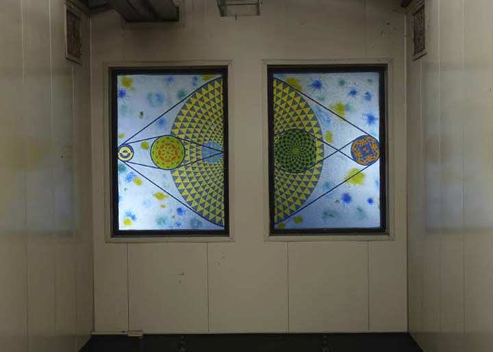
Like many stations Burnside Avenue has been tricked out with relatively new artwork over the past couple of decades. Laura Battle’s “How to Get to the Moon” was installed in 2006.
By the way, the stations on the Jerome Avenue El between Yankee Stadium/161st and Kingsbridge Road quietly celebrated their centennial on June 2, 1917, without quite as much fanfare as Queens’ Flushing Line, which did so in April 2017. The line was originally a northern extension of the 9th Avenue El in Manhattan and was connected to the Lexington Avenue Subway in 1918 and extended north to Woodlawn that same year.
Street art depicting R-62 cars (though the R-33/36s had those blue stripes on the side) on the Woodlawn el. This is on Walton Avenue off East Burnside on the side wall of the old Loew’s Burnside Theater, opened in 1923, now a Rite-Aid drugstore; I’m not sure when the theater closed.
Rehoboth Fish Market, East Burnside at Morris. Perhaps the owners are from Delaware; there is an Atlantic Ocean resort town, Rehoboth Beach, in that state. The name is a Hebrew term meaning “broad spaces” and appears in the Old Testament in three disparate place names.
One feature of the Bronx’s Grand Concourse, constructed in 1909, is that the major cross streets such as Burnside Avenue and Fordham and Kingsbridge Roads have crossunders so through-going vehicles can avoid the stoplights. These were originally constructed take the Bronx’s many trolley routes under the Concourse to avoid the traffic; when the trolleys were eliminated, most of them by 1950, cars took them over.
Rock encrustations dominate Julius Richman Park, as it’s officially called, at East Burnside and Valentine Avenues. With all due respect to Richman (1915-1973) chairman of the Twin Parks Association and the Urban Action Task Force, and Assistant Administrator of the City’s Finance Committee, “Julius Richman Park” simply doesn’t carry the mojo of the park’s old name, Echo Park, so named because sound waves can ricochet and bounce off these gneiss formations and return to the persons who originated them.
Had this part of The Bronx been settled at a later date (the early to mid-1800s), it’s quite likely these inconvenient rock escarpments would have simply been blown up. Cannon could have been used, but that may have proved impractical. Burnside, Valentine and Tremont Avenues merely curve around the rocks and the park.
I turned north onto Ryer Avenue, mainly because I had never been on Ryer Avenue. There are some surprises! The street is built on the east side of the hill, so the houses on the west side of the street require flights of steps to get to them. Some of them look as if they have not been renovated for many years. Th family owned farms in the Fordham area in colonial times. This isn’t the only unusual Bronx street name beginning with “RY”; there’s Ryawa Avenue in Hunts Point, an anagram for Railway and Water Association, which was going to be part of a large port planned for the region that was never built.
Some more of the Bronx’s gneiss formations can be seen from lots and driveways on the west side of Ryer.
I went east on East 180th and found this 5-story walkup at Webster. The date of construction, 1909, was conveniently included on the cornice — a common practice on buildings constructed between the Civil War era and about 1910.
The 5-story building is the end piece in a row of handsome (at least on the exterior) 4-story brick apartments on Webster Avenue, one of the Bronx’s main north-south drags from Morrisania north to Woodlawn. The avenue was not named for the famed Congressman and orator Daniel Webster, but instead either for Albert Webster, an engineer in the Department of Public Works, or Joseph O.B. Webster, a surveyor in the same agency. Both men were active at the time the road was laid out in the 1870s. North of Gun Hill Road, it was formerly called Bronx River Road — which is still its name north of the Bronx city line in Yonkers.
Daniel Webster does, however, appear prominently in Central Park.
East 180th crosses Park Avenue, one of three north-south Manhattan avenues that keep their names across the Harlem River into the Bronx; the other are Third Ave., which is almost always spelled out on streets signs as opposed to the “3 AVE” seen on Manhattan signs. and Broadway, which keeps its name deep into Westchester County. Both streets owe their Bronx existences to rail: when the 3rd Avenue el was extended into the Bronx in the 1890s, the streets above which it was built were all renamed Third Avenue. (I do think the spelling convention is a relatively recent phenomenon.) Likewise, when the New York Central RR, now the Metro-North, was extended into the Bronx, the streets on either side later became Park Avenue in 1896, probably to keep things consistent. Both Third and Park Avenues continue the house number series they have in Manhattan.
This Park Avenue is a far cry from the Manhattan Park Avenue of Grand Central Terminal, St. Bartholomew’s Church and the Lever Building fame!
Quarry Road was named for one of the many marble quarries located on the Lorillard property in the 1800s. It was likely a service road used by horses and carts and once ran much longer, all the way west to Webster Avenue in the 19th Century. It diverges from Third Avenue just south of St. Barnabas Hospital at East 181st Street at a space named for Arthur H. Murphy (1868-1922) the first Democratic County Chairman in the Bronx; the Department of Transportation calls it a Square, while the Parks Department calls it a Triangle. It’s shaped like a triangle.
The back edge of St. Barnabas Hospital (and the older buildings in the complex) at Quarry Road and Oaktree Place. The land for the institution was donated by the Lorillard family, of tobacco fame, who as we have seen had large Bronx holdings in the 1800s.
[St. Barnabas] Hospital was founded [in 1866 as “The Home for the Incurables”] by the Reverend Washington Rodman, rector of Grace Episcopal Church, in the West Farms area of what is now the Bronx. He called together a group of public-spirited citizens to explore how to provide a haven for so-called incurables who could not be cared for in existing hospitals. Reverend Rodman’s goal was to bring hope and medical care to a group that had neither. St. Barnabas Hospital
Barnabas, one of the earliest prominent converts to Christianity, accompanied St. Paul on his many journeys throughout the Mideast in the 1st Century AD, spreading the gospel. His story appears in Acts of the Apostles.
Another tiny traffic triangle in these parts is at Quarry Road, Arthur Avenue and East 182nd Street, Edward A. Wade Triangle, named for a local hero, a PFC First Class killed in WWI combat November 10, 1918 — one day before the Armistice. This square has also been named Hutton Square in the past.
One of the great hallmarks of Bronx architecture — and to me, one of the great mysteries — is the curved frontage of Bronx apartment buildings at intersections. On East 182nd, we have two a block apart, on Hughes Avenue and Belmont Avenue. These curved-front buildings may all have had the same developer, though I doubt it; there must be over 100 of them scatted around the western Bronx, and they make impressive sights. (The one on Hughes Avenue looks like it was halved by a pizza cutter.) Why does the Bronx have them, and no other borough? One answer may be the Bronx’s topography; although planners tried to lay out a grid system, frequent hills and streams prevented it, and hence, intersections rarely are on 90-degree angles as they are in Manhattan.
St. Martin of Tours Church, Grote Street and East 182nd. The present church building was completed in 1952; the parish was established in 1897 and a nearby apartment building bears its name.
The church was forced to close its elementary school in 2011. Schools like St. Martin’s were community bulwarks throughout the evil years of the 1960s-1980s, when the southern Bronx was a drug gang war zone.
The name of the street does not honor former Mets All-Star catcher Jerry Grote, who pronounced his name to rhyme with Brody. Rather, it was named for musician and member of the Bronx Board of Trustees Frederick Grote, who rhymed his name with boat.
Across Grote Street from St. Martin’s is St. Thomas Aquinas High School. The all-girls high school was originally established in 1900 as St. Martin’s Academy and only served Grades 1-6. In 1923, Aquinas Hall opened as a two-year business school. The school established a 4-year high school in 1934. Longtime TV soap actress Debbi Morgan is an alumna.
A variety of handsome brick dwellings along Hughes Avenue between East 182nd Street and Crescent Avenue (which takes a straight diagonal path across Belmont, rather than a curving one).
I did not head up where the action is in these parts, Arthur Avenue, named for President Chester Alan Arthur, on this particular walk, though I have in past FNY walks — I am borrowing some material from this page, on which I had. Instead I made my way north on Hughes, a block east. Catherine Lorillard Wolfe, of the tobacco family who owned property in the area, were admirers of Arthur and also donated a statue of him that stands in Madison Square Park; Arthur took the Oath of Office on nearby Lexington Avenue after the assassination of President James Garfield.
This is the rear end of the Arthur Avenue Retail Market, opened in 1940 along with a group of others (such as the Essex Street and 13th Avenue Markets in Manhattan and Brooklyn) as an initiative by Mayor Fiorello LaGuardia to rid the streets of pushcart vendors, which he considered to be a scourge. Most of the indoor markets, which feature the utilitarian exterior design taking hold in the 1930s and 1940s, are still open today, and as Arthur Avenue became a food mecca, the Arthur Avenue Retail Market increased in popularity.
The market…all told [consists of] some nine restaurants, five pastry shops, four butchers, two pasta-makers, six bread stores, three pork stores, five gourmet delicatessens, two fish markets, three gourmet coffee shops and one gourmet Italian wine shop. [Arthur Avenue]
To my surprise I found a second Addeo Bakery on Hughes Avenue and East 186th Street, with the same old-fashioned signage and fresh loaves cooling in the window. Lost City has called it “the most beautiful bakery in the Bronx.”
Catercorner from the bakery on 186th and Hughes is the Belmont branch of the NY Public Library, also called the Enrico Fermi Cultural Center. It was constructed in 1981 in a throwback style and resembles the Paul Rudolph Brutalist designs that came to the fore in the 1950s. In this heavily Italian district, the library has a great deal of Italian-language material in its collection. Enrico Fermi (1901-1954) was an Italian-born Nobel Prize-winning physicist who helped develop the nuclear reactor and the creation of the atomic bomb with his work on the Manhattan Project.
A great building entrance on 2393 Hughes at East 187th Street.
If Arthur Avenue is the spine of Belmont, East 187th is its wingspan, with a full complement of stores, gourmet shops and neighborhood necessities. I’ve only visited a few times, but I’m reminded of Astoria in how fully concentrated the area is, serving the needs of all its residents. The Egidio Pastry Shop has been in existence since 1912 and has a very colorful history, as enumerated in this NY Times article from 2004.
The gorgeous Our Lady of Mount Carmel Church, East 187th at Belmont Avenue. The Italianate-style church was constructed in 1917, with the parish established 10 years before. Mount Carmel, in Israel, was a major place of veneration of Mary, the mother of Jesus, and the Carmelite Order of Brothers was established there in the 12th Century.
One of the many street corners named for local personalities. Nat Cerini was an Italian immogrant who arrived in Belmont as a youth; at age 17, he had already opened the Roma Luncheonette, formerly across the street from Mt. Carmel; he later founded preparation service Cerini Income Tax. He later headed several youth soccer clubs and became the president of the Italian American Federation of the Bronx and lower Westchester. He was instrumental in the founding of the Enrico Fermi Cultural Center (above).
Returning to Hughes Avenue, at #2475 just south of East 189th is an apartment building named Isola di Rodi, Italian for the Greek island of Rhodes, the easternmost Greek island located just south of Turkey. In ancient times, the island was conquered and reconquered by the Persians and Athenians before Alexander the Great made it part of his empire in 332 BC. The city of Rhodes became a worldwide cultural center, home to artists and sculptors; in 304, the massive Colossus of Rhodes, a representation of the sun god Helios, was completed. The statue was estimated based on the measurements of that time to be 108 feet in height, about the same height as the Statue of Liberty. The Colossus was toppled by an earthquake in 226 BC, and while the pieces remained where they fell for centuries, the Arabs conquered Rhodes and melted the parts down, selling off the bronze.
In Part 2, I’ll reveal my actual reason for visiting Belmont.
Check out the ForgottenBook, take a look at the gift shop, and as always, “comment…as you see fit.”


