While passing through the Financial District seeking out locations to feature on Forgotten NY the past 15 years, I had always noticed a green and white street sign saying “Temple Street” attached to a lamppost on Liberty Street between Broadway and Trinity Place/Church Street. I duly listed it on my downtown Manhattan alleys entry as a lost street that the Department of Transportation marks anyway, but never thought about it much. The green and white sign had come down in the aftermath of the 9/11/01 attacks, which occurred across Church Street.
However, the Downtown Alliance has since replaced the old green and white sign with one of their stylized black and white signs, complete with an image of the new WTC Memorial. I thought this would be a good time to do a little bit more on the street, though I don’t know why it continues to be marked.
(Click on the above Gallery for a full-size version.)
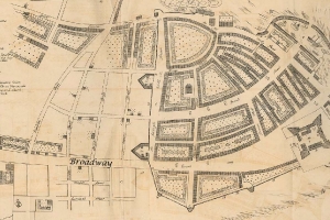
Evidenced by this map of what became the Financial District in 1695, Temple Street has been called thus for quite a long time. On the map, you can see it in the same space it occupied for the next three centuries, just below the large “Broadway” identifier I placed there. I had thought that “Temple” referred to Trinity Church, but the first Trinity was chartered in 1696 and the original building constructed in 1698. Note that Temple street runs for two blocks.
On the map, Fort Amsterdam can be seen in the lower right. The U.S. Customs House, now Museum of the American Indian (1900) now occupies this site. The fortifications on the north side of Wall Street also show up clearly. The full map can be seen here.
(Click on the above Gallery for a full-size version.)
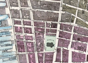
This is a portion of a Dripps atlas from 1867. Here we see Temple Street running for two blocks from Thames Street north to Liberty Street west of Broadway. Trinity Church and its cemetery are prominent. Also note that Church Street does not yet exist; it was created running north from Liberty Street and Trinity Place within the next two decades.
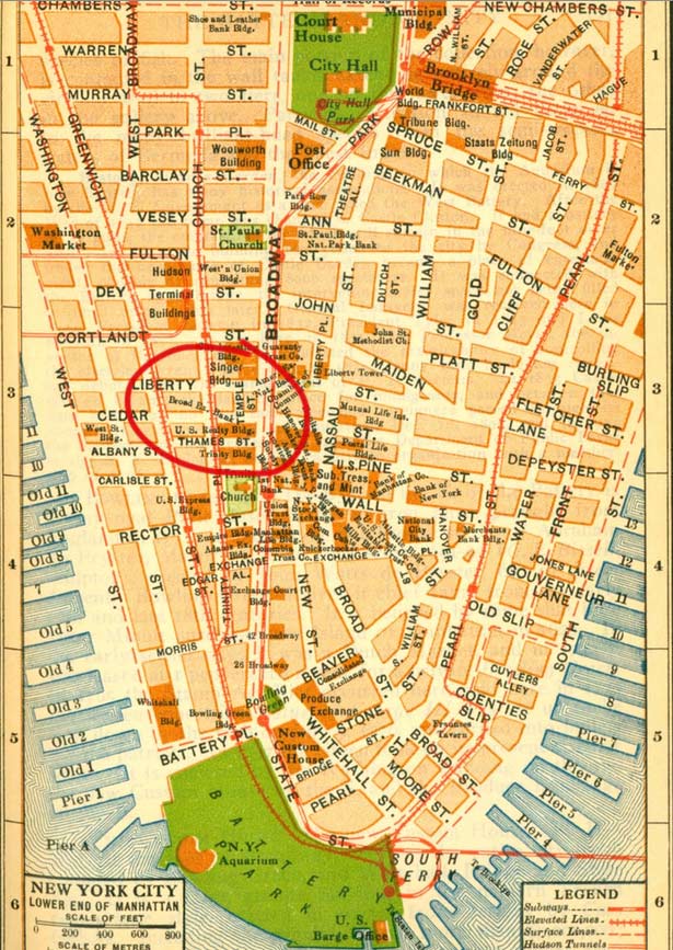
By 1916, Temple Street (circled in red) runs for just one block, from Cedar north to Liberty. It had been reduced to one block in 1907, when the Trinity and U.S. Realty Buildings, both tall Gothic towers built to complement Trinity Church, were constructed on both sides of Thames Street.
In 1967, it was decided that Ernest Flagg’s 1908 Beaux Arts skyscraper Singer Tower, one of the most identifiable buildings in the Manhattan skyline located on Liberty and Broadway, should come down. Singer, the sewing machine giant, had moved out in 1961 and U.S. Steel had purchased it in 1964. As big as the tower was, U.S. Steel found the offices and interior spaces too small and wanted a modern structure. This was before the Landmarks law had passed and pretty much anything was fair game (Pennsylvania Station was also a casualty in the same era); therefore the Singer same down…
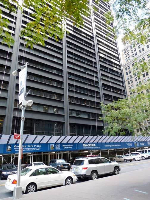
…and the forbidding U.S. Steel Building, later renamed One Liberty Plaza, was constructed in its place, opening in 1973. It presently hosts Goldman Sachs, Empire Blue Cross and Blue Shield, and many other Wall Street and insurance firms.
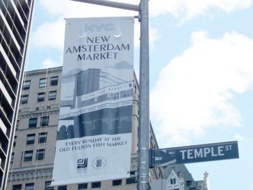
In 1968, when the Singer Tower came down, the small parcel across the street between Broadway, Trinity Place, Cedar Street and Liberty Street became Liberty Plaza Park, and the last piece of Temple Street was eliminated.
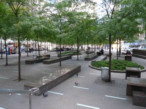
Liberty Plaza Park was affected greatly from the destruction of the World Trade Center a block away in 2001, and it was used for months thereafter as a staging area for emergency vehicles and equipment. Formerly a large, relatively shade-free concrete plaza, the park was given a rehabilitation in 2006-2007 when dozens of honey locust trees were planted and new fluorescent lighting was installed under the pavements, in an unusual arrangement.
For many years a highlight of the park was J. Seward Johnson Jr.’s “Double Check” sculpture showing a Wall Street businessman. After it was damaged on 9/11/01, it was later rehabbed and replaced in Zuccotti Park. Mark di Suvero’s “Joie De Vivre” tripod sculpture was installed on the southeast corner of the park in 2006.
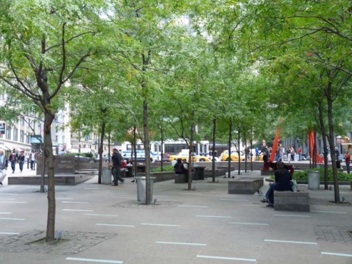
As part of the 2006 renovations the park was renamed for John Zuccotti (1937- ) NYC Deputy Mayor in 1975 under Abraham Beame, the chairman of the Real Estate Board of New York, and of Brookfield Properties, which owns the park.
In late 2011 and early 2012, of course, Zuccotti Park was the staging area for Occupy Wall Street‘s protest against economic inequality and it became known worldwide as hundreds, if not thousands, gathered in the park for several months.
Today, the sign is all that remains of Temple Street — which has an over 300-year legacy.
10/23/12


16 comments
Double Check still sits in Zuccotti Park
I did not see it, but I will amend the post.
It’s still Liberty Plaza Park as far as I’m concerned, just as it will always be the Brooklyn-Battery Tunnel, the Triboro Bridge, et al.
When I looked in on the OWS freakshow, “Double Check” had been reinstalled at Church and Liberty.
I’m with you Larry. The US Steel Bldg, now One Liberty Plaza, will always be the Merrill Lynch Building to me. That is what it was called, along with the moniker of ‘bbb=big black bldg’, when I worked in Manhattan 1974-1987.
As I see it,calling that park anything but “Liberty Plaza” removes any basis for calling the building at Broadway & Liberty Streets “One Liberty Plaza”.
I found this most interesting. My Mom is 78 and she remembers her Dad telling her that he had a brother born on Louis St, in Lower Manhattan, which her Dad told her no longer exists. My Mom would love some info on Louis Street if anybody knows anything. Thank you
There was never a Louis Street but there was, and still is, a Lewis Street.
Thank you
Kevin, Glenn’s post raises a question I think you might be able to help me answer.
The hospital I was born in (Hollis area in Queens) is long gone (late 50’s?)
You have any suggestions on resources to look for to get the hospital name?
Thanks,
It is listed on your original birth certificate.
I just found your website tonight when investigating an address my great uncle, Charles (Karl) Rothhaas lived at in 1915, according to a New York City Census. He and his wife lived at 41 Temple Street (a multi-family residence building), in Long Island City, Dist. 1, Queens, New York. He was a glass blower originally from New Jersey. I couldn’t find a Temple Street in current day Queens, and wonder if you might know what became of that street. I am trying to find the most likely place he was employed in glass blowing in that area. Thanks for any light you can shed on the 1915 Long Island City area of Queens and where 41 Temple Street might have been.
Temple is now 30th Road
http://stevemorse.org/census/changes/QueensChanges1_TtoZ.htm
I am researching Clara Foltz, the Lady Lawyer, who had an office on Temple Court in 1895. Are there any building of that era still standing? It was a very prestigious address at the time. I will be visiting NYC in mid September and would love to find her office.
The sign is there at my request. Neither Mr. Bloomberg nor Ms. Quinn cared enough to respond in any way whatsoever when I contacted them –many times — after the original sign was lost; they were not concerned with helping people find closure after 9/11.
Eventually, through other sources, I was able to get a commitment from the city to replace the sign.
The new sign was positioned on the lamppost closest to Broadway, a bit to the east of the center of the block, in January 2010, while the original sign was, appropriately, in the middle of the block.
Curiously, by early 2011, the new sign had been removed be persons unknown. Again I made inquiries and after more than a year of administrative red tape and delays relating to the Occupy Wall Street crowds, a second replacement sign was installed, perhaps in January of 2012, this time, a bit to the west of the middle of the block.
It is important to have the sign (a) to recognize the demographics that must have led to the original street name; New York was diverse, even in its earliest days, and it welcomed people of various religious persuasions; (b) to reflect the evolving geographic history of the area; (c) to acknowledge the people that once worked, lived, shopped, visited or worshipped there and those who passed by when the street was a vital place; and (d) to bring a smile of delight to people who see the sign today for the first time and think it is amusing to see a street sign when, clearly, there is no street there.
More simply, Temple Street is a part of our heritage. The fact that it existed and functioned for at least 265 years is reason enough to keep knowledge of its existence alive.
“[In the year 1903], if you turned into Thames Street, from busy Broadway, you came upon a mass of buildings in perpetual shade, and with a decidedly provincial air not at all in keeping with the up-to-date city. A walk of half a block brings you to Temple Street — a thoroughfare leading nowhere in particular, but which wise chroniclers have quarreled over, some urging that it came by its name because of being close by Trinity Church, which is a temple of worship, and others quite as vigorously contending that it took its name from Charlotte Temple, who lived near by. Here you find Reynold’s tavern.”
–Charles Hemstreet, Literary New York: The Knickerbocker Press, 1903, p. 118
Great info here, both in the original post and in the comments. Thank you for sharing your knowledge, people!