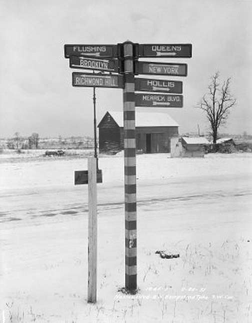
In the early 20th Century, Queens featured hundreds of striped poles featuring directional signs to different neighborhoods and even out-of-borough locations. This one, photographed in 1931, pointed to Flushing, Brooklyn, Richmond Hill, New York, Hollis, and Merrick Boulevard. Another sign points to “Queens,” but since we’re already in Queens, I’m unsure what was meant. Perhaps the civic center, then clustered near Newtown Creek.
[“Queens” probably referred to Queens Village; a LIRR tower near the Queens Village station is signed “Queens.” There was also a town in Staten Island (Richmond County) called “Richmond.”]
The sign was at North Hempstead Turnpike and Nassau Boulevard in what is now called Fresh Meadows; the roads are now called Booth Memorial Avenue and the Horace Harding Expressway, respectively.
12/6/12


9 comments
wow. no way i could have even guessed that!! an awful long way from merrick blvd.
Might mean today’s Queens Village, which in the old days was simply known as Queens, same as the county and borough.
Never knew these existed! Ya learn something new every day!
Queens most likely referred to what is now Queens Village.
Great photo, Kevin. I’m from this area. Appears to be facing in a northerly direction. I thnk the road in view must be Nassau Blvd. I’d love to see a higher res version of this photo if you have it. Feel free to send 🙂
Try this
http://nycma.lunaimaging.com/MediaManager/srvr?mediafile=/Size4/RECORDSPHOTOUNITARC-32-NA/1145/bpq_01065-o.jpg
After seeing this photo, I could never understand why they took down these signs either to never have any like these are again or replace them with a more homogeneous design, which is what is around today.
“The sign was at North Hempstead Turnpike and Nassau Boulevard in what is now called Fresh Meadows; the roads are now called Booth Memorial Avenue and the Horace Harding Expressway, respectively.”
Booth Memorial Avenue and the L.I.E. do not intersect; they run parallel to each other.
No, Booth Memorial Avenue meets the LIE at 186th Street.