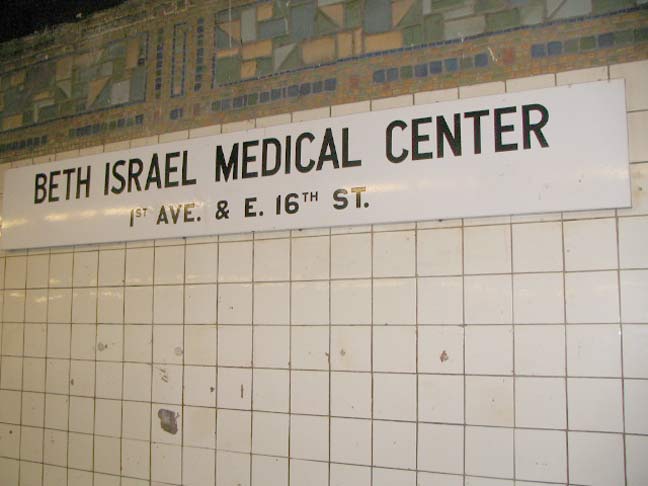
This black and white enamel sign in the 1st Avenue station of the Canarsie Line (L train) likely goes back to the early days of the line back to the 1960s on the line, which opened in 1928. If the MTA wishes to point out neighborhood highlights in subway signage today, it does so with gray and white signs using the Helvetica typefont. This sign is hand lettered.
This is the furthest east station on a Manhattan crosstown line — the #7 Flushing Line stops at Grand Central Terminal, while the IND line under 53rd Street and the BMT line under 59th stop at Lexington. Further uptown, Kips Bay, an inlet of the East River, makes Manhattan a bit narrower.
Beth Israel Hospital was founded in 1890 and opened its 13-story facility on 1st Avenue in 1929.
6/11/13


11 comments
I lived in stuy town when I was young. My dad owned the corner Blimpie for a while. I went to Stuy high school. My grandfather died in Beth Israel. I would see this sign on the way to my neighborhood bar, and when I went to visit my grandmother, and now when I see my brother.
I feel like I’ve been staring at this sign my entire life.
Where in Stuyvesant Town? I lived at 270 First Ave.
I would hazard a guess that it goes back to the late 1950’s to the early 1960’s, when Beth Israel built the corner tower on 16th St, and became a medical center and not just a hospital.
IIRC, the sign is from sometime around 1966-68, when the new building opened and replaced the one at Second Avenue and 17th Street.
I love how the sign painter rigidly kept to his lines for all the letters… except the A’s which poke impudently above the rest, and the V in “AVE” counterpointing the A.
Sign painters frequently do it like that. If they don’t the peaked letters will actually look shorter than the rest.
I agree with poster Jim90049. These signs are of 1950s vintage and were placed at stations where the TA wanted to point out a specific destination important to exiting riders. The same style sign was used at IRT, IND, and BMT stations, so the sign definitely dates from after 1953 when the NYCTA took over the subways from the old Board of Transportation.
I did not realize this 14th st station had exits up to 16th street.
The station does not have exits at 16th Street. The sign indicates only the location of this nearby hospital.
Know this station well…the stop for my high school. The entrances are on the east side of 1st Avenue, and they go down to the west end of the station, so the station is kind of faked-out, as far as being at 1st Avenue goes. It’s really between 1st Avenue and Avenue A.
It supported my school, Stuyvesant Village, and that whole chunk of the Lower East Side. For a good many years, the entrances had the original steel structures, which included the bases for the staircase entrances to the 14th Street station of the Second Avenue Elevated, which ran up 1st Avenue at that point. Those were replaced a good many years ago…they were rusting out.
Back then, it was still the “LL” train. It still goes to Canarsie.
I lived at 270 First Ave (Stuyvesant Town) on the third floor ( from 1956 – 1968) diagonally across from the Linsky Pavilion which was completed in 1966, a then-new component of Beth Israel. Any time my father and I went anywhere on the subway we started at the 1st Ave station of the Canarsie Line, and I remember this sign very well from back then.
An interesting story about the Linsky pavilion is that we used to be able to watch lightning strike the Empire State Building from our living room window, but when they built that tower it obscured our view.