I’m not ready to post regularly yet, till I get a machine of my own, and I may have to lean heavily on my archives for awhile.
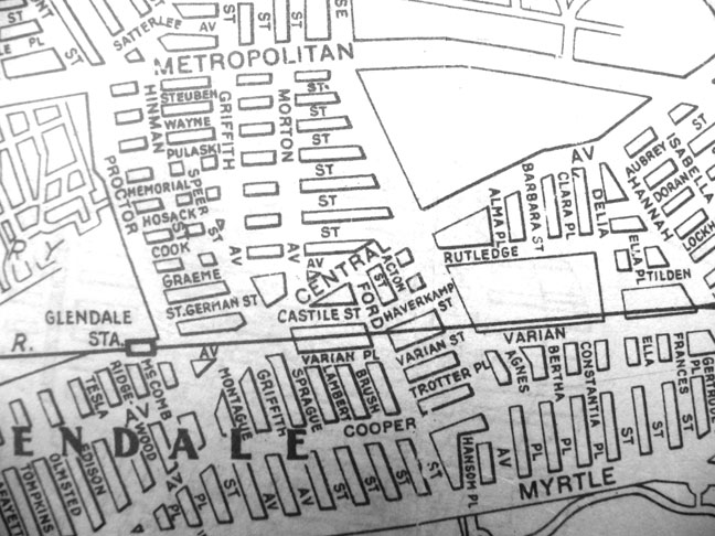
Here’s a piece of a 1922 Hagstrom map of Queens, showing Glendale. Though the numbering of Queens streets began in 1915, it happened neighborhood by neighborhood in a gradual process. It could be that Glendale was the last to make the switch.
How many of these streets have retained their old names and were not numbered?
12/4/13


18 comments
I grew up on Montague Ave.in the 50’s and 60’s and the principle mode of transportation was walking. I’d walk all over the place and soon discovered the topography which lead to learning the reason Glendale is between to “knolls”. Learned they were deposited during the ice age which lead to getting a degree in Earth Science. Say Kevin is ther any chance that you could publish the entire map of Glendale with the old street names? Thanks
Always wondered when and how they made the switch. (I’m in LIC / Hunters Point end). Did they just say ‘OK on May 1, 1917 your address changes.”?
Can you scan in the entire map, or make it available elsewhere? As to your question, on the map above, only Myrtle, Cooper, Central and Metropolitan Avenues are likely to have retained their names.
I can’t scan the entire map. This was done at NYPL a few years ago in their map room. They can’t scan the entire map on a drum scanner because of the ancient condition of the map, so I was left to aim my camera at selected pieces of it laid out on a table.
Do you have a photo with the right side of the map more centered? Hannah is my daughter’s name, she loves maps and we live in Glendale, so I’d love to make a print of that portion of the map for her.
The NYPL has this map, so they could dig it out for you, probably.
Actually, in comparing a current day Google map of Glendale, it appears very few streets retained their original non numbered names, and they all happen to be east to west (or conversely west to east) running Avenues. They are from north to south; Metropolitan Avenue (which is mostly in Middle Village today on the section of the 1922 Hagstrom map showing Glendale); Cooper Avenue which is the eastern extension of todays Central Avenue east of todays 73rd Place (formerly named Proctor Street in 1922); Central Avenue east to 73rd Place where it today transitions into Cooper Avenue; and lastly Myrtle Avenue whose name remains unchanged.
There’s also Cook, Doran, Rutledge
You got me. I missed those.
You can see the “I” for Indiana Avenue on the map between Ridgewood and McComb Places. Indiana never intersected Myrtle, although Hagstrom’s for many years showed it as such. Also Luther Rd, south of Cooper Ave between 69th Street and Place. I found Edsall Ave on a 1909 map, but not in its current spot, but rather 70th Avenue. Edsall is basically now the continuation of 70th Avenue that fronts the southern side of the LIRR Montauk branch. All these examples are also east-west streets.
On the right side of the map is Hannah and Isabella streets. Can anyone tell me what those streets are now? I thought Hannah might be 88th St, but I can’t get a good sense of bearings on the map.
Yes, Hannah is 88th, and although showing as going thru to Cooper Ave, Isabella is 89th St.
I grew up on another street that has retained its name…Margaret Place. It is only two streets long and is east of the intersection of Woodhaven Blvd and Union Tpke.
I am trying to locate a former storefront in Glendale. My great grandfather had a tailor shop, Pfundstein & Sons est 1896. The address I have is 1705 Myrtle Ave, they lived at 71-44 67th st Glendale and they were supposedly right behind the shop. Is anyone able to help me with the location? I am planning a visit soon and would really love to see it!
I also lived on 67th Street on the same block. The corner store on that side when I was growing up was a drug store (later some kind of food store), with a Chinese laundry next door and Rolle’s Shoes next to that (more or less). On the back side of the drug store was a small shop where shoe repair was done. 67th Street is excellent due to the different mix of architectural styles on it!
More-
From a 1929 map I found 1705 Myrtle Avenue, just east of Cypress Avenue in Ridgewood. Around 67th Street, the old numbers on Myrtle would be in the 2700 range.
A few more:
Southwest Glendale: Cypress Avenue, St. Felix Avenue, Clover Place, Cabot Road, Vermont Place.
Western Glendale: Cypress Hills Street
Northwest Glendale: Shaler Avenue and Catalpa Avenue.
(that little section east of Fresh Pond Road and south from the (M) train to Myrtle is Glendale).
Eastern Glendale: Trotting Course Lane (two sections) with an honorable mention – on some maps two addresses on Trotting Course Lane as listed as “Ruth Drive” and it appears that TCL took up a section of Ruth Place when Woodhaven Boulevard was completed.
I live in the section that is east of Fresh Pond Road, South of the M train, in between 68th Ave & Catalpa Ave.
I was told this area was Glendale.
However, it appears that in the future, it will become Ridgewood, especially if the new zip code comes through for Glendale.
My address is no longer listed in the boundaries of Glendale.
Confused.