
There are plenty of Dutch place names around town … Spuyten Duyvil, Knickerbocker, Onderdonk, and just about every name with a “Van” in front of it from Van Buren to Van Kleeck. There’s one name that was formerly found all over Brooklyn and Queens that has seemingly died out and left little trace: Kouwenhoven.
The progenitor of the family was the formidably named Wolphert Gerritsen van Couwenhoven, who immigrated to the “new world” in 1636, around a decade after the colony of New Netherland was founded at the tip of Manhattan. Van Couwenhoven purchased several acres from the local Native Americans in what is now East Flatbush and founded the settlement of New Amersfort (like New Utrecht, named or a city in Holland). The settlement was absorbed politically into the town of Flatbush. Today it’s remembered by Amersfort Place and Amersfort Park.
The Couwenhoven family spread out on western Long Island, into the rest of Kings and Queens Counties. Variant spellings of the family name such as Cowenhoven, Kouwenhoven and Kowenhoven appeared. In 1839, Cornelius Bergen Kouwenhoven built a grand mansion in East Flatbush at what became Kings Highway at Avenue D in what is now a mixed residential and industrial era. The mansion disappeared in the mid-20th Century.
However several Kouwenhovens left place names behind, which have all disappeared but not without leaving some traces behind. Today I’ll talk about some of these.
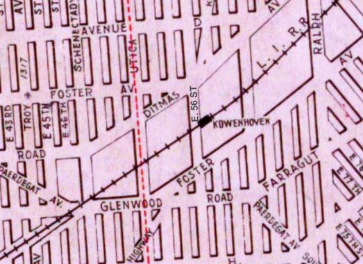
The Bay Ridge Branch of the Long Island Rail Road still runs from Fresh Pond Yards to the Brooklyn waterfront at the Brooklyn Army Terminal. Though passenger service ended in 1924, it was used to transport draftees to the Terminal where they would board ships to whatever destination they were assigned; in 1958, Elvis Presley rode one of those trains en route to the boat that would bring him to Germany.
The Kouwenhoven station on the Bay Ridge Branch, at East 56th Street near Ditmas Avenue in East Flatbush, has been long eliminated and today, a much widened version of Kings Highway crosses where it had been. The station no doubt was named for the Kouwenhoven mansion that stood nearby.
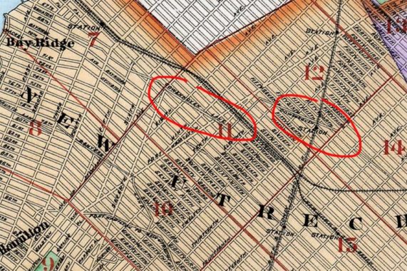
Until the 1920s when the prevailing grid of Bay Ridge and Borough Park was built out in what was the Town of New Utrecht, a country road called Kouwenhoven Lane zigged and zagged across the fields. It became disused and later houses were constructed on its old route. Most maps spell this lane “Cowenhoven.”
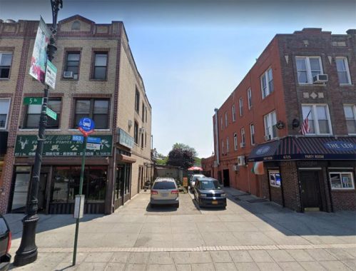
The only trace of that Kouwenhoven Lane is an especially wide driveway at 5th Avenue and Senator Street near Lief Ericson Park.
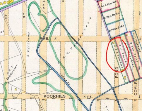
The trickiest Kouwenhoven Lane to locate is way out in eastern Sheepshead Bay near what is now one of the smelliest sewage treatment plants in the city (and in a residential area to boot) at Avenue Y and Knapp Street. If you follow Avenue Z east and turn right on Ford, you will find a short lane angling off to the southeast. This 1890 map shows it as one of three such lanes that existed before the present streets, shown in a buff color, were built.
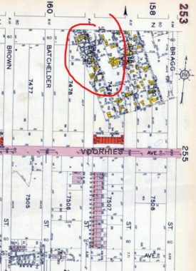
Moving forward to 1929, we see that the street grid was still not yet built out for the most part; the red, purple and yellow squares are houses. At Avenue Z at Ford and Coyle Streets, you still see the three angled lanes, with dwellings lining them.
In the postwar years, these streets were fully built out, and the properties in mapped roadbeds were purchased and condemned by the city. However, one of these former lanes, that I understand was called Kouwenhoven Lane, is still there…
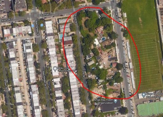
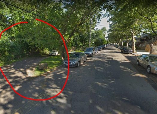
… as this aerial view from Google indicates. You can see that the buildings angle to match the route of the older road. I am unsure whether these buildings now have a Ford Street or Kouwenhoven Lane address, so if anyone knows, the floor is yours in Comments.
As an aside, I took my road test around here in early 1976. It was the day after a substantial snowfall and I got the car stuck in a snowdrift. I haven’t taken another road test since.
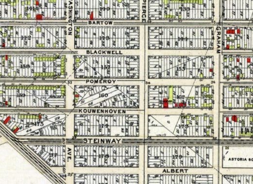
Before streets in Astoria, Queens, were numbered in the 1920s and 1930s, 38th Street, a block west of Steinway Street, was called Kouwenhoven Street as this 1909 map indicates. There had been another Kouwenhoven mansion at 38th Street and 20th Road, now the site of a public school.
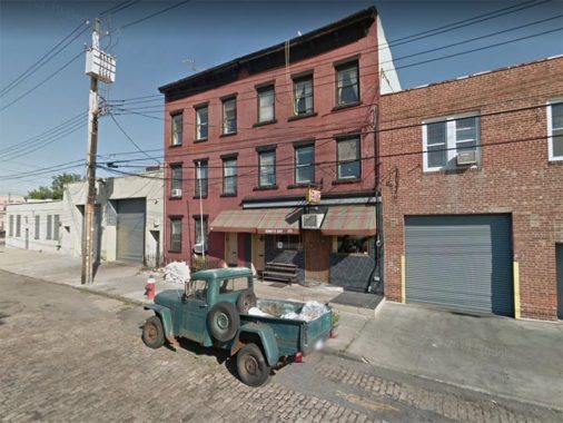
Are there any traces of the Kouwenhovens remaining? As the centuries passed the name continued to be altered, and evolved into Conover, a name more pronounceable by English speakers. Here is Conover Street at Sunny’s Bar between Reed and Beard Streets, named for early 1800s landowner John Conover.
Check out the ForgottenBook, take a look at the gift shop, and as always, “comment…as you see fit.”
10/13/20

18 comments
Another existing remnant is a jogged 54 th street in BoroPark between 15 and 16 aves. I have traced the path of the lane in the area and have found other evidences of its former route. It was demaped about 1909 or 1910. It’s footprint where it once crossed New Utrecht Ave before the trains were elevated is now occupied by a CitiBank building which was Originally built as a post office edifice In 1910. I
Gertrude Ryder Bennett (of the Wyckoff-Bennett Homestead) had an aunt who married a Kouwenhoven. They lived along the stretch of Kings Highway near the L.I.R.R. station, and actually referred to it as “Kouwenhoven Place.”
I’m a direct descendant of the Kouwenhoven family. My mother was Phyllis Kouwenhoven. Daughter of Frank W. Kouwenhoven. He was the son of Teunis Garret Bergen Kouwenhoven. Mom fondly remembers visiting the Wyckoff-Bennett Homestead as a girl. I went and found it in December of 2018 as I had never seen it in person. Mom told me that Hessian soldiers had been quartered there during the Revolution and had carved their names in a windowsill.
NOt exactly a remnant but a remembrance of the name is a beer bar in Crown Heights a short walk from the Franklin Shuttle is Covenhaven a beer bar / food court. I am guessing hte name is smehow derived from the subject of this blog.
Do you know of a comprehensive resource (book?) that examines the history of Queens street names prior to numbering? I was hoping for a
borough equivalent of John McNamara’s History in Asphalt.
google “steve morse” and queens
The photo that you used at the beginning & the end of the history lesson contains another piece of history: a Willys Jeep pick-up truck. It appears to be someone’s daily driver. Note to the owner: there are probably many Jeep cult followers who would make you generous offers for it.
Great article as always, learning the history of ancient streets. I used to live in East Flatbush and I called the Bay Ridge Branch simply the “Freight railroad” – I did not know its official name until many years later, nor that it used to have passenger trains. The Kouwenhoven station on the Bay Ridge branch was at E. 53 St, not E. 56.
I suspect that Gerritsen Ave in the same area of Brooklyn shown on your maps is named after the same Dutchman
Not trying to be annoying, but wouldn’t Kouwenhoven street in Astoria really be west of Steinway?
All right, all right.
Would the little lane in the middle of East 28 Street between Ave. Y & Z that used to be called Voorhies Avenue (and rumored to be the site of the Sheepshead Bay Race Track) a Kouwenhoven trail? As kids, we used to call it “down the lot.”
That’s a remnant of Jerome Avenue.
The NYCityMap also shows that stub as Jerome Avenue. BONUS! On Google Street View, I found 2811 Jerome Avenue.
Here is a Trulia ad for a house on Kouwenhoven Lane:
https://www.trulia.com/p/ny/brooklyn/2648-kouwenhoven-ln-brooklyn-ny-11235–2009868111#lil-mapViewTab
It looks like the street coming in from Coyle St. Google Maps also calls the lane coming in from Ford St. Kouwenhoven Lane.
The NYCityMap dutifully has Kouwenhoven Lane marked.
http://maps.nyc.gov/doitt/nycitymap/
Does anyone know the Company that purchased the KOUWENHAVEN Manchion on avenue D and Kings Highway in Brooklyn they purchase it knocked it down and build an apartment complex what was the name of that outfit
We just went to Greenwood cemetery and found a bunch of graves with the name Kouwenhaven next to the Bergen family. We enjoyed learning more about their connections to Brooklyn and Queens, especially New Amersfort and Amersfort park because we live right near there!