The railroad tracks running along Manhattan and the Bronx’s Hudson River frontage are on what is among the oldest railroad right-of-way in the country. The New York and Hudson River Railroad was incorporated in 1847 and laid tracks along the river to connect mid-Manhattan with upstate locations; by 1849 the railroad had reached Peekskill. A wood trestle was built across Spuyten Duyvil Creek. At the creek, the division between Manhattan and the Bronx is quite clear. East of there, though, things get complicated.
In a little-known quirk of geography, a small piece of the borough of Manhattan, known as Marble Hill, is on the mainland. It is surrounded on three sides by the Bronx and on the south by the Harlem River. It shares its character with the neighborhoods of Kingsbridge and Kingsbridge Heights on its north and east. It is protected from Spuyten Duyvil, on the west, by a steep hill.
In 1895 it was separated from the island by the newly straightened, dredged and deepened Harlem River Ship Canal, leaving Marble Hill as an island itself. When, in about 1917, the creek was filled, Marble Hill became a part of the mainland!
No one cared much until the el was built through Marble Hill and apartment buildings were constructed in the 1920s, joining the few frame houses that were already there. Marble Hill never changed its designation as part of Manhattan, and so a part of Manhattan it stays, separated from the rest of the borough by the Harlem River.

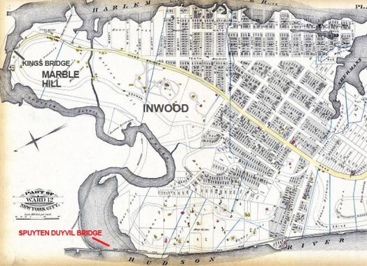
Here’s an 1885 map showing Manhattan, Bronx, and Spuyten Duyvil Creek. At this point, Marble Hill was an island separated from Manhattan Island by a narrow channel which would be expanded into a canal. later, of course, the Harlem River was redirected west to join the Hudson River. However the western end of Spuyten Duyvil Creek is unchanged in width from 1885, and is still spanned by a bridge of about the same length.
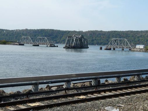
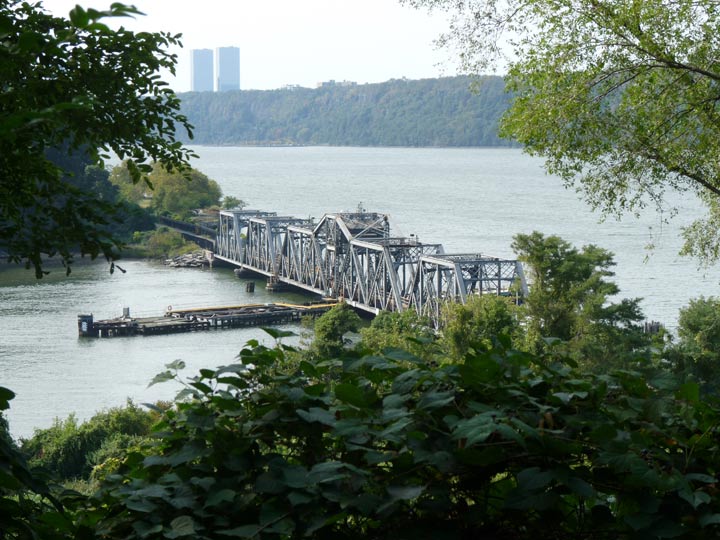
The swing bridge we see today was built in 1899 by engineer Robert Giles and is about 600 feet in length. The central section is 290 feet across and can be swung round to allow shipping to pass with the aid of an electrical engine. In 1983 a Circle Line boat struck the bridge and necessitated an overhaul. The boats that use the Harlem River at this point for the most part are Circle Line boats. The captain places a call to the bridge operator to swing the bridge open to allow passage.
New York Central/Conrail used the tracks exclusively until 1991 when Amtrak switched its terminal from Grand Central to Penn Station, necessitating running some routes along the tracks.

On October 10, 2020 I was lucky enough to see the swing bridge in both closed and open positions from the Spuyten Duyvil Metro North station, though I did not see it actually turning, nor did I see what boat required passage to the Hudson River.
Check out the ForgottenBook, take a look at the gift shop, and as always, “comment…as you see fit.”
10/12/20


19 comments
Very recently they demolished a small 2-story railroad building at the north end of the Spuyten Duyvil railroad bridge where Amtrak joins Metro North. Judging by old photos, that building was a switch tower that controlled things like trains going west and then south across the Harlem River. Or trains heading north from Manhattan and then immediately turning east once they crossed the Harlem. It was a good-looking building for what it was and it’s a shame it’s gone.
Demolished building was former New York Central Railroad “DV Tower”. I hung out there a lot when I lived nearby, between
1948 and 1955.
I lived in Marble Hill recently. All services and schools are the Bronx and it pretty much looks like the Bronx. But jury duty and voting are New York County. They tell a story at jury duty from when the system was still manual where a Marble Hill woman was called to Bronx criminal and helped render a verdict. Judge had to declare a mistrial.
Excellent posting. The north end of the Harlem River hosts three notable bridges – the Broadway, Henry Hudson, and Amtrak Spuyten Duyvil. The last one gets the least amount of notoriety of the three, so it’s good that its own interesting history is highlighted.
However, one correction is needed. Metro-North has never used the tracks on the Spuyten Duyvil Bridge or in Manhattan to the south. Those tracks were originally the New York Central RR until 1968, then were Penn Central (1968-76) and Conrail (1976-83). Passenger trains on the route south of Spuyten Duyvil disappeared by the early twentieth century, but freight service lasted until about 1980. In May 1967, during the last full year of the NY Central RR, two freight trains collided head-on on this line at 147th Street, resulting in the deaths of six railroad workers – the engineer, brakeman, and fireman on each train.
In 1983 Metro-North succeeded Conrail as the operator of the commuter services to and from Grand Central. Amtrak’s long distance trains between NYC and upstate NY and Canada, known as the Empire Service, used the Grand Central route as well, and shared trackage with Metro-North south of Poughkeepsie. Both services were originally the New York Central RR. In 1991 Amtrak consolidated its entire NYC train service at Penn Station, which allowed it to close crew and commissary facilities at Grand Central and allow passengers easy transfer between Northeast Corridor and Empire Service trains. Thus a person travelling between Baltimore and Albany on Amtrak only had to change trains at Penn Station, instead of trekking between Penn and Grand Central. The missing link was a short tunnel connecting the west end of Penn Station with the old NY Central RR West Side Line, known as the Empire Connection.
I’m confused. How would this sentence be rewritten?
New York Central/Conrail/used the tracks exclusively until 1991 when Amtrak switched its terminal from Grand Central to Penn Station, necessitating running some routes along the tracks.
OK looks good. Key point is that Metro North never used the tracks in Manhattan south of the Spuyten Duyvil drawbridge. Those tracks were essentially dormant from 1980, when the last freight train ran, until 1991, when Amtrak began sending Empire trains to Penn Station. The idea was nothing new, as the NY Central and Pennsylvania Railroads announced in the mid-1960s that if and when they merged (occurred in 1968), all New York City long distance trains would use Penn Station and Grand Central would be for commuter trains only. The missing link was the short tunnel connecting Penn Station to the NY Central West Side line, which goes beneath the LIRR West Side Yard (itself on the site of an old NY Central freight yard that was fed by the West Side line).
What exactly lead to having what’s now the Hudson Line of Metro North RR to being rerouted to its current route hence longer using this bridge?
In 1871 the New York Central RR opened its new Grand Central depot at 42nd St., consolidating passenger operations on what are now today’s Hudson, Harlem, and New Haven Lines of Metro North. Those lines were separate railroads 150 years ago. As a result, most NY Central passenger trains that had used the route along Manhattan’s West Side (today’s Amtrak route south of Spuyten Duyvil) shifted to Grand Central. The West Side route remained as an important freight line until the 1970s, but most passenger service on it had ceased by the early 20th century.
It’s a very long story if you like details, but that’s it in a nutshell.
I heard this as a kid from a book on New York folklore-A Dutchman wanted to cross the river there.The Devil wouldnt let him and so the Dutchy tricked him somehow and so he crossed the river in Spuyten Duyvil(In Spite of the Devil)
There are a few swing spans remaining in South Carolina, including the Ben Sawyer bridge connecting Sullivans Island and Mt Pleasant in Charleston County, which fairly-famously was blown off of its mountings by Hurricane Hugo in 1989, stranding island residents who had chosen to ride out the storm (a bad decision for many reasons).
https://youtu.be/pMPqu0_wkM4
Sadly, a quaint swing bridge that I traversed regularly was deemed “structurally deficient” (i.e., it was throttling car and boat traffic to areas that developers want to exploit) and was replaced by a soaring four-lane monstrosity.
https://www.scpictureproject.org/charleston-county/wando-river-swing-bridge.html
What a crime to have demolished the switch tower building!
Does anyone know of an historic house in Spuyten Duyvil once owned by Dr. Junius and Mrs. Peggy Bird? It had a champion tulip tree in their yard and each year they invited staff from the American Museum of Natural History where he worked in the Anthropology Department to their home. Magnificent tree and house. He was an expert in South American textiles and quite a character at AMNH in Manhattan.
I note that the part of the mainland now attached to the island is, however, now part of Manhattan. (I think it’s the Columbia sports complex.)
No, my mistake: It’s part of the park, if it still exists at all.
“”On October 10, 2020 I was lucky enough to see the swing bridge in both closed and open positions from the Spuyten Duyvil Metro North station, though I did not see it actually turning, nor did I see what boat required passage to the Hudson River.”
Kevin, The bridge stays open all the time for maritime traffic until an approaching train train necessitates the closing of the span
We used to swim in the river and jump off the “big C” across from the Columbia field. It was especially good when the Circle lines sailed by and the captain would tell the passengers to clap for us.
Best map I have found today of the King’s Bridge location across” Spuyten Duyvil Creek, which is where Gen. George Washington led the Continental Army” en route to Manhattan from their success routing the British from Boston in 1715. I was reading The Firt Conspiracy by Brad Melzer and Josh Mensch this morning and wanted to actually identify the location of the King’s Bridge to orient myself geographically before continuing my read. This was by far the best map depiction and written description I found available online for my impulsive historic detail search. Thank you.
The year was 1775 – I hate typos. sorry about that.