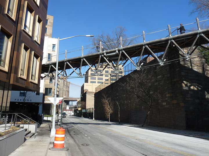
FROM the Forgotten New York archives of January 2018 comes this look at the first Squibb Bridge spanning Furman Street, from Squibb Park at Columbia Heights north of Cranberry Street crossing Furman Street to Brooklyn Bridge Park. Most people familiar with this area today may think that the BQE, which was bruited through in the 1950s, cut the Brooklyn waterfront off from the streets of Brooklyn Heights. Not true. Here, the topography is harsh and Brooklyn Heights is set on a high scarp overlooking the water, which is way below. Furman Street was laid out along the waterside in the 1800s and subsequently, warehouses and shipping establishments sprang up along its length, and a short railroad was constructed to get goods between these buildings and onto ships docking there.
After the Age of Container Vessels began in the 1960s, shipping eventually moved to New Jersey and away from Brooklyn, and the docksides were nearly completely empty by 1990, with the Furman Street area orphaned. The Department of Parks stepped in and constructed Brooklyn Bridge Park, which, in several sections, now stretches from Atlantic Avenue north and east all the way to John Street in DUMBO.
Thus, there were never many ways to get from Brooklyn Heights to the waterfront; trucks used Atlantic Avenue on the south and Fulton Street on the north to get there. Montague Street had a pedestrian ramp and an iron bridge, Penny Bridge, to reach Furman (the BQE obliterated that) , and Joralemon Street for local traffic, but that was it. Furman Street was further cut off by the double-decked BQE, which is now falling apart after nearly 70 years, with the local politicians disagreeing how to fix it and where to reroute the traffic, or tear it down entirely. Atop it sits the Esplanade, or Promenade as Brooklynites call it, a true marvel offering Manhattan views.
The Squibb
With the new Brooklyn Bridge Park under piecemeal construction, engineers were faced with a challenge: how to get foot traffic from Columbia Heights across the Furman Street gulch to the new park. Thus the first Squibb Park Bridge was conceived and completed in late 2012.
The bridge was constructed of Black Locust timber with bronze and galvanized steel connections that echo the material palette of the park. Black Locust timber is naturally rot resistant and an unusually strong, durable, and sustainable resource. The bridge consisted of two under-slung suspension spans that open up views in all directions when crossing Furman Street. The bridge had 42-inch-high lighted railings that are consistent with railings for the adjacent Brooklyn Heights Promenade and on the Brooklyn Bridge. The bridge was also ADA accessible.
The first Squibb Bridge produced little bounce in your step. The bridge was designed with trail bridge technology and was meant to be lightweight and flexible like the trail bridges in our state and national parks.
The Squibb Park Bridge did indeed have a little give, and swayed just a little as you crossed it, though certainly not enough to trigger a seasick reaction. The experience reminded me a little of the Capilano Suspension Bridge (constructed in 1889 and renovated in 1956) over the same-named river north of Vancouver, BC.
After a few years, enough people complained about the swing and sway without Sammy Kaye, and flaws were discovered in the construction that were enough to close the bridge completely. Using the stanchions supporting the first bridge, a second Squibb Bridge, much more rigid with no swaying or give, opened to the public in 2020.
As always, “comment…as you see fit.” I earn a small payment when you click on any ad on the site.
11/18/21


2 comments
I found when walking over the first bridge that you could move left to right and soon induce a swaying motion which, if you persisted, caused the bridge to sway a foot or more. Apparently a lot of people found this unnerving. It also put stress on the timbers and supports, and after spending millions on the bridge, it was closed and replaced by the curent structure. Ironically, I never go to the Brooklyn Bridge Park now because, especially in the summer, it’s too crowded.
The waterfront was never that isolated. It takes five minutes from where I live in the north Heights to walk down Columbia Heights to Old Fulton Street, or I can walk about 8 minutes south to Joralemon, which goes all the way down to Furman Street.
The freight railway along the waterfront originally ran from Red Hook to DUMBO on the north, with a terminal just below the Promenade where the stub of Montague Street is. Although the stub is still streetsigned as Montague at water level, it’s unconnected to the one above. As you wrote, the incline which took streetcars running along Montague Street down to the docks and the Penny Bridge, which arched oveer the Montague Street cut wwre both eliminated when the BQE was rammed through. That obliterated all the stores and offices along Furman Street, as well as the gardens that backed the houses along Columbia Heights.
[Ironically, I never go to the Brooklyn Bridge Park now because, especially in the summer, it’s too crowded.]
“Nobody goes there anymore, it’s too crowded.”
– Y. Berra