I was thinking of West Maspeth, a part of town few but its inhabitants give a second thought, specifically the region just east of the Long Island Rail Road Montauk Branch tracks between Maspeth and Grand Avenues. Until fairly recently, I could have lunch at a diner whose history went back to the 1930s, visited a church constructed in 1847, and rode a railroad train that stopped nearby; currently, all three are now impossible.
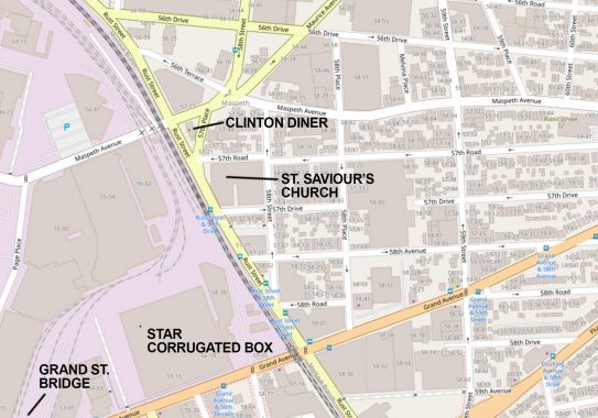
On this page I’ll discuss the highlights pointed out on this map excerpt. This is an area of light industry, especially in the westernmost area, and middle-class housing. Grand Avenue is the main commercial strip, but doesn’t attain that status until one proceeds east to 61st Street, just off the map on the right.

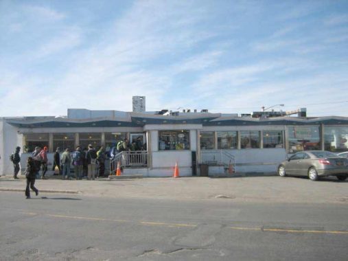
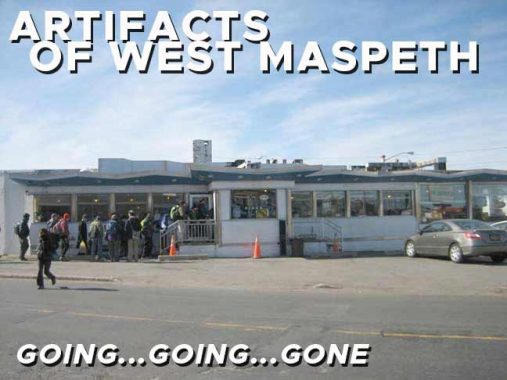
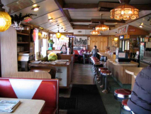
The Clinton Diner, at 58th Street and Maspeth Avenue, was one of a vanishing breed of roadside diners, catering to workers in an industrial area and motorists who are passing through. It stands next to freight tracks of the Long Island Rail Road. DeWitt Clinton’s mansion, for which the diner had been named, stood nearby until 1933. A house belonging to family members of mid-19th Century Maspeth mover and shaker James Maurice is across the street. Community meetings took place here, and it had been used on numerous occasions for movie and TV shoots when a scene needs authenticity. One of those was the film Goodfellas where a scene with Robert DeNiro and the late Ray Liotta was filmed; diner owners the Diamantis family renamed the Clinton Diner Goodfellas Diner in its honor. Other TV shows such as the Good Wife, Six Ways to Sunday, the Americans, and Elementary also filmed scenes there. The diner’s location on a main truck route, its isolation, and its 1960s decor make it irresistible to directors searching for period atmosphere.
The Clinton Diner originally opened in 1935, when memories of the DeWitt Clinton Mansion were still fresh. The mansion, in a precursor of the diner’s fate, had burned down two years earlier in 1933. In 1964, the diner assumed its present appearance when it was remodeled to its latest appearance. The De Raffele structure resembled the Market Diner at 11th Avenue and West 43rd Street, built about the same time, and closed in 2015.
Additionally, it’s not every day you walk into a diner and find your website on the menu, but that’s what happened to me in 2011 when I found Forgotten NY there (see above gallery).
The fun ended in June 2018 when a devastating fire gutted the diner’s interior. The diner still stands, with plywood instead of windows. After initial indications from the Diamantis family that the diner would reopen, it hasn’t happened. Google Street View shows a blur in its place.
St. Savior’s Church (Episcopalian) on Rust Street and 57th Drive had been there since 1847, designed by Richard Upjohn in what had been open country in that era on land donated by James Maurice, a prominent lawyer, politician, and landowner. It was torched by vandals in 1970, and was considerably altered after that and was later renamed and occupied by a Korean congregation. Maurice’s name was affixed to a major Queens thoroughfare running along Mount Zion Cemetery from Maspeth to Woodside, and one of his family homes still stands on Rust Street and 57th Avenue.
When the Korean church moved out in 2006, Maspeth Development LLC took ownership and announced plans to raze the church. Civic groups such as the Juniper Park Civic Association, then led by current Councilman Robert Holden, and other preservationists expressed interest in saving the church, but pleas were met with stonewalling from other politicians as well as the Landmarks Preservation Commission, which held that the church was too greatly altered from its original appearance to save. In 2008, the church was disassembled, its pieces labeled and placed into storage; it awaits reassembly…somewhere…today. Warehouses occupy the church’s footprint today.
Built in 1925 (as indicated by a terra cotta sign at its roofline) at 55-15 Grand Avenue just west of the railroad, the handsome brick Star Corrugated Box epitomized western industrial Maspeth. In its later years it served as a truck depot. After local politicians thwarted Amazon’s plan to build office space in Hunters Point in 2019, Amazon purchased the property the following year and quickly razed the box factory and built a 1 million-square-foot delivery station, the bulk of which is dedicated to van storage; you have no doubt seen Amazon’s dark blue vans on NYC streets delivering packages.
Just east is 57th Street, which dead ends at the railroad cut. This street actually used to be called Flushing Avenue…though it was not part of today’s Flushing Avenue. FNY explains here.
Hanging on for dear life, though not, it appears, for too much longer, is the venerable Grand Street Bridge, the oldest of the many bridges spanning the noxious and noisome Newtown Creek and its tributaries. I should do a survey of the Creek bridges while it’s still there.
The bridge passed its centennial with little fanfare in 2002 (it was opened in December 1902 or February 1903, depending on what source you use) and as old as it is, two previous bridges bridged the Newtown before it. The first, constructed in 1875, became dilapidated and un-maintenanced (in a typical NYC and Brooklyn story) and was replaced in 1890, but was declared by the US War Department (now the Department of Defense) as a threat to navigation. Plans for a new bridge, the present one, were drawn up in 1898.
Grand Street and Grand Avenue, as the road is known in Queens, together are about 120 years old. Grand Avenue was engineered in the late 19th Century as an eastern extension of Williamsburg’s Grand Street, and was known as a Street in the early years of its existence before the Queens section became an Avenue, likely to differentiate it from Brooklyn. In Queens, the road’s eastern course overlapped the course of the Newtown Plank Road, which is today’s Maspeth Avenue as far as its eastern junction with Grand and Flushing Avenues. (Flushing Avenue itself is a straightened version of a colonial-era route called the Brooklyn and Newtown Turnpike.)
Plans call for it to be replaced with a modern span, which will no doubt be functional and boring, within a few years. More photos on this FNY page.
As always, “comment…as you see fit.” I earn a small payment when you click on any ad on the site.
2/11/23
