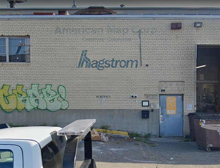
WEST Maspeth, also known as Laurel Hill, was world headquarters of Hagstrom Maps, whose plant is shown here on 46-35 54th Road near 48th Street. Though the company moved out long ago, its old painted sign was covered for awhile but is now visible again.
My former webhost Paul Matus was employed at the company in 1967 and remembers:
“Every now and then, when [founder Andrew Hagstrom, still there after 50 years] encountered me in one of the hallways of the building, he would talk me and he loved to take me over to one of the documents on the wall which featured the Hagstrom logo, a Viking ship on the high seas. He told me that the ship represented him, who came to the U.S. without two Kronas to rub together, and through hard work built up this great business. But his special satisfaction was in telling me that he didn’t have a college degree and didn’t much care for people who did. ‘I never went to college but now I hire and fire college graduates everyday,’ he said with great satisfaction. He must have told me the story a half-a-dozen times, as though he had never told it to me before.

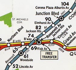
“Of all his maps, his New York City subway map appeared to be his pride and joy. It was the official map during the 40s and 50s and was in the New York Telephone yellow pages until the TA hired someone else to produce its more diagrammatric London Transport-style map about 1958 which the old mapmaker disliked. He thought maps should be graceful looking and reasonably geographically correct. Even after the TA abandoned the traditional BMT, IRT and IND divisions on its map, Hagstrom retained them and their traditional map colors: BMT yellow or green, the IRT blue, the IND red, and elevated lines as thin black lines.”
All these years later, that original Hagstrom subway map remains the gold standard, in my opinion.
Here, map historian Peter Lloyd discusses the great Hagstrom subway map in a NY Transit Museum chat.
|
|
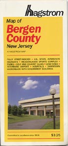
I am a near obsessive NYC street map collector and I own close to five hundred street maps from around the country, not just NYC. I got hooked by Hagstrom in the early 1970s when I made most of my early purchases with allowance money. I’ve followed Hagstrom’s distinctive cover designs for decades the way record aficionados follow 45 RPM sleeves and labels. (Click on each image for a complete view.)
When I was beginning to collect Hagstrom in the early 1970s they were beginning to modernize their cover design with Helvetica type and streamlined art. New York map covers in the 70s were black with red trim, while New Jersey maps were blue. Occasionally though, Hagstrom would toss in a wild card, like their 1971 Queens edition with a green duotone of LaGuardia Airport on the cover. Their Philadelphia edition was blue, but with Optima type. The back covers of most of these maps were bright red with black type. Atlases usually followed suit with similar color and designs. As you can see, I added the date of purchase with Dymo labeling tape.

Throughout the 1980s and 1990s Hagstrom used a distinctive yellow color scheme with either red or green type and a new logo. The tyepefont was a variant of Franklin Gothic with a modified x-height. By the early 2000s, as digitally drawn maps began to make a move, the typefont was changed.
Hagstrom had always published specialty maps in addition to street maps, including subway and bus maps. This one from about 1960 (if you go by the GM ‘fishbowl’ bus drawing on the cover) features the Viking ship logo, which was getting rare by that time.
After becoming part of the Langenscheidt Publishing Group, Hagstrom found itself part of a stable of companies producing 4000 US and international street maps. The company left West Maspeth in 2005.
My history with Hagstrom runs thusly: My mom brought me to Hagstrom HQ on 33rd St in September 1971. I was looking for their Philly edition, which of course was unavailable for the most part in NYC (in those days, out of town maps were available only in dedicated map stores). The receptionist was friendly and helpful. Their Philly map is the best of that town I have ever seen; it was discontinued in the early 90s.
After I sent in several corrections in 1981, Greg Christiano of Hagstrom asked me in to interview for map researcher. I was not chosen (the job required a car to get around) but I enjoyed the tour around the plant in the days before computers and CAD.
I was between jobs again in ’92 and for the heck of it, interviewed again at their Laurel Hill plant. Each time, the pay stated was lower than I would have liked to make, but still, I would have enjoyed working for them part time at least.
Here we are over 50 years after I got my first Hagstrom. Former employee Paul Matus was my webhost for several years, and his friend Greg Christiano, who interviewed me in ’81, has posted his own Hagstrom recollections.
As always, “comment…as you see fit.” I earn a small payment when you click on any ad on the site.
6/27/23


27 comments
I recall purchasing maps at one of their retail stores in Manhattan. The website links on this page has a lot of great reading material.
I visited the Hagstrom store on 43rd and 6th regularly. I also patronized the Rand McNally store on 53rd Street. Though by then the store had closed, it was in the same building as the publisher of Forgotten New York The Book, Harper Collins.
I to am a map aficionado..
Where cam you purchase old Hagstrom maps ?
Ui have a few of NYC and Long Island that are dated now..
Did they use Hagstrom maps to lay out the grid for the 64
Worlds Fair exhibit at NYC pavilion?
Try EBay, they have a selection.
We have a 4’x5′ framed 1982 Hagstrom map of the five boroughs on the lobby wall of our office in Long Island City. Regularly, young customers and drivers stop and examine it for a few minutes with a curiosity and interest as if it was the Rosetta Stone.
If satellite-assisted mapping systems, like Waze, etc., failed for even a few days, those of us over fifty years of age will be the only people capable of navigation. We will pull out our ancient Hagstrom or AAA maps and blithely go on with life as though nothing had happened. The roads would be empty because the younger folks would all stay home.
Kevin, Thanks so much for posting the Hagstrom info, I am especially impressed by the link to Peter Lloyd’s presentation for the Transit Museum. A great resource! I have been a big fan (really a fanatic) of City maps since my grammar school days in the early 50s in Elizabeth NJ when a classmate told me a local [Hagstrom] map showed our little enighborhood park, AND even the pedestrian lanes within the park. My next stop was the neighborhood stationery store to buy my first map. -Al Trojanowicz, Middle Village, NY
Had a job that required driving around the City and always used Hagstrom Maps, GPS of the day.
Always good to read your Hagstrom posts Kevin.
An unusual judgment by Hagstrom happened after the Langenscheidt takeover: a design-centric edition of the 5 Boro from 2001. It’s all about the glitz layout and imagery. Can’t post here, understandably, but this strange edition is findable on ebay.
One of the fun things about map-making is the intentional errors that exist on maps. They could be a small street that doesn’t really exist, or a slightly incorrect spelling of a name. They were the “easter eggs” that map-makers hid on their maps which, if found on a competitors map, allowed them to identify copyright infringement. For map geeks (whoops, I mean aficionados), like me, it was always a thrill to find one.
I still have all my Hagstrom maps from the 1960s, including fold-out maps of the boroughs as well as Nassau and Suffolk County atlases.
When service stations* no longer offered road maps, Hagstrom books became a necessary convenience for me until Windows featured Bing Maps & Driving Directions as a standard feature.
*Service stations have become convenience stores that feature gasoline among many other items; they are often associated with grocery stores that give customers “fuel points” that act as discounts on fuel prices.
Great story. Just let mention Hagstrom’s competiors: Geographia, Hammond, and of course, Rand McNally.
Geographia’s history is murky, originated by Alexander Gross. They still have hand drawn editions.
I bought my first Hagstrom in ’67 of Manhattan when I was 10yrs old.
It could have been my imagination but that map seemed to also give
me the feel and flavor of NY just poring over it.I also liked it when they
labeled armories.
Where is Hagstrom today?
Now owned by Kappa Publishing Group in Blue Bell, PA
As best I can tell, Kappa publishes mostly games and puzzles, and the map division is Playing the Celestial Harp.
The Best job ever! It was a true family.
I worked there between 1988-1993
I started in Customer Service then promoted to
Research Cartographer then production mangers
assistant.
Great Memories
Shortly after having moved to Astoria from LI in 1978 when I was 16, I accompanied my mother to Macy’s on 34th St, where I purchased my first Hagstrom 5-Borough atlas (Also picked up a copy of Bernice Abbotts “NY In The 30’s photo book, which I still have.). That atlas got worn-out in short order as I’d peruse it almost daily for interesting places around the periphery of NYC to explore. Lots of great memories of long subway jaunts and long walks doing of that exploring. Howard/Hamilton Beach, The Rockaways, Canarsie, Sheepshead Bay, Randalls/Wards Islands. One memorable walk was from Sheepshead Bay, over the Gill Hodges Bridge to B116th St. in Rockaway Park on a very hot summer day.Thankfully, this site makes up for my neglect of Staten Island!
An exec at a Midtown office I was working at in the early 2000s was throwing out a framed Hagstrom wall map of Manhattan that includes an entire list of Manhattan streets and postal zones. I snagged it and lugged that thing all the way home to Staten Island. Now in Los Angeles 20 years later, I still have it gracing the wall of my bathroom, along with a replica Hagstrom NYC subway map circa 1957 in my dining room. There’s something very comforting about old maps of the city.
I’m surprised that no one else mentioned this famous magazine cover picture that has been reproduced many times over. I’ve owned a framed copy for decades. When we relocated to AZ almost twenty years ago I hung it in the master bedroom to remind me of the absurdity of the attitude that it portrays:
https://www.bing.com/images/search?view=detailV2&ccid=S8JS1Q6G&id=31D6D7D0CDC408D43EEF0A9FAF04C29AF8B657C2&thid=OIP.S8JS1Q6G73r0lg6kEsn_BgAAAA&mediaurl=https%3a%2f%2fimgc.allpostersimages.com%2fimg%2fprint%2fposters%2fsaul-steinberg-the-new-yorker-cover-view-of-the-world-from-9th-avenue-march-29-1976_a-G-9604366-0.jpg&cdnurl=https%3a%2f%2fth.bing.com%2fth%2fid%2fR.4bc252d50e86ef7af4960ea412c9ff06%3frik%3dwle2%252bJrCBK%252bfCg%26pid%3dImgRaw%26r%3d0&exph=488&expw=390&q=new+yorker+magazine+cover+posters%2fview+of+the+world&simid=608034676636465098&FORM=IRPRST&ck=10C5522BB2AD5B5EC90AE25E64CF892F&selectedIndex=0&idpp=overlayview&ajaxhist=0&ajaxserp=0
I drove a taxi out in long island in the 80s 90s.
Those were the gold standard. Not only for
the drivers but the company calculated some of the charges based on the grids.
Having grown up in Monmouth County, NJ, I spent a lot of time studying the Hagstrom Monmouth County map and planning where I would go ride my bike. The map showed, at least into the 1970s, a short turnoff from Union Hill Road in Manalapan Township with the notation, “A. G. Hagstrom”. Surely this must be a vast “map emporium”, a veritable cavalcade of cartography! So, I rode the 7 or 8 miles to the location. To my disappointment, there was just somebody’s driveway leading into a wooded property. I figured this was just one of the many “Easter eggs” that Hagstrom used to discourage copying, so I continued on my way.
Years later I found out that this was actually Andrew Hagstrom’s country retreat, his vacation home and weekend getaway. Early editions of Hagstrom’s maps of mostly rural areas (at least Monmouth County) still used the 19th century technique of showing the names of the farmers and other property owners. Apparently, when the Hagstrom Co. “scrubbed” owners’ names from subsequent editions, they kept his.
Hm. I have a 1970s edition Monmouth Hagstrom, will look
I worked at Hagstrom from 2004 to 2006, my first “real” job as a Digital Cartographer. I did spend some time at the long-time location in Maspeth before we moved to LIC (33rd Street, between 37th and 36th Ave “City View Plaza”. Most of my work was done on the computer using Macromedia Freehand (before bought and ditched by Adobe), Pagemaker (later InDesign), and Bently Microstation. There were a few special things that I remember is that hearken back to older method of creating maps. Sometimes I had to use a film printer, which by the CMYK printing process I had to develop in a dark room, with just a red lightbulb hanging above. That was usually quite creepy. Also, there was a huge camera used for scaling images. Most of that was scrapped when we moved, except the light tables, but I managed to snag several boxes of old maps that they were throwing out. Unfortunately, donated or threw out them over time due to the need for downsizing my collection. I still do have some atlases for Philly, Rochester and Buffalo NY, Dayton OH, as well as some of the hand drawn produced maps.
Hagstrom produced the Philly map, but licensed the others from other mapmakers. For a time Hagstrom aspited to Rand McNallyhood but the city atlas series was unsuccessful.
I used to write to them and correct some of their outdated and incorrect information. I even had phone calls with them over this.