
THE BMT Canarsie Line (popularly, the L train), like its cousin mostly completed the same year, the Flushing Line (#7 train) was built out mostly in 1928. However, some sections opened earlier, some later. Stations between 6th Avenue and Montrose Avenue in Bushwick opened in 1924; between Morgan Avenue and Broadway Junction in 1928; and a one top extension west to 8th Avenue (that curiously employed IND tile styling until a 1990s renovation) in 1931. Meanwhile, Brooklyn Rapid Transit purchased a surface steam railroad to Canarsie Pier in 1906. The BRT later placed it on an overhead trestle along Van Sinderen Avenue by 1920, eliminating most grade crossings except for East 105th Street…which persisted all the way to 1973.
That was one of a number of oddities on the line, another of which was the use of R-7/R-9 cars all the way to 1977. In the 1970s I still rode few trains other than my home RR 4th Ave/Broadway line. I was attending a party in Bushwick in 1975 and was amazed to board an “Arnine” complete with incandescent bulb lighting and overhead whirring fans.
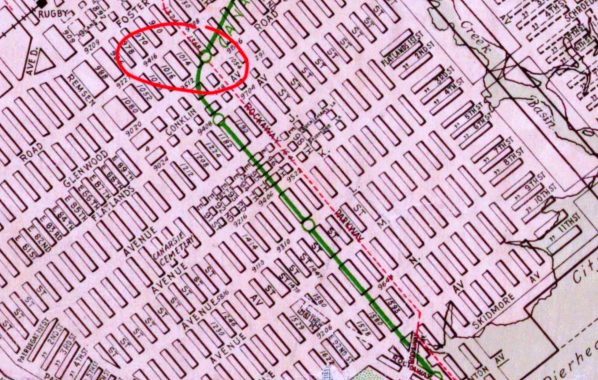
However while you can be excused for thinking that the Canarsie Line has always ended at Rockaway Parkway, there was an approximately 1.5 mile section that has been utterly, er, um, forgotten. Through service on this section south to Canarsie Pier (which featured an amusement park for awhile) continued through 1920, with stops at Flatlands Avenue, Avenue L, and Canarsie Pier, and a one-track trolley line in a separate right of way between East 95th and 96th Street operated as a trolley shuttle until November 1942.
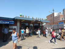
This “Canarsie Shuttle” ran for 22 years even though it completely duplicated a two-way trolley line on Rockaway Parkway two blocks away. That trolley was shut down in 1951, to be replaced by the present B42 bus, which runs between the BMT Canarsie terminal and Canarsie Pier, which has become a substantially large park over the years. A free transfer between bus and subway has existed for decades.
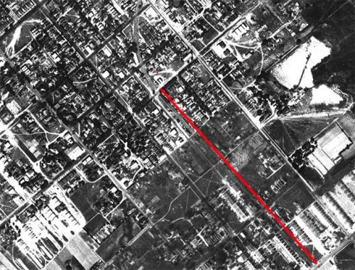
On this aerial shot of Canarsie taken in 1924, I have marked in red the route of the Canarsie Shuttle just east of East 95th Street, and you can see the curving right of way between Rockaway Parkway and Flatlands Avenue on the north end.

That curving right-of-way is still visible on this Google Maps aerial from 2022, though the Shuttle hasn’t run for over 80 years now.

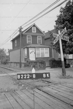
Unfortunately I have no photos of the Canarsie Shuttle in action; a few must exist (are you reading, Bill Mangahas?) However, the line is hinted at in some tax photos from 1940. You can see utility poles along the line at Avenue K and the Shuttle here.
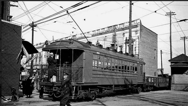
Bill Mangahas ( I religiously acquire his subway calendars every year) came through with this photo of the Canarsie Shuttle crossing Rockaway Parkway north of Glenwood Road. The still-existing Jerry Building is in the background; Armando’s Pizza is on the right side of the building.
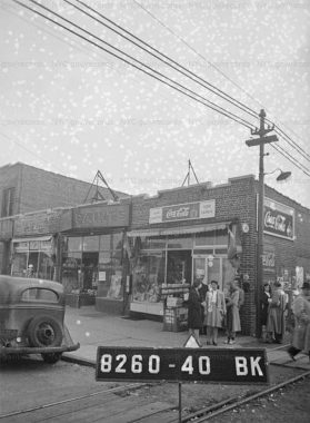
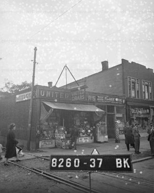
A pair of tax photos from 1940 at Avenue L, along with much of Flatlands Avenue the main east-west commercial route in Canarsie, where the Shuttle had a stop. Naturally there were cigar stores/newsstand close at hand.

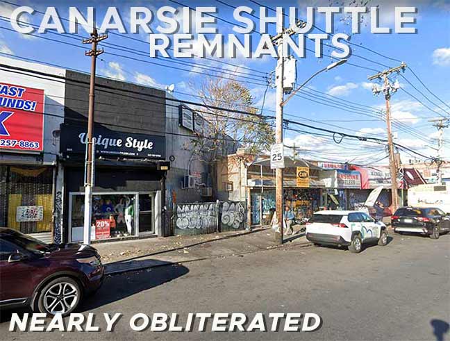
The two low-rise buildings in the center stand atop the old Shuttle right of way today.
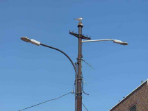
Tangible remnants of the Canarsie Shuttle included, until 1920, some trolley poles at the busway at the Rockaway Parkway terminal. In recent years they carried electric wire and street lighting. In 2020 these were removed and replaced with new streetlamp poles.

On Glenwood Road west of Rockaway Parkway, the Canarsie Shuttle right of way is marked by a slanted building and a tilted trolley pole.

A second pole can be found on the Shuttle right of way as it crossed East 96th Street. To this day the property is still owned by the MTA!
As always, “comment…as you see fit.” I earn a small payment when you click on any ad on the site.
7/8/23

11 comments
The B42 bus free transfer to/from the L train was one of a few locations where NYC subway allowed free transfers to/from a bus route, prior to Metrocards. At Rockaway Parkway the B42 bus entered a private roadway adjacent to the station where a barrier-free transfer was provided, easy to accomplish because the station is at street level. Passengers could transfer between train and bus simply by walking a few feet, the only such location in New York. Other free transfer locations required paper tickets. Metrocard, of course, changed all of this in 1997, when free bus-subway interface became universal.
The Rockaway Parkway setup, where buses enter a paid area adjacent to the subway, is very common in Toronto, where at many locations buses and streetcars stop inside paid station areas to permit seamless intermodal transfers.
It should be noted that the reason for the existence of this route, since its opening in 1865, was for the prior steam railroad to provide transportation to and from Rockaway Park, using steamers to ferry passengers from the Canarsie dock to Rockaway Park. In that sense, it was really a Rockaways railroad, rather than a Canarsie line. When the BRT acquired the ill-maintained railroad in 1906, it must have seen opportunity only in serving Canarsie (after all, there were by then two all-rail routes to the Rockaways), so no ferries for the BRT. Third rail was laid as far as New Lots Avenue, and trolley wire beyond, with its switching power at that point. The as the BRT was rebuilding its lines under the Dual Contracts the third rail was further extended to Rockaway Parkway, but keeping the trolley wire on the rest of the route. It was at this point that through service ended, with a trolley shuttle provided between Rockaway Parkway and the shore from 1920 onward.
Hey Kevin! Two more 1940s tax photos to add. First, a railroad crossing sign on the block (Block 8222, Lot 8) where Canarsie High School now stands: https://nycma.lunaimaging.com/luna/servlet/detail/NYCMA~7~7~775205~639958:9511-Avenue-K?sort=borough%2Cblock%2Clot%2Czip_code&qvq=q:block%3D8222;sort:borough%2Cblock%2Clot%2Czip_code;lc:NYCMA~7~7&mi=15&trs=16 . Second, end of the line at Saint Jude’s Place (Block 8327, Lot 31): https://nycma.lunaimaging.com/luna/servlet/detail/NYCMA~7~7~1028316~636699:Saint-Jude-Place?sort=borough%2Cblock%2Clot%2Czip_code&qvq=q:block%3D8327;sort:borough%2Cblock%2Clot%2Czip_code;lc:NYCMA~7~7&mi=1&trs=2
Thx- added the Avenue K photo.
I lived way down at the “bottom of Canarsie” on E. 92 St. south of Seaview Park. I considered it the “ends of the earth” when the family moved there from East Flatbush in 1968. I got used to it after a while. But it was a long daily commute to/from City College. Twenty-three stops on the Canarsie train to 8th Av. Then Duke Ellington comes to mind as I took the A Train to Harlem. The bus/train transfer was very convenient. It was nice living adjacent to the Belt Parkway, where one could walk or bike along it.
Noting the curve on Google’s aerial view– Property lines can be very conservative, and many an old railroad right of way can be rediscovered like Kevin did here.
Great post as always, Kevin. BTW I researched that line and found a photo of one of its trollies in operation as well as a photo that was banging around the Internet for the Avenue L station – except the station sign read
“Avenue M” (definitely Canarsie line due to an ad for nearby Seaview Terrace. See bit.ly/3D6tUM1
Since the Brighton Line had an Avenue M stop could that be a pre 1906 photo of the Brighton?
Kevin, No. I made that mistake myself. That Brighton station was called Greenfield and then Elm Avenue prior to grade elimination in 1907. Thereafter – and only then was it called Avenue M.
Interesting you mentioning the corner cigar store. United Cigar Stores were on the most prominent corners in every city. Born in 1950, I remember there being about four stores in Downtown Toledo. Great photographs!
If you look further at the aerial view, the ROW of the Canarsie shuttle line is still visible all the way down to Skidmore Ave, in a series of property lines that are not quite square to the street grid.