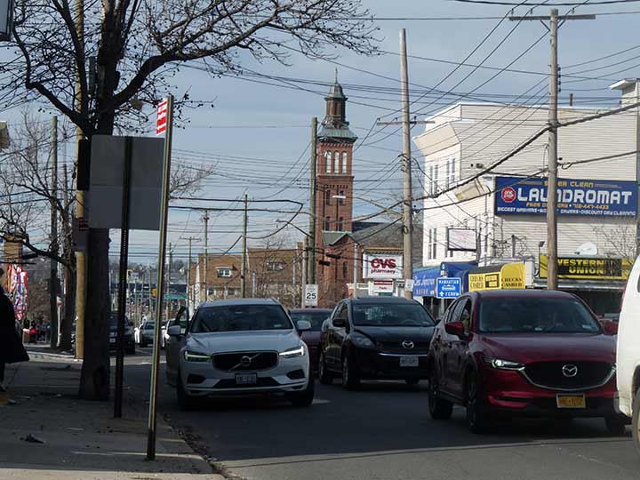
I have visited Rosebank often during over two decades of Forgotten NY. It’s is a pleasant village in southeast Staten Island with tree-lined streets filled with venerable old homes that are gradually giving way to new construction, especially along the old right-of-way of the South Shore Branch of the old Staten Island Rapid Transit. Beautiful views of the Narrows, the Verrazano-Narrows Bridge, and Bay Ridge, Brooklyn, can be glimpsed from Alice Austen and Arthur Von Briesen Parks. Rosebank is anchored by the campanile of St. Mary’s Roman Catholic Church, built in 1857 at 1101 Bay Street at St. Mary’s Avenue, and the slim spire of St. John’s Episcopal Church built in 1871 at 1331 Bay opposite Belair Road. Rosebank, primarily an Italian neighborhood in the early 21st Century, has been home to pioneering photographer Alice Austen and Italian unifier Giuseppe Garibaldi.
In 2020, St. Mary’s was desanctified as the result of poor patronage. The parish merged with St. Joseph’s R.C. Church in Rosebank and Immaculate Conception R.C. Church in Stapleton. Masses and other liturgical ceremonies are no longer held in the building and all sacred objects, such as altars and baptisimal fonts, had to be removed. Unlike St. John’s down the block, the building isn’t under Landmarks protection. The building has been unused since 2015.
Bay Street, meanwhile, is the main route directly connecting St. George Ferry with Fort Wadsworth, now a public recreation area. Formerly, it was one of Rosebank’s “state avenues” along with Maryland and Virginia Avenue, and Hylan Boulevard, formerly Pennsylvania Avenue. Bay Street was New York Avenue and still is, within Fort Wadsworth.
As always, “comment…as you see fit.” I earn a small payment when you click on any ad on the site. Take a look at the new JOBS link in the red toolbar at the top of the page on the desktop version, as I also get a small payment when you view a job via that link.
10/13/23


9 comments
Here’s a Rosebank question. I have heard that during the construction of the Verrazano and the Staten Island Expressway the planners intentionally made the Lily Pond Avenue underpass extra-wide to accommodate the South Beach line should it ever be revived. That seems unlikely to me, however, as when the bridge and expressway were in the planning stage the rail line had been abandoned only a few years earlier, and no one would have intended for it to be revived. Have you ever heard this?
Take it away Andy Sparberg….
Thank you Kevin. It doesn’t make sense that the Staten Island Railway (SIR) South Beach line would have been reactivated when the VNB was being built. The South Beach line closed in 1953, and the bridge construction did not start until 1959. The South Beach was short and normally had single car trains, so it was lightly patronized, especially after 1947 when NYC Board of Transportation took over the island’s private bus operator and reduced bus fares. The line was close to bus routes that connected with the ferries at St. George. Thus, I doubt that rail service to/from South Beach was ever considered for reactivation. The SIR North Shore Line, which also closed to passenger trains in 1953, has been considered for reactivation on and off, even though now that possibility seems remote.
Looking at a street map, it seems more likely that Lily Pond Avenue’s underpass was constructed extra-wide in order to accommodate the significant bus traffic through it, specifically today’s S-51 and S-53 routes, both heavily used. Lily Pond Avenue goes under the SI Expressway near the bridge toll plaza, which when built took away a chunk of the old SIR South Beach line.
Staten Island born-and-raised, have studied all facets of the island’s history. That’s one i never heard, and very, very unlikely. Robert Moses wanted no part of any rail on “his” bridge, so I can’t see why he’d leave a few hundred feet for a ROW for a train spur that closed 10 years earlier. More likely the old ROW allowed for more room to put a few extra feet into the Lily Pond Ave roadway, which makes sense as it’s the first exit off the bridge.
On September 2, 1958 the adjacent Staten Island neighborhood of Rosebank was the venue of a mysterious and 65 years later, still-unsolved and vicious murder. Early that morning Dr. Melvin Nimer and his wife, Lou Jean Nimer were attacked and fatally stabbed by an assailant in their Vanderbilt Avenue home. According to their 8 year old son’s initial account, a masked man attempted to choke him. His parents, rushing to his aid, were stabbed in the struggle. Based on the boy’s description, police issued a manhunt for a white male, wearing blue dungarees and a blue print-striped shirt.
8-year-old Melvin Nimer, was questioned but never charged with his parents’ murders. No arrests were ever made in the case, so it’s still cold.
More information about this case, from http://www.silive.com:
https://www.silive.com/opinion/danielleddy/2018/09/the_nimer_murders_a_maska_hood.html
Today in all likelihood the police would solve the crime in a few weeks thanks to DNA, surveillance cameras and cell phone pings.
Minor error – meant to say “adjacent Staten Island neighborhood of Clifton.” Sorry.
There used to be a big, old building situated on a large property/estate on Fingerbaord Road, right off the Verrazano bridge, walking toward Tompkins. What was that, a convent, a hospital? It’s gone now
Mount Manresa, which was the first Jesuit retreat center built in the United States. The land was sold and the center demolished for redevelopment a few years ago.