

A short lane abutting Bridge Park connects Undercliff and University Avenues near the spaghetti ramps connecting the Cross Bronx and Major Deegan Expressways just south of Washington Bridge spanning the Harlem River, one of the city’s oldest, not to be confused with its bigger cousin, the George Washington Bridge spanning the Hudson. Its name is Boscobel Place; the name means in rough Italian “beautiful woods” and was the name of the estate of William B. Ogden, for whom Ogden Avenue was named.
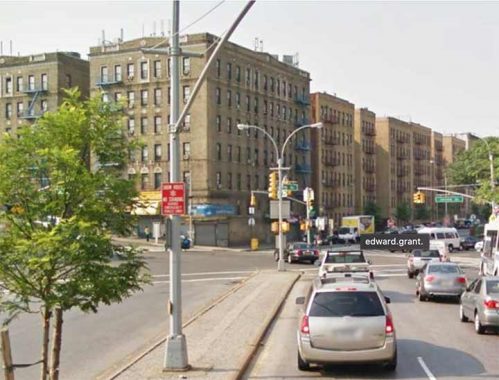
The name “Boscobel” used to be a bigger deal in these parts. Edward L. Grant Highway is one of the few streets in NYC designated “Highway” (Kings Highway is the longest and most famous). Formerly Boscobel Avenue, it was renamed in 1945 for a baseball player, but not a New York Yankee… Edward Leslie “Harvard Eddie” Grant played in the major leagues between 1905 and 1915 for the Phils, Reds and New York Giants, hardly a superstar but a workaday infielder. He was killed at Argonnes, France in October 1918, three years after his baseball career ended. Grant was the first major leaguer or ex-major leaguer to be killed in WWI action. In 1921, the Giants dedicated a plaque in the centerfield at the Polo Grounds in his memory; the plaque is duplicated at the Giants’ present home in San Francisco. I do not know why it took fully 27 years to get around to renaming the former Boscobel Avenue for him.
Grant Highway runs northwest from Jerome Avenue and 167th Street to University Avenue (Martin Luther King Boulevard) where it meets Washington Bridge. The western Bronx strives mightily toward a street grid a la Manhattan south of Central Park, but hilly topography thwarted the effort, and streets meander around willy-nilly.
When I was a kid and started consulting maps, I was perplexed that the western Bronx and Manhattan share the same street numbering across the mighty Harlem River. It was later that I found out that Manhattan, and the Bronx west of the Bronx River, were once the same county (New York County), and when the “Commissioner’s Plan” of a numbered grid originated in 1811 made its way north, all of New York County got the same street numbering, river be damned. Because of the topography I mentioned above, the streets in the Bronx and Manhattan aren’t on the same latitude; for example, when 145th Street is bridged across the Harlem River, you’re on 149th Street in the Bronx. This gets more exaggerated the further north you go, say in Kingsbridge; let’s say you’re on Sedgwick Avenue going north… you jump from 197th to 229th Street. (Because of the way the street grid is laid out, Ditmars Boulevard in Astoria jumps from 49th to 70th Street).
To me, that’s why looking over maps was such fun!
As always, “comment…as you see fit.” I earn a small payment when you click on any ad on the site. Take a look at the new JOBS link in the red toolbar at the top of the page on the desktop version, as I also get a small payment when you view a job via that link.
11/21/23
14 comments
It was known as the “Annexed District”. It was removed from Westchester County in 1874 and attached to New York County. The remainder of what we now call Bronx County, was removed from Westchester County in 1912. It was done to “tidy-up” county lines to align with the boundaries of the consolidated greater New York City in 1898. A similar “tidy-up” was done in 1899 when Nassau County was created from the three towns (Hempstead, North Hempstead and Oyster Bay) that were not incorporated into greater New York City.
Also amazing is how the East and West numbered streets get out of sync within da Bronx itself, as demonstrated on either side of Van Cortlandt Park.
When I lived in the Bronx as a kid, I was at 1115 Jerome Avenue, and attended JHS 82 at University and Tremont. So every morning took the bus up the Edward L Grant to University, where I changed for the north-bound bus. This was when the Cross Bronx Expressway was being hacked through the solidly Jewish neighborhoods, quickening abandonment as whole blocks of buildings were being demolished for Robert Moses’s grandiose cars-and-expressways-are-good-but-old-buildings-are-bad urban renewal ideas. Every day, from the bus, I could see blasting and excavating going on. There used to be a statue of a an on a horse at the foot of University. It was removed by crane one day. No idea what happened to it.
My wife grew up at 174th and Walton Ave. and attended Wade JHS (117). She was living there at the same time, when the Cross Bronx was hacked through the neighborhood. Her building was spared, but next door the apartment houses and some small private homes were razed. She still remembers the noise from the dynamite blasting, 60 years later.
I once lived at 2840 Sedgwick Avenue, on a block bounded to its south by 197th street while just across the roadway to our west was the top of the step street 229th Street.
Another great post. A few more thoughts:
First, let me paraphrase an FNY posting I sent in response to the Nov. 5, 2019 page called “Strange Street Names of the Past.” Boscobel is a historic house museum in Garrison, New York, overlooking the Hudson River, built in the early 19th century by States Dyckman, a Loyalist (pro-British) during the American Revolution. Dyckman was a descendant of early Dutch settlers. His name is forever connected to another NYC street in a nearby part of Manhattan, thus the origin of Boscobel Avenue’s becomes obvious. And I agree that it’s difficult to understand the long wait between Edward L. Grant’s death and Boscobel Avenue’s renaming as Edward L. Grant Highway. Many people mistakenly believe that the Grant being honored is Ulysses, the US Civil War General and 18th President.
Second, like yourself, I too started consulting maps while a pre-teen. I still prefer traditional street atlases to electronic aids. The western Bronx and Upper Manhattan align closely at the beginning, where the first Bronx east-west street, 132nd, is on the same axis as the same Manhattan number. But as you correctly note, the rugged Bronx topography causes the Bronx streets to gradually misalign versus Manhattan.
A little political history plays a part in this misalignment. The Bronx was once part of Westchester County (thus it has Westchester Ave. and Westchester Square). In 1874, the areas between the Harlem and Bronx Rivers, south of Yonkers, became part of New York City (and New York County/Manhattan, as well). The Manhattan 1811 street plan was simply extended across the Harlem River, not always recognizing the topographical challenges. In 1895, the areas east of the Bronx River, all the way to the East River and Long Island Sound, became part of New York City, still part of New York County/Manhattan. The street number system pattern continued roughly the same for the east-west streets, but the misalignment continued as one went further north.
Both areas were originally known as the Annexed District. The Bronx was established as a separate borough in 1898 as part of the great New York City consolidation, but it remained a separate New York State county until 1914.
I agree that the oddball street alignments are what makes looking over maps such fun! I am quite familiar with The Bronx, as I attended NYU’s old uptown campus (now Bronx Community College). Plus, my wife grew up in the vicinity of 174th Street and Grand Concourse. NYU’s campus was at 181st Street, but it overlooked Manhattan at about Dyckman Street, the equivalent of 200th Street.
Finally, another oddball result of this misaligned street system is the east-west street dividing line in The Bronx. That boundary is Jerome Avenue, meaning most of the length of the typical east-west street is in the eastern zone. Jerome Avenue was most likely chosen for the east-west boundary because it is roughly on the same north-south axis as Fifth Avenue in Manhattan.
Up to Kingsbridge Road, the west Bronx streets only go for a mile at the most. North of there, The Bronx swings west to include Riverdale, which continues the Manhattan street number pattern. Thate’s why the north end of the Bronx is at 262nd Street on the west side, while 241st is the limit on the east side.
One correction to my posting above. I wrote:
The Bronx was established as a separate borough in 1898 as part of the great New York City consolidation, but it remained a separate New York State county until 1914.”
Should have said:
“The Bronx was established as a separate borough in 1898 as part of the great New York City consolidation, but it remained part of New York County (Manhattan) until 1914, when Bronx County was established.”
Kevin another example of numbered streets that do not align can be seen in Manhattan. The intersection at West 126th Street and Broadway is a prime example of this, the east side is West 126th Street and the west side of Broadway is West 129th Street. When one looks at a map it can be seen that West 127th & West 128th Streets are not extended beyond Amsterdam Avenue. West 127th Street doesn’t even make it all the way over to Amsterdam Avenue.
The Sedgwick Avenue “jump” is for the Bronx numbered streets between Bailey Avenue and Jerome Park Reservoir to “catch up” to the more continuously (from Manhattan) numbered streets west of Bailey Avenue. Since they do not continue east of the reservoir, you can have a W. 231st Street west of the reservoir and a W. 205th Street east of it.
Looking at a map, you could draw a straight line from W 225 Street to connect with W 197!
Thank you for the explanation of street number discrepancies. Who knew?
https://www.youtube.com/watch?v=hPtQH958vW4
“In his biography of Moses, “The Power Broker,” Robert Caro notes “The great roads of antiquity—the 1,500-mile Royal Road of Persia, the Silk Roads, the Highways of Rome—were built through open country… [The Cross Bronx] was like no other road in history, for it was built through a city.” “Disemboweling a dozen communities along the route,” construction of the highway required the demolition of thousands of apartments in hundreds of buildings in a seven mile swath across The Bronx. In all, over 60,000 were directly displaced by the construction of the Cross Bronx—the most of any single infrastructure project in American history.”
When I was a young boy in Highbridge, my father told me that Boscobel Avenue was renamed due to lobbying by the American Legion. There is a Captain Edward L. Grant Post 1225. It is part of the American Legion Department of New York but I see on the web its current address is in New Jersey,