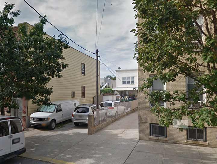
As I have mentioned previously in Forgotten NY, when I lived in Brooklyn , I used to bicycle all over Brooklyn and several times extended into Queens and as far as Valley Stream in Nassau County. From Bay Ridge I would most often go through Bensonhurst/Dyker Heights to reach points further east and while heading down 67th Street between 11th and 12th Avenues, I would go past something that always confused me and to which I don’t have an answer to this day. And, it’s still there.
It’s an isolated trolley pole carrying electric wires to #1160 67th Street, which is considerably set back from the street. I recognized it as a trolley pole, originally carrying overhead wires that powered trolley cars, from its simple cylindrical iron construction and knob at the apex. Until about a decade ago, Surf Avenue in Coney Island still had a couple of dozen.
My theory was that this was an impromptu arrangement and that the pole was rescued from scrap and forced into duty here. There was never a trolley line on 67th Street or a yard; the closest line was on Bay Ridge Avenue (69th Street) two blocks away and there was also another line on New Utrecht Avenue, but nothing close to this location…
Your guess is as good as mine. Comments are open.
As always, “comment…as you see fit.” I earn a small payment when you click on any ad on the site. Take a look at the new JOBS link in the red toolbar at the top of the page on the desktop version, as I also get a small payment when you view a job via that link.
12/23/23


8 comments
It’s very, very probable that your assessment that it is a scavenged pole is correct but it would be interesting to find out if there was an industry nearby that was receiving freight shipments by trolley car. Not unusual before the advent of commercial trucks.
This map here has some dashes in places, I dont think it represents IRT lines, but maybe there was an old ROW there?
https://www.brooklynrail.net/images/historic_maps/Brooklyn-trolley-map-BMT-19.JPG
The pole was not there in 1940, so your guess is the same as mine: https://nycma.lunaimaging.com/luna/servlet/detail/NYCMA~7~7~868229~860533:1160-67-Street?qvq=q:block%3D5766%20and%20lot%3D34&mi=1&trs=4
Doesn’t appear to be in the 1940s photo of the same location. Probably a repurposed trolley pole as you suggested.
https://1940s.nyc/map/photo/nynyma_rec0040_3_05766_0034#17.5/40.626624/-74.005862
Recycling, before it was “cool”? 😉
The house in the back predates the apartment buildings, so my guess is Con Ed and/or NY Telephone had to reroute power lines to the house when the larger buildings went up. Probably bought surplus trolley poles as trolleys were being phased out, first on Staten Island in the 1930s and then Brooklyn in the ’40s. As FNY has posted before, a similar pole near a bus turnaround on Hylan Blvd in SI was located nowhere near any old trolley lines, but was used for electric/phone wires.
There are things beyond our comprehension so we must accept them for what they are
I was not aware of the 1940s map. Thank you so much for the link – amazing stuff.