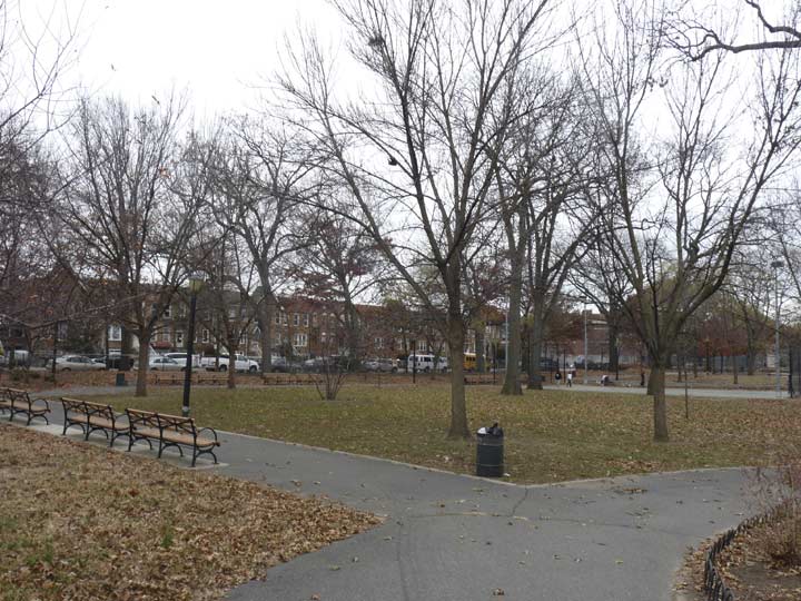
THERE are no less than 20 place names in Brooklyn named “Paerdegat.” There’s Paerdegat Park, shown here; Paerdegat Basin, which separates the communities of Bergen Beach/Georgetown and Canarsie; Paerdegat Avenue North and Paerdegat Avenue South, in the general area of the basin; and Paerdegat 1st through 15th Streets in Canarsie. There’s also the Paerdegat Yacht Club located in Canarsie at the basin. I’m not up on Dutch, so I presume the name is pronounced PAIR-dee-gat, but if I’m wrong, Comments are open. Unlike, say, Amersfort and New Utrecht, there’s no corresponding town in Holland named “Paerdegat.”
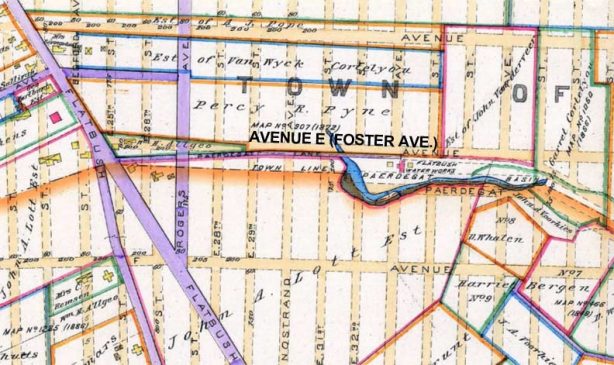
Paerdegat Park, which makes up the entire block between Foster Avenue and Farragut Road between East 40th Street and Albany Avenue, has one of Brooklyn’s Dutchiest of Dutch names, a transliteration of paard gat, “horse gate.” Its original use in Kings County was for Paerdegat Creek, which once ran from about where East 31st Street and Foster Avenue would be laid out southeast into Jamaica Bay. In the 1920s its northern section was filled in and the southern end dredged to make it available for shipping as the Paerdegat Basin, which today runs only as north as Flatland and Ralph Avenues, where we today find the Bureau of Sewers, seen on this FNY page. The land was acquired by NYC for public park use in 1941. You have to use your imagination why there is a body of water named for a “horse gate.” I’m guessing that the farms in the towns of Flatbush and Flatlands had corrals to keep their horses fenced in, and all this was within spitting distance of the creek.

This map from 1890 shows how far Paerdegat Creek once penetrated into East Flatbush. The streets shown in dotted lines in buff were still in the planning stages, with the already existing routes in purple.
As always, “comment…as you see fit.” I earn a small payment when you click on any ad on the site. Take a look at the new JOBS link in the red toolbar at the top of the page on the desktop version, as I also get a small payment when you view a job via that link.
1/25/24


7 comments
It is interesting to ponder how things would have turned out had the Jamaica Bay seaport on Paerdegat Basin actually had been built. It is possible that New York would be an industrial powerhouse today, yet it’s equally possible that the seaport would have become obsolete and fallen into disuse.
When I was a child we would visit my grandmother on E 39th near Avenue D, and my uncle would take us to this park. That would be in the 1970s.
Dutch pronunciation would make the “ae” into something like the “a” in the English word “cat,” and the “g” into something like the “h” in “Chanukah.” If it’s regarded as being Modern Dutch “paard gat,” the double-a-plus-r would be more like a Chicago-accent “ar”.
Incidentally, by the same token (so to speak), if the name of the G-train stop derives from an Anglicization of the Dutch name “Claessen,” it should be pronounced as written, not as “Clawson.”
Paerdegat Avenue South and a companion avenue, Paerdegat Avenue North, were proposed by the Kings County Town Survey Commission, which between 1869 and 1874 laid out the streets in the Towns of Flatbush, Flatlands, Gravesend, New Lots and New Utrecht. Both avenues were to flank Paerdegat Basin, which was a proposed improvement of Bedford Creek by the Town Survey Commission to provide shipping access from Jamaica Bay to Flatbush.
On October 8, 1901, Paerdegat Avenue North and South, and Paerdegat Basin were closed by the New York City Council between East 31st Street and Flatlands Avenue. Interestingly, all that remains of Paerdegat Avenue South extends from Flatlands and Ralph Avenues to the intersection of Avenue H and Glenwood Road. A remnant exists as a turn lane from Glenwood Road eastbound onto East 56th Street southbound, and traces may be found in diagonal building and lot lines between Farragut Road at East 42nd Street and East 45th Street north of Glenwood Road, and on East 37th and East 38th Streets south of Foster Avenue.
The source of Paerdegat Creek is the site of Flatbush Gardens apartments, specifically Nostrand Playground.
A family member lived on one of the Paerdegat streets many years ago. We always pronounced it as “Pay-de-Gate”, but we were probably wrong, as we also said “Van WICK”.
I tried going to find a “0.3 mile hiking trail” once at the nearby Paerdegat Basin Park. Not sure what the NYC Parks website was smoking, the trail didn’t seem to exist in real life and the entrance started in a private road to some boats. The locals told me the trail was wild and pointed me to where it was but it was 100% overgrown, none of us could even see a trail.