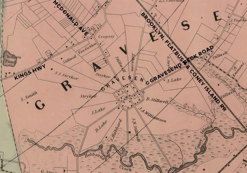
ONE of my favorite pastimes is to pore over old maps, especially of New York City, and note what is still there and what has disappeared. In the mid-19th Century, the mapmaker M. Dripps made beautiful and accurate maps of the New York City area. Here is an excerpt from their Kings County map showing Gravesend, which at the time was one of six towns comprising the county. The City of Brooklyn in 1868 comprised what is now “downtown” Brooklyn, DUMBO, the neighborhoods then called South Brooklyn, Bedford-Stuyvesant, Fort Greene, Williamsburg and Greenpoint, or northernmost Brooklyn. The southern end of the county was rural, or at best, suburban, with farms and open country scattered with small towns connected with steam railroads.
A London widow in her mid-50s, Lady Deborah Moody and her son Henry arrived in southern Kings County in 1643 into territory that was still mostly in Dutch hands after a brutal massacre of the Native Americans by New Netherland Dutch provincial governor William Kieft. She was granted a town patent by Kieft that permitted adherence to any church, a novelty in an age of religious fervor. Lady Moody, an Anabaptist (a sect that rejected infant baptism in favor of adult baptism) found the climate in England oppressive and sailed for the Massachusetts Bay Colony in 1639; finding the Puritans there hardly accommodating, she founded Gravesend in 1643. The vengeful Native Americans destroyed the new settlement before it got a permanent foothold in 1645. Over time, though, a square town plan developed whose layout remains unchanged to this day despite an overall street grid that was developed a good two centuries later.
In this 1868 map, several items are still there besides the square town layout. Kings Highway was developed from a Native American path in the early 18th Century and eventually turned north to the East River; the easternmost section of Kings Highway overlays another old pathway, Old Flatbush Road. Bisecting Gravesend from north to south was a roadway later called Gravesend Avenue and then, in 1930, McDonald Avenue. The roadway leading east to the salt marshes now in Marine Park became Gravesend Neck Road.
The properties surrounding the Gravesend town plan belonged to farming families whose names are still on the Brooklyn map: Stillwell; Lake; Hubbard; Stryker; Cropsey; Lake; Van Sicklen; Voorhies. The railroad called the Brooklyn, Flatbush and Coney Island is today’s B and Q trains.
What has disappeared? Hubbard’s Creek and Indian Pond, which are either filled in or in the sewer system. Coney Island Creek, which made Coney Island an “Island”, was partially filled in, with the easternmost end dredged and now named for a fish that can no longer be caught there, the sheepshead.
Just west of where I cropped the map was the town of New Utrecht, named for a Dutch city, which had its own town center at today’s 18th Avenue and 84th Street. But that’ll be another post.
As always, “comment…as you see fit.” I earn a small payment when you click on any ad on the site. Take a look at the new JOBS link in the red toolbar at the top of the page on the desktop version, as I also get a small payment when you view a job via that link.
3/21/24


9 comments
I lived on the North side of Williamsburg, North 3rd St. and Greenpoint Brooklyn.
Some of the property lines make it look like a spider web.
Sheepshead Bay may be named after a fish, but you’d be pardoned, considering nearby Dead Horse Bay, for thinking it had something to do its possibly having been a slaughterhouse district at one time.
One has to remember is when these maps were made they were at a time when such areas were still rural for the most part and not as much populated as they are today.
Vengeful natives destroyed the Dutch settlement?? I am sorry, but you have it all wrong. The Dutch invaders were repelled by the NATIVES!
I think Frenchy seen too many Billy Jack movies
Actually I’m partial to “Dances With Wolves”
They just demolished two old homes off McDonald Avenue…
The Hubbard House, built in the early 1800s, is on this map and still stands today. It is located at 2130 McDonald and listed on the National Register of Historic Places.
https://en.wikipedia.org/wiki/Hubbard_House_(Brooklyn)