

SATURDAY, April 13, 2024 wasn’t a banner day for Forgotten NY, as I had planned an expedition to Howard Beach. The Q53 crawled along despite a dedicated bus lane on Woodhaven/Cross Bay Boulevard. I lunched at New Park Pizza and while I still like the coal fired crust and tart tomato sauce the pieces seemed definitely smaller. I could have polished off a slice in 4-5 bites had I chosen to do so. I began making my way up Cohancy, which is bridged over the Belt Pakway and headed up Hawtree Street for some adventuring, but the light rain and incessant wind forced a command decision to call it a day. I had about a mile and a half walking, out of a planned four or five, before turning around and taking the crawling Q53 back to Woodside.
But before I did I found something mysterious on Hawtree Street, as Cohancy becomes Hawtree just north of North Conduit. On the right side of the photo, note a pair of telephone poles with standard -issue finned lamp masts and new LED lights. However, there’s no road here, just an open field. Checking Street View, I saw that this clearing is relatively new, as it was cleared from woods a few years ago. (I haven’t been on this stretch in over a decade). I’m completely flummoxed why the Department of Transportation would clear the woods and trees out, and add two lampposts. If you have any idea, Comments are open.
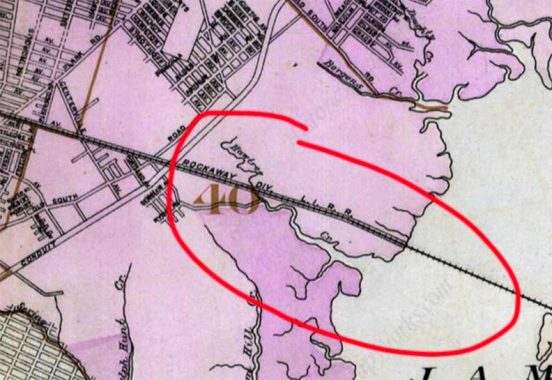
“Hawtree” is a place name in southern Queens, in Howard Beach and South Jamaica. I have circled Hawtree Creek on this 1909 map. In addition, Hawtree Street runs on the west side of the tracks of the Rocakway LIRR, since 1956 the IND A train. Additionally a road that predates the overall grid, Hawtree Creek Road, runs through South Jamaica.
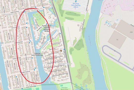
In 2024, Hawtree Creek exists as Hawtree Basin, separating Howard Beach from Hamilton Beach and Ramblersville. Though its meandering course has been altered, it still is more irregular than its neighbors, Shellbank and Bergen Basins.
I used to think the creek and the roads named for it were, in turn, named for a tree or plant (cf. the hawthorn tree) but “Hawtree” is a proper name, and the Hawtree family likely owned property in the marshy ground adjoining Jamaica Bay. It seems to be a British name; in the Beatles’ “Two of Us,” John Lennon invokes the name of British comic actor Charles Hawtrey (who was born as George Frederick Joffre Hartree).
Anyway, who can solve the Mystery of Hawtree Street?
As always, “comment…as you see fit.” I earn a small payment when you click on any ad on the site. Take a look at the new JOBS link in the red toolbar at the top of the page on the desktop version, as I also get a small payment when you view a job via that link.
4/15/2024
9 comments
Possibly to make the woodsy areas less woodsy and brighter.
There was a rape and murder of Kerina Vetrano in Spring Creek park in 2016
https://en.m.wikipedia.org/wiki/Murder_of_Karina_Vetrano
NYCityMap (http://gis.nyc.gov/doitt/nycitymap/template.jsp?z=4&p=991201,192667&c=GISBasic&f=DDC_PROJECTS) inadvertently makes the realignment quite clear: the lot geometry in the area is up to date, but the street geometry is not. Comparing it to Google Maps suggests that Hawtree Street was not only shifted to the west but straightened and extended north to connect to Bristol Avenue.
Sorry, I think my first comment got dropped somehow — maybe rejected as spam for having too many links? I wrote something like this (links removed, and should be read before my comment about NYCityMap):
The lonely poles mark Hawtree’s previous alignment; it was shifted to the west fairly recently. Compare Street View of 150-41 Cohancy Street in June 2018 and November 2020, and on the map layer note the divided green area and isolated Q11 stop marker to the east of Hawtree’s current alignment.
While I can’t help answer your really good question, I can offer something interesting about Hawtree Creek. It was one of several possible southern ends for a never built ship canal that would have bisected Queens. Starting at Flushing Bay and continue down the Flushing River through what is now Meadow Lake and Willow Lake, the canal would have passed trough current Jamaica, South Ozone Park and Howard Beach. It would have entered Jamaica Bay by joining either Shellbank Creek, Hawtree Creek or Bergen Creek. The canal would have allowed ships to pass from the Long Island Sound to the Atlantic Ocean without having to pass through Hell Gate and the heavy East River traffic. A port was intended, which would have rail connections for freight transfer. The port was Broad Channel, and the rail connection was the LIRR, which is now the A train. These were days of grand ideas, and when ships and rail carried everything. Imagine how different Queens (and the City) would be if this grandiose plan had actually been fully executed.
The “time machine-like” feature on Google Streetview tells us this roadway change happened between June 2018 and November 2020. You can see the road (and poles) in their old alignment in the older photos.
A popular trick question is “If the prices are the same, what’s a better deal: (a) two 12-inch pizzas, or (2) one 18-inch pizza?”
Most people say (a) but the correct answer is (b).
Or the other trick question: “Do you want the pie cut into six pieces or eight pieces?” The correct trick answer is: “Cut it into six pieces, as I couldn’t possibly eat eight.”
Yes, 2.25 12” = 1 18”. Easy pizzaman math to compare them too. Just take the size, divide in half, and square. 12” = 36 and 18” = 81 (the 36 and 81 is obtained from the area formula without the multiplier of pi).
In September 2020, I submitted a request for Google Maps for that update to the road shape for 149-57 to 150-43 Hawtree Street, and it was not accepted, although the satellite view was different than the road map view. Yay technology.