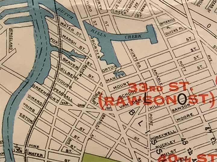
HERE’S a map excerpt I found at a NY Transit Museum exhibition of subway maps in early 2020; it shows the Corona (now the Flushing) and Astoria lines under construction. I may talk about that part of the map at another time, but I’ve decided to excerpt the southern end of the map along Newtown Creek (here, north is on the right, south on the left) to show the wholesale shift in the street names of Sunnyside. As you know if you’ve read Forgotten NY for awhile, in 1915 the Queens Topographical Bureau was tasked with developing a single street naming system for Queens because several of its neighborhoods, formerly small towns, had repeated names, i.e. there were several Washington or Lincoln Streets, and several different street numbering schemes. The new system gave Queens one street numbering system while eliminating dozens if not hundreds of named streets.
Few of the streets leading to Newtown Creek south of Borden Avenue seen here have survived to have their names changed to numbers. Meanwhile, to the right of Borden, most of the named north-south streets received numbers except for Van Dam Street. That street would easily slot in as 32nd Street. Indeed there is no 32nd Street in this section of Sunnyside as the sequence is 31st Place, then Van Dam Street, then 32nd Place, then 33rd Street (the MTA, for tradition’s sake, still has Rawson-33rd on the platform signs). “Van” is a common element in Dutch names, meaning “from the” or “of the.” Originally a Dutch colony, New York City has plenty of “Van” street names, including Vanderbilt and Van Cortlandt. Manhattan, Brooklyn and Queens all have a Van Dam Street.
Of the names on the map the vast majority belong to landholders who sold property to the town of Newtown for building plots and streets. I often wish Queens had retained the old names, but numbering was apparently seen as the best method of numbering streets, as Brooklyn has numerous numbering systems, Manhattan has the one envsioned by the Commissioners’ Plan of 1811 which was continued by the Bronx west of the Bronx River. Long Island City once had its own numbering system which was supplanted by the overall Queens system in the 1920s; for example, 2nd Avenue under the Astoria elevated became 31st Street, and before either number was used, it was formerly Debevoise Avenue.
As always, “comment…as you see fit.” I earn a small payment when you click on any ad on the site. Take a look at the new JOBS link in the red toolbar at the top of the page on the desktop version, as I also get a small payment when you view a job via that link.
4/8/24


3 comments
Honeywell Street still exists as the name of the bridge that crosses LIRR and Amtrak tracks, between 35th Street (south) and 32nd Street (north). 39th Street was originally Harold Avenue; “Harold” is preserved as the name of the LIRR/Amtrak track interlocking tower at the site of the bridge that carries 39th Street over the tracks.
Starr Street is still there as well. You have to make the right on Starr from Greenpoint and make a left on Van Dam to cross the bridge.
What year did Calvary Cemetary expand up to Greenpoint Ave {not icluding the border by 37th st}?