

FINALLY! Your webmaster has come back to the Bronx! It had not been since November 2021 I had set foot in the mainland borough. As many of you know, I was mainly out of action from September 2022 to November 2023, with an undiagnosed hernia that was then corrected with surgery, and then a severe sciatica attack. Both are alleviated for now but I am frightfully out of walking shape. Today, I went 5 miles from Greenpoint past the Navy Yard and was so tuckered I had to get 40 winks when I got home, enabling me to miss watching the Mets blow another one.
On April 20th and 21st, I made two lengthy forays in the Bronx. Today I begin a two-part post describing my walk from Washington Heights into The Bronx High Bridge neighborhood and then back to Harlem. The next day, I walked East Tremont Avenue from Westchester Square to Throg(g)s Neck. Only one walk was in full sun, and it wasn’t the one shown on this page. This spring has been the least sunniest in memory with gun metal gray skies and rain on 13 consecutive weekends. It is now mid-May and has been sunny on exactly three days. I do not prefer cloudy weather for my shoots because the colors are washed out and things look fairly lifeless. Since I work at home all week, until I take a vacation, the weekends have to be when I operate.
GOOGLE MAP: WASHINGTON HEIGHTS – HIGH BRIDGE – HARLEM

If IND subway stations have a design weakness, they all seem to look the same, with tiling, signage, etc. However, when the stations abutted parks in upper Manhattan, subway architect/designer Squire Vickers allowed himself a bit of leeway and designed stone entrances and light stanchions. The green globe has been in place since the 1980s and indicates this entrance/exit is open 24 hours per day. 24-hour service is an innovation of New York: in Europe, most of the undergrounds or metros close at midnight, even in London.


The former Loew’s 175th Street Theater takes up the entire block between Broadway, Wadsworth Avenue and West 175th and 176th Streets. It’s hard to imagine it now when multiplex theaters are the norm and Netflix offers movies at home on flat screen TVs, but going back to the silent era before 1927, movie houses were built as extravagant palaces, as a means of taking people away from mundane circumstances into a different, better world, especially after the country was plunged into a depression through most of the 1930s.
Originally seating 3,444 when it opened on February 22, 1930, the exterior of the building is in the style of a spectacular neo-Assyrian fortress, taking up an entire city block, and has decorative features around the entire building. The walls of the auditorium are embellished with Indo-Chinese decoration, designed by Manhattan decorative specialist Harold Rambusch, which are perforated and have an ever-changing kaleidoscope of colored hidden lights behind. The foyer features a palatial staircase leading to a grandiose, aurora borealis headed by a goddess decoration, all in the style of a gaudy Hindu temple. Cinematreasures
After the theater closed in 1969 (the last feature was 2001: A Space Odyssey) it was the home for many years of the Christ United Church, founded by the charismatic preacher Rev. Frederick J. Eikerenkoetter II, better known as Reverend Ike (his unusual “the pursuit of riches is no vice” message — he charged money for blessings — was a radio and concert staple in the 1970s). Though the church still owns the theatre, now known as United Palace for the Arts, it has become a concert venue hosting concerts by the likes of Neil Young, Allman Brothers, Beck, Smashing Pumpkins and the avant-garde Björk (I know, I sound retro here, I’m 66) and many other acts. Movies have also returned in a limited fashion. Rev. Ike’s organization must be applauded for keeping most of its exterior and interior features intact. The theater also offers tours and movie screenings in addition to music and comedy acts.
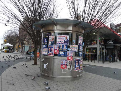
The United Palace proved so popular that to address crowding, West 175th between Broadway and Wadsworth Avenue was demapped to auto traffic. Unfortunately, I don’t know what this abandoned booth’s purpose. Ticket sales perhaps.


About a block south of the theater, at Wadsworth and West 174th, stands the Fort Washington Presbyterian Church, with a distinctive stone tower. The Neo-Georgian building was completed in 1914 and designed by Thomas Hastings of the famed architectural firm Carrere and Hastings, which had designed many of the Carnegie libraries around town, as well as Staten Island’s Borough Hall. It was named a NYC Landmark in 2009. A Hispanic Presbyterian church now occupies the building.

Looking north on St. Nicholas Avenue, named for the patron saint of the Netherlands (Dutch were the first Europeans to make a permanent settlement in the NYC area) we can see the Church of the Incarnation at St. Nicholas Avenue and West 175th. It is a Roman Catholic parish founded in 1908, with both its Gothic Revival church and school buildings constructed in 1928. There is also an Anglican Church of the Incarnation further south on Madison Avenue and East 35th Street in Murray Hill.
For liturgical purposes, the word “incarnation” refers to Jesus, the Son of God’s, assumption of human flesh for his earthly mission. The root word in Latin is “caro” meaning flesh, and it also pops up in the terms ‘carnal’ and ‘chile con carne.’

Juan Pablo Duarte (1813-1876) was the founder of the Dominican Republic, which shares the island of Hispaniola with Haiti in the Caribbean Sea. Washington Heights is heavily Hispanic with a large Dominican population. Duarte’s efforts gained the D.R. its independence from Haiti in 1844; however, he had to flee to Venezuela when he and his followers were defeated in a bid to become the ruling party.

Parking garage, West 174th near St. Nicholas Avenue. These garages used to be built with a lot more panache, but I can say that for most modern architecture.

Since there are so many of them now, I’ve begun to pay more attention to honofic street names, such as Hugo Cabrera Wat at Amsterdam and West 173rd. I’ll let NYC honorific streets king Gil Tauber take it away:
Hugo Cabrera (1953-2021) is considered the best Dominican basketball player of all time and one of the best Latin Americans players He was born in Santo Domingo and emigrated with his mother to New York City where he lived in Harlem until he was 18 years old. He attended Brandeis High School where he was on several All-Star teams, winning him a scholarship to East Texas State University, now known as Texas A & M Univerity–Commerce. His college-level accomplishments included playing 122 consecutive games, a record in force until 2009, scoring 1,458 points and snagging 842 rebounds. He was also the first player drafted by the NBA at Texas State. At the national level, Cabrera participated in many international tournaments. He ended up playing with the Wilkes-Barre and Allentown teams in the Continental Basketball Association (CBA) where he averaged 33.6 points per game. He died on March 23, 2021 in New York City as a result of pancreatic cancer. He was 67 years old.

Having reached Amsterdam Avenue, I’m at the edge of High Bridge Park and its massive pool building, constructed during Robert Moses’ flurry of pool and park construction under the auspices of the Works Progress Administration in the 1930s. A total of eleven pools in five boroughs were built, the best-known being Astoria Pool in which trials for the Olympic Games were held.


High Bridge Park runs along the Harlem River from West 155th and Edgecombe Avenue all the way north to Fort George Hill and Dyckman Streets, and despite the efforts of entertainer Bette Midler, who has been trying to rehabilitate it along with the NYC Parks Department for several years, it stubbornly remains one of NYC’s more dangerous parks in spots.
The park was assembled in pieces for nearly 100 years, as the city acquired various properties along the river; the last chunk was acquired in 1967. It was, of course, named for The High Bridge, which spans the Harlem River across to the Bronx, the oldest extant bridge in New York City.
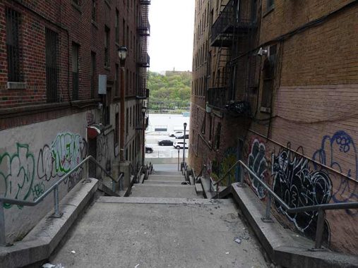
The path to The High Bridge can be daunting to the area novice, especially the steep staircase which can be tough going even when descending. (Channeling Malory, I dub this the Staircase Perilous). A path in Highbridge Park leads close to the river, but the park is on a high bluff overlooking the river. From there, there are views east to the Bronx, but these are best seen in fall and winter when the branches are without foliage.
The High Bridge water tower is a signal that the staircase to The High Bridge is close by. It was built by architect John Jervis a couple of decades after the bridge (from 1866 to 1872) and was used as a 47,000-gallon storage tank and as a water pressure equalizing structure. It has a winding spiral staircase inside whose climb, while a little tiring if you’re not in terrific shape, rewards you with spectacular views of the surrounding Washington Heights, Harlem and Morrisania neighborhoods. The bridge was built as a conduit for water entering Manhattan from the upstate Croton Aqueduct.


The High Bridge is the oldest extant bridge in NYC that spans two boroughs, though when it was built between 1838 and 1848 [John Jervis, arch], the Bronx was still a southern extension of Westchester County. The High Bridge was actually the third bridge to cross the Harlem River: the original Kings Bridge spanning the river was built by the British in 1693 and the original Macombs Dam appeared in 1814; the present Macombs Dam Bridge, the third on the site, was built in 1895. While other Harlem River crossings look fairly uniform — they were designed by Alfred P. Boller, except for the new Willis Avenue — The High Bridge is a beast all its own, with a unique design.
The High Bridge was built as a conduit to water to the city from the upstate Croton Aqueduct. Originally, High Bridge featured massive stone arches (like Roman aqueducts had) for its entire length. The arches survive on the Bronx side, but the steel span was constructed in the 20s to allow navigation on the Harlem River. Water was carried in two 33”-diameter pipes, later replaced by a more massive 90” pipe. It was able to conduit as much as 24 million gallons of water per day. I’ll show the arches further down on this page.
The High Bridge has always featured a walkway, although it never had roads for auto or horse traffic. Edgar Allan Poe, a Bronx resident toward the end of his life, enjoyed frequenting the bridge. The walkway features attractive cast iron hand railings and interlocked red brick paving stones, along with views of High Bridge’s neighboring spans across the Harlem, the Alexander Hamilton and Washington Bridges. These architectural elements are being rebuilt for the bridge’s reopening.
I have crossed High Bridge numerous times since it was officially reopened in 2015. It had been fenced off since 1960, as the local youth insisted on throwing objects off the bridge to menace ship traffic in the Harlem River. It how has a mesh fence to discourage such shananigans. I have better quality photos (taken in full sun) and more bridge information on this 2015 page in which I also walked from Washington Heights and then south in the Bronx.


On the Bronx side, in a neighborhood also called High Bridge, is a terraced area with welcome benches and an embedded compass in the pavement, also called Highbridge Park. Though the best view of High Bridge’s masonry arches is from Depot Place, accessible from Sedgwick Avenue, this park also provides vews of some of High Bridge’s original arches. In 1928, to facilitate shipping in the Harlem River, a number of the arches were replaced by a steel arch span. The replacement is also noticeable on the bridge’s walkway, which switches from straight brick paving to herringbone halfway across.

High Bridge’s arches aren’t exclusive to the area. The Harlem River Drive, on the Manhattan side, is also borne on masonry arches just south of its spaghetti ramp connection with Washington Bridge. Walkers and cyclists made do with the lengthy Washington Bridge before High Bridge was reopened.


I headed south on University Avenue, which in High Bridge looks considerably different from the bustling University Avenue that runs through western Bronx. That’s because it is a different avenue. Prior to 1913, University Avenue below Washington Bridge was called Lind Avenue (possibly in honor of singing star Johanna Maria “Jenny” Lind, the soprano “Swedish Nightingale” who toured the USA in 1850, well before the era of recorded sound). North of Washington Bridge, University Avenue was called Aqueduct Avenue for the Croton Aqueduct, which continues to run through the region and is accompanied by a linear park.
The “university” was the Bronx campus of New York University, which occupied the plot that includes the Hall of Fame for Great Americans, but is now New York Community College. Careful on that campus: seciurity guards have apparently been instructed to keep a special eye out for people pointing cameras at things.
In the 1970s or 1980s (I am unsure) the entire stretch of University Avenue from Sedgwick Avenue up to the Jerome Park Reservior was subnamed for the assassinated civil rights giant Dr. Martin Luther King.
The city has inserted a bicycle-only lane on this stretch, which was narrow enough already, and van drivers unwilling to look for parking spaces go on the sidewalk.


You know me, I present the unvarnished truth. The west side of University Avenue south of the bridge sits on territory apparently too steep to build on (though in hilly northern Manhattan, several apartment buildings sit on iron superstructures on hillsides) and so, the lots are vacant: which New Yorkers believe is a prima opportunity to place garbage. The Bronx leadership should push for a cleanup and a southern extension of High Bridge Park.


In northern Manhattan and the Bronx, the underlying schist rock occasionally surfaces, making for picturesque photo opportunities. The staircase leads to West 169th Street. I often call the Bronx the Borough of Apartment Houses but I can also call it the Borough of Step Streets because of its hilly terrain, as it can compete with locales such as Pittsburgh for step street supremacy.


Highbridge Gardens Houses comprises six high rise towers, built in the 1950s, on a bluff between Sedgwick and University Avenues south of West 167th. If you’re curious this youtube clip takes you inside.

This relatively new building at East 165th Street and University, opened in 2015, is the Nuasin Next Generation Charter School, originally called Metropolitan Lighthouse Charter School. Why “lighthouse”? See below.
West 165th sneaks down to Sedgwick Avenue between two apartment houses on yet another step street.


A look skyward at a building at Sedgwick Avenue and University Avenue) reveals a 30-foot tall lighthouse cast in bronze. It was the home office of the H.W. Wilson Company, a venerable bibliography and periodical index publisher; among their titles are the Readers Guide to Periodical Literature and Current Biography. The company also maintained a voluminous online reference database.
Halsey William Wilson began the indexing publisher with partner Henry Morris in Minneapolis, Minnesota in 1889 as a bookseller. Wilson tired of searching though publishers’ catalogs, and hit on an idea to publish his own catalog of new books that would be constantly updated. Wilson’s first Cumulative Book Index appeared in 1898, and by 1901 had expanded to include magazine articles. In 1911 the company moved to White Plains, NY and again in 1917 to the present location near the Harlem River. In 1929, the eight-story building with the lighthouse was built. The lighthouse, resting on an open book, is meant to “give guidance to those seeking their way through the maze of books and periodicals, without which they would be lost.” At night, the entire structure is lit: in 1998, the company’s centennial, the lighthouse was relit after being out of commission for several years.
The building is presently owned by Prime Storage, which has painted the lighthouse black and imprinted its logo thereupon.


A pair of private homes and an empty lot on University Avenue south of the Wilson Building. As I passed in front of an apartment building on the opposite side, I noticed a brown snake (the name of the species is “brown snake” though they can be gray or green) on the sidewalk. These are small nonvenomous snakes found throughout the northeast. The building super came out and gently placed the snake in the empty lot, where it probably came from. Brown snakes eat small snails, slugs and insects; in fact, their jaws are easily able to crack open snail shells to get to the meat inside.


This unnamed small park, overlooking the Major Deegan Expressway and Manhattan beyond the Harlem River, is found in the “V” formed by Sedgwick and University Avenues. I am featuring it here because it looks exactly the same as it did nearly 30 years ago when I found it while looking for the Wilson Building. The city has completely…er, forgotten it. There are park benches of 1960s vintage or earlier, and the long-burned out post top park lamps may be nearly a century old.
This is another job for your local Bronx representative. Get the park cleaned up, add new benches and lighting, and give it a name.


I have become even more fascinated with pedestrian crossings lately and this catwalk, spanning the Major Deegan from Summit Park at West 161st Street, figured prominently in a Forgotten NY foray in late 1999, when a group of subway buffs including me crossed it to access the old 9th Avenue elevated shuttle tunnel under Highbridge Heights. Tunnel has been sealed and is no longer accessible; ditto the walkway.
The walkway has several anachronisms, including some burned-out SLECO “cuplights” and a Type E park post on Sedgwick Avenue at the steps connecting it with the walkway. South of the walkway is a healthy schist outcropping.


Macomb’s Dam Park, between the Macombs Dam bridge approach road and Jerome Avenue north of East 161st, is named for the nearby Macomb’s Dam Bridge that connects Highbridge Heights with West 155th Street in Washington Heights. The park itself opened in 1899 and, in the past, contained an Olympic-style track; three-time Finnish gold medalist Hannes Kohlesmainen trained here in preparation for the 1912 Olympics.
The park’s distinctive fountain was installed in 1910 and moved to its present position in 1936. It was given a restoration in 2006 and 2007.

The most distinctive building in the shadow of the New Yankee Stadium and overlooking Macomb’s Dam Park is the 1901-1902 American Female Guardian Society and Home for the Friendless, and current Highbridge Woodycrest Center, 936 Woodycrest Avenue. It was constructed to house abandoned and needy children by then-prominent architect William B. Tuthill in limestone, brick and terracotta. It now serves as a long-term health care facility.


Highbridge Heights’ World War I memorial honoring area casualties was dedicated in 1923, the same year the first Yankee Stadium opened, and originally stood in a small park about a mile north at University and Ogden Avenues, where it was pretty much unnoticed. In 2018 the city restored it and moved it to Jerome Avenue and West 161st Street in a more prominent location. According to NYC Parks Department it is one of nine “doughboy” statues located around town.

West 161st tunnels beneath the Macombs Dam Bridge approach past Yankee Stadium. I had never passed here before and didn’t know about the baseball art on the tunnel walls.

Just as the Yankees “christened” the old Yankee Stadium with a championship in 1923, they repeated the feat with the New Yankee Stadium in 2009. In 2024, the usual equilibrium holds firm as the Mets are bad and the Yankees are good.
Next time…crossing the mighty Harlem… into Harlem
As always, “comment…as you see fit.” I earn a small payment when you click on any ad on the site. Take a look at the new JOBS link in the red toolbar at the top of the page on the desktop version, as I also get a small payment when you view a job via that link.
5/19/24
10 comments
So, a van parks on the sidewalk – and it’s the cyclists fault. As.a pedestrian, here is something that you should know. From 2008 to 2021, there have been 1,927 pedestrians killed by cars, and only 12 killed when struck by a bike. Seems like encouraging people to bike, rather than to ride in cars may be beneficial. But, sure, keep on hating cyclists and the infrastructure that keeps us safe.
The van shouldn’t be there: but placing a bicycle lane on an already narrow route contributes to it. Insufficient parking. There’s a garage nearby, but that costs a bit.
Excellent posting. I have two key Bronx connections, most notably my wife (she grew up nearby at 174th and Walton Ave., just west of the Grand Concourse where it goes over the Cross Bronx Expressway), and the university that is the avenue’s namesake (I graduated from that NYU campus in 1969). One minor correction – NYU sold it to CUNY in 1973, after which it’s been known as Bronx Community College.
When I first moved to the Bronx in 1956, I lived on Jerome Avenue across the street from PS 114, and would venture south as far as the little guardhouses on the Macomb’s Dam Bridge, as far east as the Grand Concourse and 161st Street. Weirdly, never went up the steps next to my building, to Anderson Avenue. But did go, often, to the Public Library just up Shakespeare Avenue.
The Mets aren’t bad; they just haven’t been around as long as the Yankees. They’re, um, late bloomers.
The stair in Highbridge tower is easily accessible? I’ve never seen the entrance.
“The High Bridge is the oldest extant bridge in NYC that spans two boroughs”
– Some careful wording there. Is there an even older span that stays within but one borough?
A stone arch bridge in Richmondtown, Staten Island dates from 1845 and spans Richmond Creek. Not sure if it’s THE oldest bridge in NYC, but I can’t think of any bridge within city limits that is older:
https://www.historicrichmondtown.org/historic-houses/2018/7/26/town-bridge
An excellent tour. It’s hard to overstate the damage done to the Harlem River Valley during the 20th century. The Harlem River Ship Canal project that eliminated some of the stone arches from the High Bridge, the construction of the Deegan, and finally the Hamilton bridge and its ramps for the Cross Bronx Expressway. I remember an article in the Sunday News in the 1970s where the writer described the Bronx side of the HRV as “almost completely depersonalized.” One good addition is Roberto Clemente state park, north of where you were for this tour.
My family managed to squeeze in one walk across the High Bridge when I was very small, maybe rising five years old. I always wanted to do it again, so when my dad mentioned at the dinner table that it had been closed, fenced off, to walkers, I was severely disappointed. I never thought I’d live long enough to across it again. I played hooky from work that day it re-opened. No way was I going to miss it, and it was a fantastic celebration.
I hope those small parks you investigated get some attention. The true affliction of the west Bronx, IMO, is poverty and various forms of social chaos. Far more residents own cars, which all need to be parked, than the narrow streets can handle. On top of that, most of the apartment buildings were never great shakes even when new. (There are a few blocks of excellent Art Deco style buildings. Perhaps you’ll describe those in a subsequent tour.)
Anyway, excellent!
Concerning Highbridge Pool, it used to be a reservoir.
I also have an essay on the new parks on the Bronx side of the Harlem River underneath High Bridge.