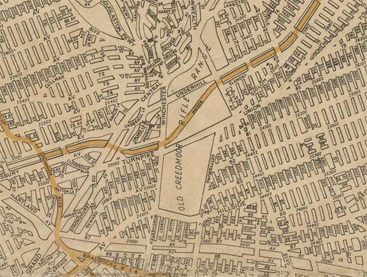
THIS is how Hagstrom Maps, founded in 1916 as a photo reproduction and retouching house that began selling maps a few years later, depicted the Bellerose section of eastern Queens in 1922. Most of the streets in eastern queens as shown here did not yet exist; Hagstrom was representing what developers had in mind. Major routes such as Hillside Avenue and Union Turnpike were still dirt roads at this point in time. Streets were indeed laid out eventually, but they took somewhat different paths than shown here. The Cross Island and Grand Central Parkways were on drawing boards, speculative maps and for the most part, still gray matter in Robert Moses’ brain.
Creedmoor Psychiatric Center is located on the grounds of the Old Creedmoor Rifle Range, deeded to New York State for that use by the National Guard in 1872. International matches were held between American and European teams; the grounds encompassed a clubhouse, railroad station (along the Central Railroad of Long Island) and a local hotel. Bowing to complaints of locals of drunken visitors and stray bullets zinging by, the rifle range closed in 1908 and became a state mental hospital in 1910.
The only vestige of Creedmoor’s shooting days are the names of some of its streets: Winchester, Sabre, Musket, Range, and formerly, Pistol. You might suspect Springfield Blvd. should be included among them, but the road is named for Spring Field, an old southern Queens settlement now a part of Cambria Heights.
Meanwhile, the course of the Central Railroad of Long Island is still well defined by the plot between 87th and 88th Avenue at the bottom of this map excerpt. To this day, there are relatively few places where traffic can traverse this path…where the last train, a shuttle to Creedmoor, chuffed past in the mid-20th Century!
As always, “comment…as you see fit.” I earn a small payment when you click on any ad on the site. Take a look at the new JOBS link in the red toolbar at the top of the page on the desktop version, as I also get a small payment when you view a job via that link.
7/30/24


5 comments
Thank you! I live in Bellerose, and am always interested in its history. Can you suggest a resource where I can find out what Bellerose looked like back then?
Notice how the Vanderbilt Motor Parkway right-of-way is shown in orange east of Springfield Boulevard, and goes through what is now the Glen Oaks apartment complex. Beyond the map , to the right (east), the roadway will go right through property that’s now part of Long Island Jewish Hospital, itself part of the Northwell Health System conglomerate.
I wonder why Pistol was assigned a number while the other streets in this weapons theme kept their names.
Would be neat to have an overlay of old maps with proposed streets on top of what actually appeared there.
An interesting concept map. I lived on 239th Street and 86th Avenue from 1947 to 1959, south of Hillside Avenue from 1947 to 1959. 239th Street in that area also shows up on some earlier maps as Creedmoor Street. 240th Street did not exist. 239th was also the scene of a military plane collision in 1940. The area behind our house was owned by the state and undeveloped, thus the site of many pickup ball games and much kite flying (all pre-Y). The street ended at the railroad spur. We would go to the tracks to see the train, which for part of this time was still steam powered. The wooded area contained a section locally called “The Rockies” which, I believe, was made up of large amounts of concrete left by the demolishing of the rifle range property.