As I recounted on FNY’s Avenue A, Manhattan page recently… Southern Brooklyn uses the Flatbush Town Plan, which was also employed in parts of Flatlands and Gravesend, with east-west lettered avenues and north-south numbered streets called East and West, as they were laid out east and west of McDonald Avenue. The Brooklyn street map evolved confusingly, though; developers such as Dean Alvord, when building areas such as Prospect Park South, preferred to give Avenues A through G British or historic names: Albemarle, Beverl(e)y, Farragut and so on. Thus, as neighborhoods developed independently you have a situation in which Avenues A and B, in East Flatbush where it meets Brownsville, are 5 miles away from Avenue C, in Kensington.
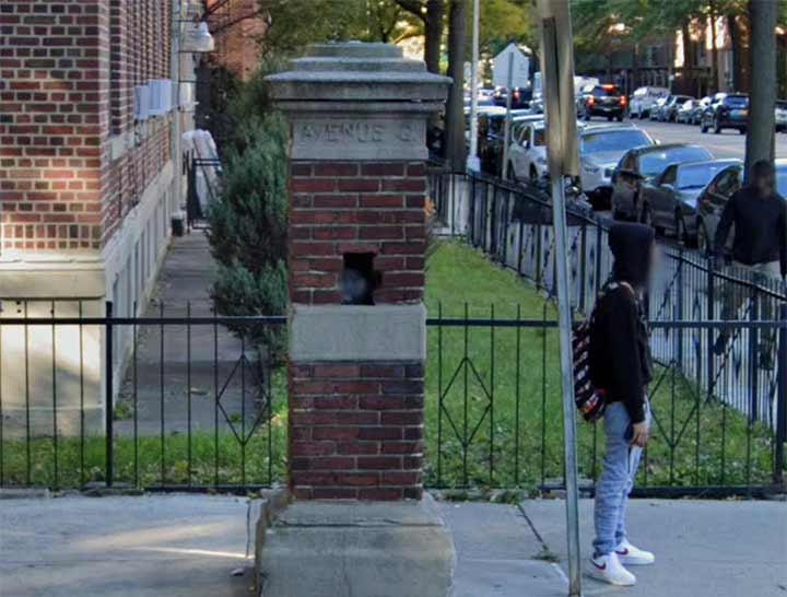
Every now and then, evidence can be seen that Flatbush’s “named” streets were indeed once known by letters alone. There are a pair of brick and concrete gateposts at Ocean Avenue and Glenwood Road that, instead of the latter name, call it “Avenue G” instead. I always thought Glenwood Road was sort of an outlier in the naming scheme, since the A through D avenues employ British-sounding names: Albemarle, Beverl(e)y, Clarendon, Dorchester; Foster Avenue, took over Avenue E. Farragut is likely named for the Civil War admiral, David Farragut. Glenwood, though, sounds somewhat generic.
The gateposts stand on the dividing line between the old Midwood Park and Fiske Terrace real estate developments overseen by T.B. Ackerson. All have been subsumed into the larger Prospect Park South and Flatbush neighborhoods.
As always, “comment…as you see fit.” I earn a small payment when you click on any ad on the site. Take a look at the new JOBS link in the red toolbar at the top of the page on the desktop version, as I also get a small payment when you view a job via that link.
1/13/25


6 comments
I grew up in the Parkville neighborhood and lived on Foster Ave. for a while. I never would have considered it to be Ave. E, since there was an Ave. F just north of 18th Ave, and Ave I just south of Foster. However, I never ventured much east of Ocean Pkwy, into what we thought of as Flatbush.
The renaming of the lettered avenues in the Kensington – Parkville area got a little shifted when some names didn’t match the original letter. So, Avenue D became Cortelyou Road and Avenue E became Ditmas Avenue. Albemarle and Beverley Roads correspond to their original letters, and Avenues C and F retain their original designations, but only in Kensington.
The original section of Foster Avenue (McDonald Avenue/47th Street to Coney Island Avenue) predated the “Flatbush” street grid of lettered avenues, and was named after Charles Foster, a trustee of the United Freemen’s Association, developers of the village of Greenfield, later known as Parkville.
The section east of Flatbush Avenue was originally part of Avenue E. Changed to Foster Avenue east of Flatbush Avenue by ordinance of the City Council, December 10, 1901.
An unusual situation arose at the East Flatbush-Canarsie line at East 56th. Glenwood continues northeast as Farragut while Avenue H continues as Glenwood. Looking at the map, I don’t see why Ave H and Glenwood *couldn’t* have kept their names east of East 56th.
Avenue G was originally laid out from West Street (Dahill Road) to an offset intersection with Flatbush Avenue, continuing east to an intersection with East 56th Street and Paerdegat Avenue, where it was interrupted by the proposed Paerdegat Basin. From Paerdegat Avenue and East 58th Street it continued to an offset intersection with Ralph Avenue, from there continuing to Fresh Creek Basin east of East 109th Street.
Due to the preexisting street grid in Parkville, the original planned section of Avenue G between West Street and Coney Island Avenue was eliminated by 1890, as this was the condition in the 1890 Robinson’s Atlas of Kings County.
Changed to Glenwood Road west of Flatbush Avenue circa 1899, and east of Flatbush Avenue by ordinance of the New York City Council, December 10, 1901.
Would like to see source material for my own research
My source is the 1875 McElroy, Son & Brown map of Kings County. Samuel McElroy, CE was the superintendent of the Kings County Town Survey, which laid out the street grids for New Utrecht, Gravesend, Flatbush, Flatlands and part of New Lots. This map shows the “lettered avenues” pretty well aligned in the Ralph Avenue area, as does the 1890 Robinson Atlas of Kings County. The 1922 Hagstrom Map of Brooklyn, however, shows the alignment as it is today, with Glenwood becoming Farragut and H becoming Glenwood.