

THE west end of Rutland Road in central Brooklyn runs through one of Brooklyn’s most attractive neighborhoods, Lefferts Gardens; indeed the west end is part of a landmarked district, and one of the older ones at that, having been created in 1979. Its picturesquely typed Landmarks Preservation Commission report is still on file. Flatbush Avenue itself is part of Brooklyn’s growing Little Caribbean. If the weather ever warms up, I’ll probably patrol through during my next Prospect Park foray and kill two birds with one stone.
My purpose today is a bit different. I was recently tipped about the McElroy, Son & Brown Civil Engineers 1875 map of Kings County available at the NY Public Library map collection. At that far remove, much of Kings County, which still consisted of a number of different towns that by 1895 had united under the City of Brooklyn banner, was still speculative; i.e. the map reflects what developers hoped to do. Much of it was built according to plan, with the last pieces in Mill Basin and Bergen Beach built up in the 1980s and 1990s.
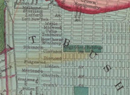 In the title picture, I’m showing the west end of Rutland Road at Flatbush Avenue; the road extends east through a neighborhood known on maps as Wingate (though I don’t know if anyone calls it Wingate) and winds up at East 98th Street and Sutter Avenue, at the west edge of Brownsville. I have left the Google street View watermarks in, as I have said, I haven’t been to Lefferts Gardens lately. If you look at the 1875 map, notice there’s no Rutland Road. Instead, it’s called Tulip Street. The city of Brooklyn decided to change the name to Rutland Road in 1897, as it was likely an overall trend to “class up the joint” by giving streets British names; that’s how Avenue A, B etc. several blocks to the south became Albemarle and Beverl(e)y around the same time.
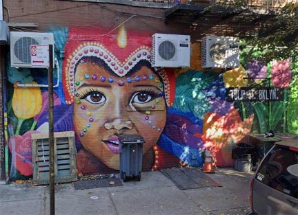
This gorgeous mural at Rutland and Flatbush acknowledges its former Tulip Street status. My proposal: given Lefferts’ Gardens old affiliation with Holland, I propose the Tulip Street name be added back on street signs.
Rutland is a small county in the East Midlands in England, and inspired the name of Neil Innes and Eric Idle’s Beatles spoof, The Rutles. Other area streets had their names changed as well. Malbone (most of it) became Empire Boulevard after the BMT Malbone Street Wreck in 1918. The west end of East New York Avenue became Lincoln Road; Robinson, the east end of Parkside Avenue; Diamond became Lenox Road (in another Briticism); Ridgewood disappeared but is Caton Avenue west of Bedford Avenue; Grant became Snyder Avenue, for a local Dutch family, not the slugging Dodgers star Duke Snider. Lastly, Butler is now part of Albemarle Road.
As always, “comment…as you see fit.” I earn a small payment when you click on any ad on the site. Take a look at the new JOBS link in the red toolbar at the top of the page on the desktop version, as I also get a small payment when you view a job via that link.
1/23/25
1 comment
My mom taught in (George) Wingate High School somewhere between 1960 and 1965.
Wikipedia tells us a lot about George Wood Wingate, after whom the Wingate neighborhood, WIngate Park, and, of course, Wingate High School are named.