VERY infrequently in New York City, you’ll find a Street With No Name. For many years, a roadway way down at the southwest end of Bay Ridge, along Dyker Beach Golf Course and Dyker Beach Park between 7th Avenue and where 14th and Cropsey Avenues come together wasn’t signed by the Department of Transportation for many years, until they gave in and put Poly Place street signs at both ends, extending a previously existing street between 7th and Battery Avenues that was absorbed by the Fort Hamilton army base in the 1970s.
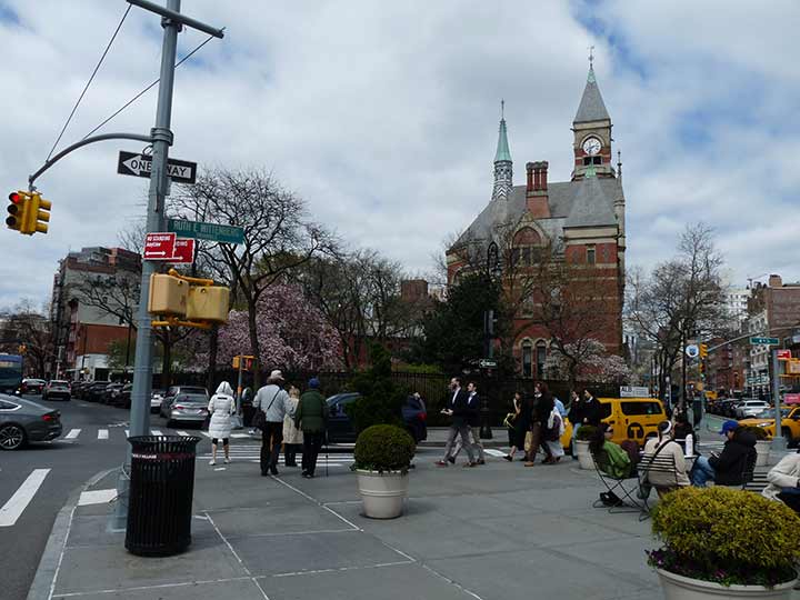
A similar situation exists in Greenwich Village where a small bit of road runs between 6th Avenue and Greenwich Avenue, at the west end of West 9th and the east end of Christopher. Open Street Map is adamant…Christopher Street all the way. Google Maps remains ambiguous, though Street View decides for Christopher. Which is it? In the end it doesn’t matter; no property faces it, as the street forms the south end of Jefferson Market Garden, a tempting bit of green I’m always up for entering but for the two people set up at a table on the Greenwich Avenue entrance, who want me to join something, give them some $$$, or both. It’s a gauntlet!
The Department of Transportation remains ambiguous, as well. On 6th Avenue, there’s a West 9th Street sign mounted on the stoplight, but that could be identifying the street going east: but northbound 6th Avenue traffic can’t turn onto it, as it’s one-way west. On Greenwich Avenue, there’s no street sign, only a sign identifying Ruth E. Wittenburg Square, honoring a local preservationist who tirelessly worked to preserve historic properties in the Village and in getting it named a historic district.
It’s a picturesque location, with the giant Gothic Jefferson Market Library dominating the scene. “Gun to my head,” as they say, I make it part of Christopher. What do you think? Comments are open.
Check out the ForgottenBook, take a look at the gift shop. As always, “comment…as you see fit.” I earn a small payment when you click on any ad on the site.
4/14/25


6 comments
Name it “U2 Street”
When the sign is not stolen, the NYC DOT identifies it as Christopher Street. https://maps.app.goo.gl/cF5XTjnBHY459jAZA As it should be because it fits in with the street grid west of Sixth Avenue.
As of this morning, 4/18/25, there’s a brown historic district street sign saying “Christopher Street” on the same lamppost that has the green W 9 St sign. If you tell me how to do it, I could send you a photo.
Jeez they must have just installed it. No doubt SOMEONE at the DOT reads FNY because when I point out nonstandard signs, they quickly disappear.
If you zoom in using that Google Maps link in your article, it says Christopher St.
NYC Street Map at https://streets.planning.nyc.gov/?bearing=-3.806562219395915&lat=40.7341&layer-groups=%5B%22amendments%22%2C%22citymap%22%2C%22pierhead-bulkhead-lines%22%2C%22street-centerlines%22%5D&lng=-73.9993&zoom=18.65 shows Christopher Street.