DOMINIE’S Hoek (Hook), originally the western end of the town of Newtown, was originally settled when a tract of land was awarded to Everard Bogardus, a Dutch Reformed minister (dominie), in 1643. The land was later owned by British sea captain George Hunter and by 1825 had become known as Hunter’s Point. It began the transition from rural farmland in the 1860s when the Long Island Rail Road built a terminal that would be its primary connection with Manhattan until the East River tunnels and Pennsylvania Station were built in 1910.
Eliphalet Nott, inventor of the anthracite coal stove and founder of upstate (Schenectady) Union College, along with Neziah Bliss, purchased the estate of the Hunter family, which owned much of Hunter’s Point’s territory, in 1835. Bliss set about founding Hunters Point, Greenpoint, Brooklyn, and a small eastern hamlet called Blissville, and laid out the street grids of both Greenpoint and Hunter’s Point, which mirror the grid of Manhattan across the river.
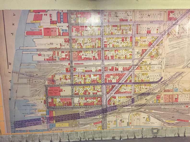
In this map hanging in the Vernon-Jackson #7 train station, you can see the original street numbering system of Hunter’s Point. 1st and 2nd Streets are skipped in favor of Flushing and Borden Avenues.North and south roads are Front Street (corresponding to today’s 2nd Street) West Avenue (5th); Vernon Avenue, now Boulevard; East Avenue (11th St) and Van Alst Avenue (21st).
The dotted lines at the bottom are the underground LIRR tunnels en route to Manhattan. Another set of spur tracks to the north brought railcars to the water’s edge, where stevedores unloaded goods to barges and railcars floated across the river. The Belmont Tunnel shown on the map is in the position of the Steinway Tunnels (built for streetcars, adapted to subways) which run beneath 50th Avenue, two blocks north of Borden.
You can see that the freight tracks at the waterfront were extensive. Today virtually nothing remains of them, except some decorative rails and ties incorporated in Gantry State Park. Warren Chemical, Vulcanite Paving and Standard Oil all had presences on the waterfront. Though some of the old factory buildings remain, Hunters Point and Long Island City are becoming heavily residential in 2024, with tall glass-front towers challenging each other for height supremacy, drawn by river and Manhattan views.
When this map was made, Hunters Point and Long Island were sleepy manufacturing and residential towns. It’s all changed, within the last decade: that’s how fast it has happened.
Check out the ForgottenBook, take a look at the gift shop. As always, “comment…as you see fit.” I earn a small payment when you click on any ad on the site.
4/17/25


1 comment
Of note is the presence of the bridge that continued Vernon Avenue (Boulevard) across the LIRR and Newtown Creek to Manhattan Avenue in Greenpoint, and the absence of the Pulaski Bridge, which replaced it a block to the east, going from from present 11th Street to present McGuinness Boulevard Also absent are the Queens-Midtown Tunnel and the Queens-Midtown Expressway, the beginning of I-495.