

TAKE a walk south on East 15th Street from Gravesend Neck Road and opposite #2305 East 15th, freestanding house, you’ll see a group of 3-story multifamily buildings with balconies and garages on the ground floor. My estimation was that they were constructed in the 1980s, though Google Street View doesn’t go back that far, obviously.
Back in the 1970s and into the 80s, I would peddle pedal all over Brooklyn and even into Queens and Nassau by bicycle, and to my regret I did not carry a camera; I only did that everywhere I went beginning in 1998 or so. I have a camera in my mind, though, and I remember long-gone and forgotten scenes of what I discovered while riding.
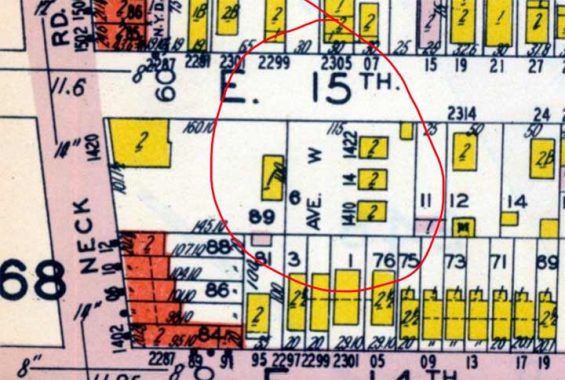
When I bicycled or walked on this stretch of East 15th in the 1970s that grouping of homes weren’t there; instead, there was a pedestrian-only stub of Avenue W with a few houses along it. This stub did not appear on any printed map of the era: Hagstrom, Geographia, Rand McNally, Cleartype or anything else. It was marked by a Department of Transportation street sign.
But I was working in the Brooklyn Business Library when its now-demolished building was in Cadman Plaza West and Tillary Street. And it had a flaking copy of the Belcher Hyde Brooklyn Desk Atlas made in 1929, and when I consulted it, lo and behold there was that stub. The atlas is online at Historic Map Works, which I won’t link because it thwarts screen captures by an automatic zoom when you attempt to do so: but I was able to capture this much of it.
As you can see the three buildings on the stub were 1410, 1414, and 1422 Avenue W. It may have been built by a developer after the bulk of Avenue W was mapped elsewhere. However, this is now a ghost and has vanished entirely; even 1940s.nyc, which shows thousands of 1940s tax photos, is silent on this location.
But the camera in my mind remembers it.
From Comments: The three Phantom Avenue W addresses
Check out the ForgottenBook, take a look at the gift shop. As always, “comment…as you see fit.” I earn a small payment when you click on any ad on the site.
7/30/2025
16 comments
1940s NYC may be silent on the original Avenue W lots, but the municipal archives does have photos taken for the 1980s series. All three are titled as Avenue W, but 1410’s and 1422’s signboards shows East 15 Street addresses. 1414 shows Avenue W.
Since they redesigned the archives site I find it completely impenetrable; that’s why I turned to 1940s.nyc. Can you provide direct links?
This link to Municipal Archives will get you to all three in one shot. And, yes, I agree that the archives are more difficult to navigate since they handed off the front end to someone else.
Try this again. The three homes that fronted on (phantom) Avenue W.
Of all the years you rode your bicycle during that time,about
how many flats did you think you got?
I once walked the bike all the way home from Canarsie, occasionally riding on the rim, with a flat. I had forgotten my money for repairs.
You needed Michael Palin…as Bicycle Repairman!
This may be it, a 1980s view, also a good early image from the 1940s.
https://1940s.nyc/map/photo/dof_3_07399_0089#17.5/40.59465/-73.955884
Reminds me of your August 7th, 2013, entry of THE PERFECT FEDDERS. But that was in Corona.
I would imagine that Kevin meant to write “pedal”, but pesky ol’ auto-correct may have stepped in. Now, the included map snippet notwithstanding, these house numbers also seem to match up with the addresses of the storefronts on nearby Neck Road, so maybe that’s what they were aligning with?
I lived in 2286 E 15 St in the mid 1980s, bet Ave V and Neck Rd, I think I knew a resident of 1 of those Ave W houses, his name was Pete.
your timeline is absolutely correct: i was regularly on that block from 1973-1979, and remember the sign saying “avenue w” and the 3 houses you mentioned. i don’t know what year they were demolished, and i did not kno anyone who lived on that block.
The city’s Department of Finance shows that homes were built on this lot in 2001.
That’s when the three “Avenue W” houses were demolished, replaced by attached homes facing E. 15th Street.
t5hat sounds plausible
I’d say 3 houses were built on the assumption that Avenue W would be extended all the way to E 15th and maybe under the Brighton Line further east like the other avenues. However, from the looks of it, the planning maps were redrawn at the last minute to allow for more lots to be made available to speculators and developers since the area was being rapidly developed into as “Subway and Streetcar Suburb” during the 1920s
1)that certainly sounds plausible
2)does anyone know when houses replaced “thrifty beverage” on avenue x, around the corner from this site?
3)does anybody remember when neck road ran 2 ways, west of ocean av?