

WHILE poring over Open Street Map for something interesting — as one does — I have come upon a complete and utter mystery out of the blue. It’s in Cambria Heights, Queens, of all places. I don’t think I’ve done anything in Cambria Heights except for Old Springfield Cemetery, way back in 2000! It’s a neighborhood of straight grid streets and one-family homes, nothing really Forgotten or unusual. Till now.
According to wikipedia, “The name Cambria Heights was coined in the mid-1920s when the Cambria Title Savings and Trust Company, a bank based in Cambria County, Pennsylvania.” There is a Cambria Avenue in Little Neck, where I live, as well, so perhaps the company did some developing there.
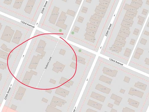
On 133rd Avenue between 225th and 226th Streets, Open Street Map has a “Dubons Lane.” Google Street Maps doesn’t show it, and Street View didn’t photograph that part of 133rd. However, if you look at the aerial view, you can pick out a slanted dirt path I have helpfully circled in red. Additionally, 133-10 226th Street is set way back from 226th Street and may have been built on the alley.

So, what’s going on? This excerpt from a 1909 Bromley Queens atlas may be of help. At the time, 133rd Avenue hadn’t yet been built, but Merrick Plank Road, now called Merrick Boulevard, was already in place. Trailing off from it was an unnamed lane I have also marked here. And, the property was owned by a “J. De Bon”! I trimmed the overhead view above it, but the west wall of the Key Food on Marrick Boulevard is slanted, as if a road once went there. Slanted property lines often mark ancient paths and lanes: and in this case, it may have marked what Open Street Map calls “Dubons Lane.”
Check out the ForgottenBook, take a look at the gift shop. As always, “comment…as you see fit.” I earn a small payment when you click on any ad on the site.
9/16/25
3 comments
The de Bon parcel looks landlocked, so the lane probably was the way that was necessary to get access to “de Bon’s” lot.
About ten years ago I spent several days doing contract merchandising work at that Key Foods. I’d like to say that I noticed the slanted wall, but no.
I believe that location is actually part of Laurelton as I lived in Cambria Heights and had a part time job in a restaurant on Merrick
whose owner called the area Laurelton. Into the late ‘60’s there were a number of un-paved roads in what was then called the forgotten borough. During the infamous “Lindsay snow storm” snow plows did not show up for more than 2 weeks. 120th Ave east of Springfield was rolled gravel, while Francis Lewis between Springfield and 120th was a dirt road. The side streets all had a strip of asphalt down the middle while the parking area next to either curb was dirt.
An area of interest was on I believe Colfax Street at Springfield. It as on the ridge which ran roughly north south, and had cobble stones so horse drawn wagons could get up more easily. The connected garden apartment houses were supposedly built by Brooklyn Union
Gas for their employees.