

RECENTLY, Forgotten New York took a look at three separate street in downtown Brooklyn and DUMBO named Fleet, for an early landowner, Samuel Fleet. I’m not done with lost streets of downtown Brooklyn, though, as nearby there’s another one to talk about. First, let’s take a look at a couple of maps.
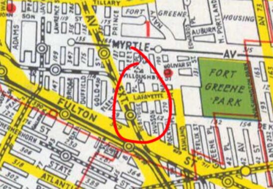
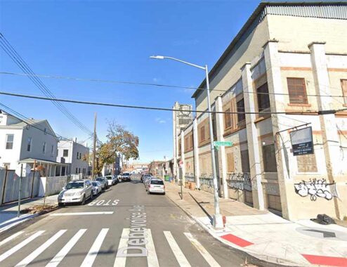
On this 1949 Hagstrom map of downtown, I have circled a small group of streets east of Flatbush Avenue Extension and north of Fulton. In the ensuing years, as we have seen from the Fleet Street page that the modern map is much simplified, as entire blocks and streets have been leveled, mostly in favor of the Long Island university campus and the University Towers Houses. Yet one persists, in an altered form. I’m talking about that short, 3-block route called Debevoise Place.
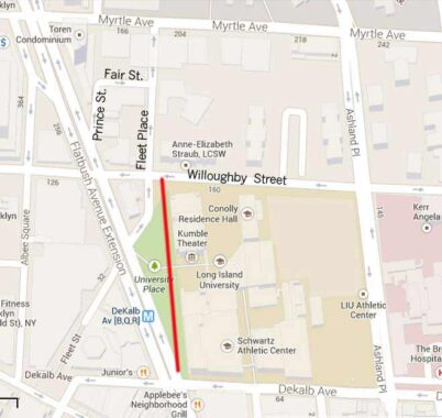
On this newer map, I have delineated Debevoise Place’s former route with a red line.


On the east side of Flatbush Avenue Extension there’s a patch of green marked as “University Place” by NYC Parks, and there’s a sunbleached sign, “University Plaza” on a pole on Willoughby Street. However, Debevoise Place was renamed “University Place” in the 1970s when it was still open to traffic, after Long Island University. When it was pedestrianized, it became “University Plaza.”


These two photos are shot from the same spot, 85 years apart. The 1940 photo is looking south on Debevoise Place toward the Brooklyn Paramount Theater, later to become part of the LIU campus. Photos of Debevoise Place from NYC Municipal Archives
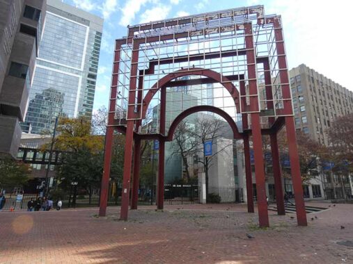
Also from this spot at Flatbush Avenue Extension, we see a couple of buildings along the way in the Brutalist tradition, a very severe style championed by architect Paul Rudolph, among others. One of the hallmarks of Brutalism is that it looks like you could get a severe cut just by staring at the corners long enough.
In this case, the Schwartz College of Pharmacy/Humanities Building actually took an older building and gave it a Brutalist cast in 1967. Alongside it is the steel campus entrance arch, built in 1985.

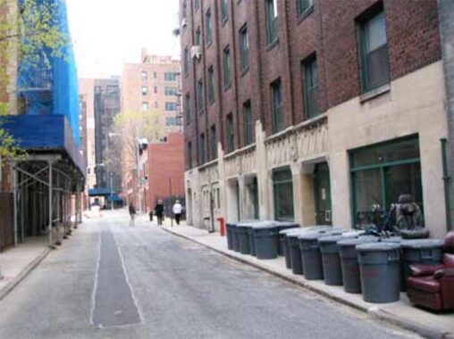
Looking north on the pedestrian-only University Plaza (former Debevoise Place) past a building housing RocNation, an American entertainment company founded by Jay-Z in 2008.


The RocNation building occupies the spot where Debevoise Place intersected Lafayette Street, a short piece of which persisted into the 1980s, so till recently we had two street “ghosts” in the same spot.
Brooklynites likely pronounced Debevoise as (DEBBA-voyz), though in French it was likely more like (debba-VWAHZ). Who was the Place named for? In Brooklyn By Name, Leonard Benardo and Jennifer Weiss are silent about their identities, but relate an interesting story about the family. In Brooklyn Heights, Love Lane runs from Hicks east to just beyond Henry, north of Pierrepont Street. The street was named for Sarah DeBevoise, an adopted daughter of two unmarried brothers of a colonial-era landowning family, who attracted a number of young suitors. “Love lines” in the parlance of the time, were the initials etched by Sarah and her boyfriends on the fence in front of the De Bevoise home. Over time, “love lines” became Love Lane.
We’re not done with the Debevoises. There are no less than two other streets named for the family, but they’re miles away. Debevoise Avenue in East Williamsburg runs in two pieces, from Maspeth Avenue north to Jackson Street, and from Frost north to Beadel, just east of Kingsland. In this view at Debevoise Avenue and Richardon Street, on the right we see what used to be a doll factory, I kid you not.
Meanwhile, here’s Debevoise Street, looking west toward Brooklyn’s Broadway. The street runs for two blocks, from Broadway east to Humboldt Street, just north of Flushing Avenue. Decades ago, half of it was eliminated in favor of the Bushwick Houses. So, even though the city has taken a scythe to different streets named for the Debevoises over the years, they’re still well represented.
Additionally, the street over which the Astoria Elevated rumbles, 31st Street, has been previously known as 2nd Avenue and Debevoise Avenue.
Check out the ForgottenBook, take a look at the gift shop. As always, “comment…as you see fit.” I earn a small payment when you click on any ad on the site.
11/19/25
5 comments
Call up the famous law firm of Debevoise & Plimpton and ask them how it’s pronounced. after all, you’ would figure they would be the authority on the subject, right? 😉
I feel like I remember seeing a Debevoise street or avenue listed as the pre-grid name for a road in LIC, but now I can’t find anything.
31st Street was first called Debevoise Ave. and 2nd Avenue but I’m unsure on the chronology.
The Debevoise family had a large presence in the Maspeth up until the 20th century.
I have a map of Astoria from about 1885. It shows 31st Street as named Second Avenue. It stops at Grand Street( later Grand Avenue, later 30th Avenue). At Newtown Avenue, 31st Street is named Bradford Street.
In a map from the early 1900’s, 31st Street has been cut through from Grand Avenue to Newtown Avenue and the whole length is named De Bevoise Avenue.
What is pretty incredible is the early map has what is marked as a “Horse Car Line” and the later map has a line marked” N.Y. and Queens Co. Ry. Co.” Both of these lines mark the exact route of what was the Q102 bus line up until a few years ago. North on 31st Street, west on 30th Avenue, North on Crescent street, West on Newtown Avenue and then Astoria Blvd. down to the Astoria Houses. The route was changed when the only section of Crescent that was two way ,between 30th Avenue and Newtown Avenue, became one way for a bike lane.