

THURSDAY, November 23, 2017, Thanksgiving Day, dawned sunny and bright. I usually have been at one cousin or the other’s Thanksgiving extravaganza but that year, they were doing it on the weekend, thus I was at loose ends. Perfect photography conditions, though, if I didn’t mind the harsh shadows. So I hatched a plan. Why not link two neighborhoods that have nothing to do with one another with a walk? I arrived at Sunset Park to Maspeth, which would take me through Borough Park, Lefferts Gardens, Crown Heights, Bedford-Stuyvesant, Bushwick, Ridgewood and Maspeth. I walked from the light of day to the dark of night, nonstop (maybe a bathroom break, I forget). To my surprise it totaled only 12-13 miles; I know people who have walked triple that in one walk. It’s 8 years later, and at age 68, my back as well as other parts will no longer permit a nonstop walk like that. It’s not my longest: that was the full length of Metropolitan Avenue, Williamsburg to Jamaica, in May 2015.
I obtained over 300 photos; I won’t use them all but I’ll be splitting this walk into multiple pages to avoid the ever-present TLDR issue. And to make it easier on me.
GOOGLE MAP: SUNSET PARK TO MASPETH
^ Open the map in a separate browser window and follow along with me!


Before crossing into Bushwick, Ridgewood and the remainder of the walk, I was intrigued by this building at the corner of Howard Avenue and Madison Street. In the 1940s tax photo, it has a lot of ornamentation that has since been stripped off and signage identifying it as Swing Club Tavern, with boxing an added attraction. Tantalizingly there is an identifying sign on the Madison Street side, but the Municipal Archives photo is too blurry to make it out. It has since been renovated for rental apartments as The Kopper, with interior photos available here.
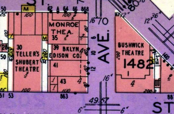
There were once three theaters on one block here: the massive Bushwick, seen in Part Three, as well as Teller’s Shubert Theatre on Madison and the Monroe Theatre at #4 Howard. What killed so many of NYC’s theaters? Television. This was once a lively entertainment hotbed that is utterly forgotten now.
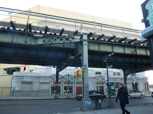
The undefended border of Bedford-Stuyvesant and Bushwick is Brooklyn’s Broadway and its Jamaica Line el serving J trains. The former Bushwick Theatre can be seen on the other side. Bushwick was once a Kings County town on its own, the name derived from the Dutch Boswijck, or “house by the woods.” The town was aborbed by the City of Brooklyn, and then that fish was swallwed by a bigger one in 1898 to create Greater New York.
Bushwick had always been a proudly German neighborhood, but during World War I Bremen Street became Stanwix Street and Hamburg Avenue became Wilson. Bushwick suffered horribly in the aftermath of a citywide blackout in July 1977 when looting decimated businesses along Broadway; lower Broadway, even in the early 2000s, has not completely recovered from that one night and day of decimation. Slowly, however, renewal has begun.
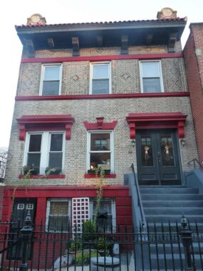
I took notice of #84 Palmetto Street, just west of Evergreen Avenue, because its original ornamentation has been retained. The palmetto is a variety of palm tree found in the US Southeast, but why is a street in Bushwick named for it?
In 1850-51 developer Watson Bowron had surveys and a subdivision map prepared for property including several new roadways in the territory of the Town of Bushwick adjacent to the old Brooklyn city line. This subdivision was known as Bowronville. All of these roadways running somewhat in a southwest to northeast line beginning at Division Ave. (now Broadway) and running to current Evergreen Ave. (part of the old Bushwick Lane) were named by him for trees and vines. The roadways were Linden St., Magnolia St. (now Gates Ave.), Palmetto St., Woodbine St., and Ivy St. (now Madison St.). These names did not duplicate the official names of any existing streets in Bushwick, Williamsburgh or mid-19th century Brooklyn. When these roadways were eventually extended to and beyond the Queens County line, the Town of Newtown in Queens adopted the Brooklyn names for the continuation of these roadways in the Queens territory.


As I mentioned in Part 2, I quickened my pace as sunset was approaching. My digital camera does not do well in the dark but my IPhone does better. I’m attracted to steeples. Skipping a few blocks to Palmetto Street and Knickerbocker Avenue, we have St. Paul’s Evangelical Lutheran Church, with a cornerstone in German. The church was built in 1897 to specifications by prolific architect Theobald M. Engelhardt.


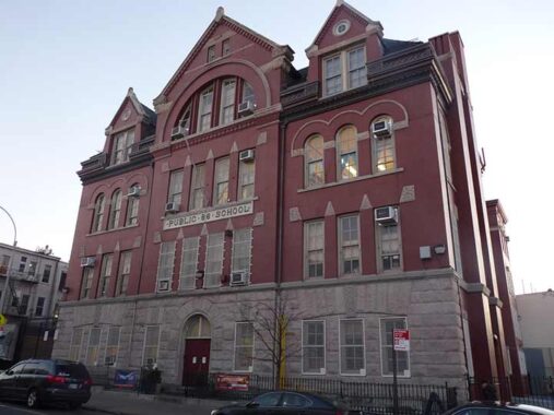
The Golden Hour was in full swing and illuminated PS 116, in flaming red brick, Knickerbocker between Grove and Menahan, Bushwick’s truly great public school building, on Knickerbocker Avenue between Menahan and Grove Streets. It is a brick and terra cotta Romanesque Revival building designed by James W. Naughton and opened in 1899, a year after his death. In 2002 it was named an official NYC Landmark. We will see another Naughton school building in a bit.


The last section of the old Myrtle Avenue el serving Bushwick, Ridgewood and Middle Village was constructed in 1888. In 2017, Bushwick was buzzing about much compromised M service, as the line was being shored up for heavier use, as the L line to Manhattan was scheduled for a 15-month shutdown to repair damage from Hurricane Sandy, but the full shutdown was canceled in 2019. A new plan was put in place to perform repairs at night and on weekends only, using new engineering methods to avoid a complete closure of the Canarsie tunnel. This led to a rift between Governor Andrew Cuomo and NYC subway chief, “Subway Daddy” Andy Byford, and in part led to Byford’s resignation. In 2025, Byford is set to advise Penn Station’s latest renovation, if that ever occurs.


In 2017, I found these murals celebrating baseball’s Roberto Clemente and boxing’s Serrano Sisters, Amanda and Cindy. The Clemente mural has been replaced with a newer one since 2017. I decided to follow Harman Street, as it goes straight to Metropolitan Avenue and points north.
At Harman Street and Irving Avenue is a second James W. Naughton schools masterpiece, PS 88. It is a Romanesque Revival building completed in 1893. Naughton served as Superintendent of Buildings in the City of Brooklyn from 1874-1876, and became Superintendent of Buildings of Brooklyn’s Board of Education from 1879 until his death in 1898. He also designed Brooklyn’s Boys High School and Girls’ High School. All school buildings constructed in Brooklyn during that period were designed by Naughton.
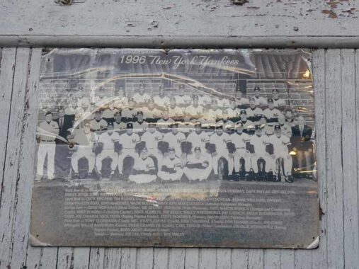
Speaking of baseball, this team photo of the 1996 New York Yankees could be found on a Harman street fence. The ’96 Yanks broke a World Series victory drought of 18 years and kicked off a hot streak of four rings in five years. In 2025, the Yankees have waited 17 years for another.
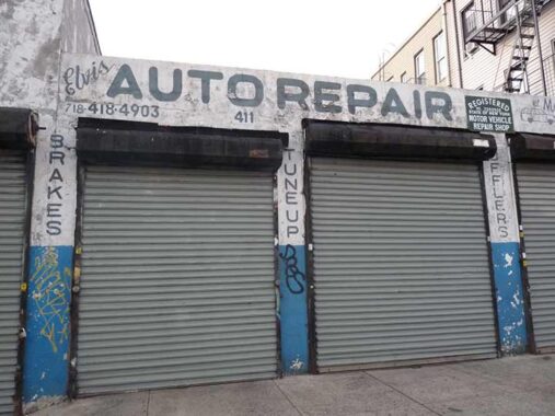
Elvis Auto Repair, #411 Harman Street off Wyckoff Avenue, is still in business.


Since 2017, local taggers have gone to work on this mural by Hugo Andres at Harman and Wyckoff featuring performers seen on Mexican TV and movies, including luchador (wrestler) Mil Mascaras, Cantinflas, pop’s Juan Gabriel and 1970s comic superhero El Chapulín Colorado (“the Red Grasshopper”).


The tidy Ridgewood Pentecostal Church, 457 Harman street off St. Nicholas Avenue, occupies the edifice built in 1928 for the former Wyckoff Heights Presbyterian Church.


We have crossed another undefended border into Ridgewood in the borough of Queens. The towers of Manhattan can be seen from Tonsor Street, as well as Grover Cleveland High School, which occupies almost an entire city block on Himrod between Grandview Avenue and Tonsor Street. The massive edifice was built in 1931. Prominent alumni include longtime New York Rangers and WINS announcer Jim Gordon, actress Rosie Perez, 1950s singer Julius LaRosa and Ridgewood Assemblywoman Catherine Nolan.
Here’s a Crazy Eddie commercial filmed at GCHS, according to legend…
https://www.youtube.com/embed/I_dl2tsuUtc?feature=oembed
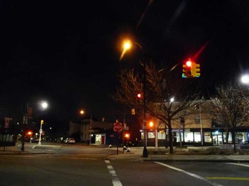
Though this crossroads hasn’t been named, three important roads come together at 64th Street: Grand Avenue, coming east from Williamsburg; Flushing Avenue, which begins at the Brooklyn Navy Yard; and Maspeth Avenue, which is in two pieces in Brooklyn and Queens, interrupted by Newtown Creek.
I have arrived in Maspeth, a neighborhood seeminly stuck between the grit of Brooklyn and the airy, almost suburban feel that its eastern and southern neighbors, Middle Village and Glendalee. Maspeth was first settled by Native Americans for centuries before the middle 1600s and by the Dutch and English after that. After conflicts, European settlers formed a settlement to the east (named, appropriately, Newtown–the present-day Elmhurst).
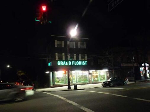
The Queens County Hotel, built in 1851 on today’s Grand Avenue and Remsen Place, served farmers from Long Island who were hauling wagon loads of produce to Brooklyn’s Wallabout Market. The hotel was one of many that sprang up on Grand Avenue, then a farm-to-market road. The wheelwright (above) also served the farm workers. It was a long trip by wagon, and the weary wagon drivers and passengers would stay the night and take a meal, and not a few drinks. The ground floor has housed a florist for many years.
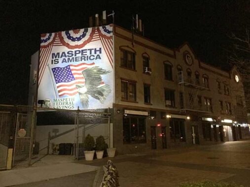
After a walk of about 7 hours, it was appropriate to finish at Maspeth Memorial Square, considered to be the center of town at Maspeth Federal Savings. The square contains war memorials, the town Christmas tree in season, a huge American flag and a memorial to 9/11 victims from Maspeth. Engine Company 288/Haz Mat 1, located just north of the square, lost 19 men on 9/11/01, the most of any firehouse in the city. The town gathered to watch the horror unfold from this site on that horrible day. The site offers a commanding view of almost the entire Manhattan skyline.
Though it was only about 5:30 PM, it was pitch black and everyone was inside digesting turkey and watching football. I caught a Q18 bus to Woodside, where the Long Island RR whisked me back to Little Neck.
Check out the ForgottenBook, take a look at the gift shop. As always, “comment…as you see fit.” I earn a small payment when you click on any ad on the site.
12/3/25
6 comments
Late NY Yankee Stadium public address announcer Bob Sheppard also graduated from Cleveland.
It is not surprising that the Maspeth firehouse had the most losses on 9/11. Because it was some distance away the firefighters entered the South Tower when they arrived and were inside when it collapsed. Many of the Manhattan squads had entered the North Tower, as it was the only one involved when they arrived, and some (not all) of the firefighters were able to escape after the other tower’s fall.
Re: the building at the corner of Howard Avenue and Madison Street, the sign on the Madison Street side likely says “CO-OPERATIVE HALL.” According to Brooklyn newspapers from 1893 through 1916, it was a meeting place for fraternal organizations.
Why is the neighborhood north of Jackson Heights labeled East Elmhurst on the map, while Elmhurst is shown to be south of Jackson Heights?
And Eastchester is south of Westchester County but north of Westchester Square
What do you mean by an udefended border ?