

As Forgotten New York readers know I have an enthusiasm for short streets and alleys, of which New York simply does not have enough, compared to cities such as Philly or Boston. Downtown Brooklyn, however, was formerly blessed with a plethora, especially in Downtown, Brooklyn Heights and DUMBO. Brooklyn Heights has managed to hang on to a few, DUMBO a couple, but Downtown’s have been excised since the 1950s by “urban renewal”: housing projects and expressways that have claimed block after block. In FNY’s early days, after consulting older maps, I assembled a Downtown Street Necrology of the short lanes and alleys we have lost.
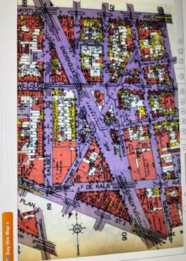
Oddly, among the surviving short streets and alleys, there are a number of streets called Fleet. Here I have excerpted a section of the Belcher Hyde 1929 Brooklyn Desk Atlas from Historic Map Works. Now, HMW does not want you to do screen grabs of many of its maps, including this one, and so the site does an automatic zoom way in tight when I try a screen grab. There’s more than one way to skin a cat and I took a photo of the atlas page with my IPhone and emailed the photo to myself, where I could reduce it to web friendly size, and presto.
In Downtown you have two streets named Fleet, Fleet Street and Fleet Place. Fleet Street is an odd diagonal that runs from Fulton Street and the west end of DeKalb Avenue northeast to the vanished Hudson Avenue, which now longer exists along with most of the streets east of the Flatbush Avenue Extension. A second Fleet, Fleet Place, runs from Fleet and Willoughby north past Myrtle Avenue.
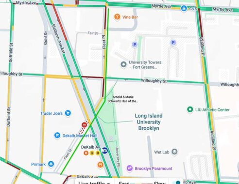
Today’s Google Map is much simplified because of housing projects built in the 1940s and 1950s, Ingersoll Houses and University Towers. However: both Fleets have survived, if not thrived.
I had been under the impression that Fleet Street and Place were named for London’s Fleet Street, formerly the center of London’s newspaper industry (like our own Park Row) and the home of the cannibal butcher of opera and film fame, Sweeney Todd. But I couldn’t be more hopelessly wrong, as Curtis Sliwa says. Instead it’s named for Samuel Fleet (1786-1864), Brooklyn Village’s postmaster, librarian and publisher of the Long Island Journal of Philosophy and Cabinet of Victory, according to “Brooklyn By Name.”
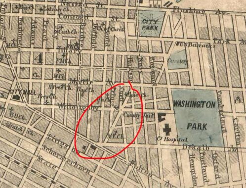
On the earliest detailed map of Downtown I have, the 1852 Dripps atlas of Brooklyn and Queens, the slanted ghost of Fleet Street is in place, though it wasn’t yet known by that name. I don’t know why Downtown had a few slanted streets like this, but they may have led to markets or other gathering places.
[Update: apparently Fleet Street followed the slanted line of Samuel Fleet’s property]


In 2025, the slanted Fleet Street runs past the Dime Savings Bank, now being renovated for retail, and the “supertall” Brooklyn Tower. In 1940 it was lined on both sides with modest dwellings.


At Willoughby Street, Fleet Street ends its run northeast (it continued past it until the 1950s) and hands the baton to Fleet Place. While most of the older buildings in the area have been razed, a hanger-on is the City of New York Department of Health Building, the back end of which is seen from Fleet Street.


In 1940 it looked like an errant lit match could easily burn down some of Fleet Place’s dwellings, but it’s all glassy fronts in 2025.
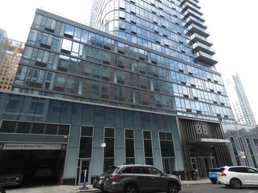
#86 Fleet Place at Myrtle Avenue is a luxury residential tower built in 2015. You can snag a 1-bedroom rental for $5000/m or so. StreetEasy has some interior photos.


Amazingly the narrow alley Fair Street, running one block from Prince Street to Fleet Place, has survived the years. I discussed it in a separate FNY post.


The Giovanni, at #81 Fleet Place at Myrtle, was also built in 2015, and the interiors also look inviting. The corner looked quite different in 1940, when the Myrtle Elevated rumbled overhead, as it would do until October 1969. The preoblem for me is that the immediate area is rather nondescript, and the Ingersoll Houses are, as they say, sketchy.
Fleet Alley
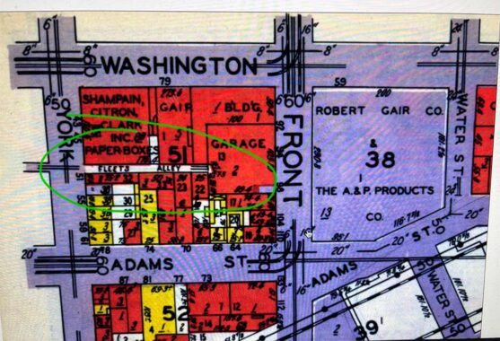


We’re not yet done with Samuel Fleet. About a mile north in DUMBO, there’s the dead-end Fleet Alley on York between Washington and Adams Streets. It now serves as a driveway for the businesses located in the handsome brick Thomson Meter Building, formerly home to Shampain, Citron and Clark Paper Boxes. The gate is usually shut but Street View was by on a day it was open. The Department of Transportation placed a now-sunbleached street sign in the 1980s. In 1929, Belcher-Hyde called it “Fleets Alley.”
1940s photos courtesy 1940s.nyc and NYC Municipal Archives.
Check out the ForgottenBook, take a look at the gift shop. As always, “comment…as you see fit.” I earn a small payment when you click on any ad on the site.
11/17/25
9 comments
Well, at least it wasn’t named for the fellow who started the enema company… 😉
I looked at the list of no-longer extant street names but did not see Vine Street in the far northern Brooklyn Heights, demolished when the BQE was built. I’ve harvested numerous photos of this are of the Heights from the NYC Municipal Archives, a valuable resource. Start here: https://nycrecords.access.preservica.com/?sort=borough%2Cblock%2Clot%2Czip_code
Vine is still there
Fleet Street followed the property line of Samuel Fleet’s property, hence the diagonal position. Fleet Place was formerly known as Carll Street; it was changed about 1870.
Interesting, do you have documentation?
Link to 1874 DeBeers “Farm line map of the city of Brooklyn” from 1874. The street directory shows that the former name of Fleet Place was Carll Street (with two Els). Carll St.runs from Willoughby St. to Tillary.
https://digitalcollections.nypl.org/items/d1578800-c5fa-012f-b72a-58d385a7bc34?canvasIndex=0
The rear side of the Dept. of Health building is… almost… interesting, architecturally. From any other angle? Negative.
The old wooden houses in the 1940 tax photo were certainly grim. But the modern “luxury” towers that stand there today are even more depressing.
Don’t forget Fleet Walk, which runs through the Ingersoll Houses from Prince to Navy St. I am assuming that this “Fleet” has a more naval origin?