

BACK at the end of July 2021, when i could still walk long distance without various pains here and there (I’d like to return to those days) I took a 9 mile jaunt from Victory Boulevard and Clove Road at Clove Lakes Park west along Victory to Willowbrook Park’s carousel, then back along Watchogue Road to Victory and Jewett, where I finally tired and got a bus back to the ferry. I’ve had 167 photos from that day in the kitty since then but have been sort of stumped how to deploy them as there are some very odd buildings that have made their way into FNY over the years, such as the Alba Center, an extremely odd-looking structure at Victory Boulevard and Ingram Avenue on the campus of the Society of St. Paul in Westerleigh. The Society also has a hidden grotto with a number of religious icons.
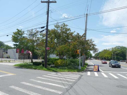
There’s a tidy little traffic triangle at Victory Boulevard, Willowbrook Road and Wyona Avenue that has an odd marker in it placed in 1921 by the Daughters of the American Revolution Staten Island chapter:
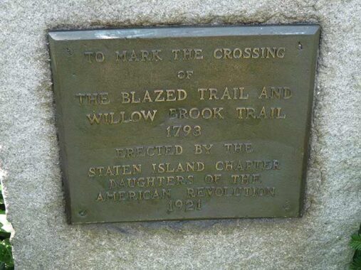
The Willow Brook Trail I take to mean Willowbrook Road itself, with the “Blazed Trail” as Victory Boulevard. Victory Boulevard was conceived of in the 1810s by Vice President Daniel Tompkins as a direct route from the Staten Island shoreline to Philadelphia; horses, wagons and carts would be transported over the Arthur Kill by ferry to further routes through New Jersey south. As such it’s one of Staten Island’s oldest planned roads. Following World War I, it was renamed Victory Boulevard in 1918, at its centennial. The oldest map of staten Island of which I’m aware is from 1874, where this was a crossroads of the only two roads in the area, which at that remote time was mainly grass or farmland. It was also where three of Staten Island’s old towns came together: Northfield, Castleton, and Middletown. By 1917, surveyors and developers had devised a street grid, but as you can see, the planned streets didn’t meet. Planners later connected them, or simply eliminated them for the College of Staten Island (earlier the infamous Willowbrook State School) and Willowbrook Park.
I’m puzzled by what the DAR meant as the “blazed trail.” It’s possible that Tompkins conceived of Victory Blvd. atop a prior Native American trail that was later marked by “blazes,” or colored markings on trees. Staten Island has numerous blazed trails for hikers in its wooded areas; I have hiked some of them.
Check out the ForgottenBook, take a look at the gift shop. As always, “comment…as you see fit.” I earn a small payment when you click on any ad on the site.
1/9/26
11 comments
Oh yeah,feel free to put your yard sale sign right out in the street
Ha! That sign is there semi-permanently. Actually, the Yard Sale seems very impressive. Google Maps (654 Willowbrook Road) even has a street view of it. One of the many oddball charms of Staten Island.
Passed by there every day on the way back to GPO on the 1417 route.
Very interesting
Sadly, my only memory of Willowbrook is the expose of the Willowbrook Staye School for chidren ad adiukts woth intellectual and developmental disabillities. It was done by the journalist Geraldo Rivera in 1972. It led to closure of the institution and was the pivotal moment for the beginning of the campaign for the civil rights of disabled individuals
Do you know what is currently on the site of the defunct institution??
College of Staten Island.
I know the building that you are talking about – I have always thought of that architectural style as “Brezhnev Modern”. Those exterior staircases are just plain wacky.
I remember when Geraldo and a inmate’s dad ‘stormed the Bastille’ at Willowbrook
by scaling a chain link fence and then confronting the head of the place.Very
dramatic when he could have just gotten in by going to the front desk and signing his name
in the visitor’s book
Geraldo was always deamatic in his reporting.
I believe DAR is daughters of the Revolution
If you are walking on a roadway, or a path, the route is rather straightforward. A well-worn pathway that has eliminated the groundcover may be obvious. There might be wagon tracks, or horse tracks, as well. A lesser used trail, however, may not so easy to follow and may seem to disappear. To help the traveler, or hiker, the trail might be “blazed”. On modern hiking trails, it is usually a rectangular line that has been painted on a tree or rock. The line points you in the direction that the path takes. It may be down a slight hill, or through some rocks, but the next “blaze” should not be so far away that you can’t find it by some observant looking. A modern day hiker may come across a point where two paths cross and the blazes would be in different colors so you know how to follow your path, or to change to another one.
In older times, the method of blazing was to notch trees where we will now use paint. The first person to create the trail, and to “blaze” it, would be a “trailblazer”.
When I was in college during the late ’60’s I worked for four summers as a recreation counselor, and also as a classroom aide for those classified as “educable.” Back then people who had an autistic child would often institutionalize them in a place like Willowbrook. There were also kids who were “slow” because of lead ingestion. The ones I dealt with were not profoundly mentally disabled. We went on field trips, to places like Turtle Back Zoo (which is still there). I could take 5-6 kids for a walk over to Wilowbrook Park to feed the ducks. There was a softball team that would play kids from other State Schools. The kids really seemed to welcome the college kids each summer. Having said all that, there was a bit of a dark side to the place where the inmates (employees) were running the asylum. I never saw it, but I heard stories of abuse by employees, and a lot of supplies were pilfered. Fresh linens delivered to the building would disappear pretty quick. Geraldo did expose some terrible conditions in some buildings, but was over the top dramatic. Some of the buildings are still there being used by The College of Staten Island.