
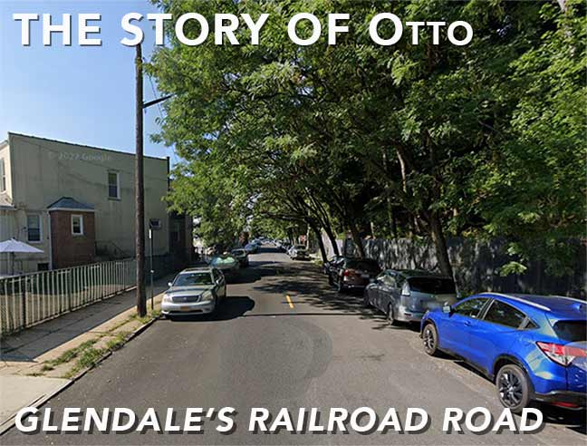

By PATRICK O’CONNOR
Forgotten NY contributor
I’m the type of person who will take the first available spot and walk a while, rather than circulating around looking for a close-up spot and first found Otto Road many years ago when attempting to park near Fresh Pond Road and Myrtle Avenue.
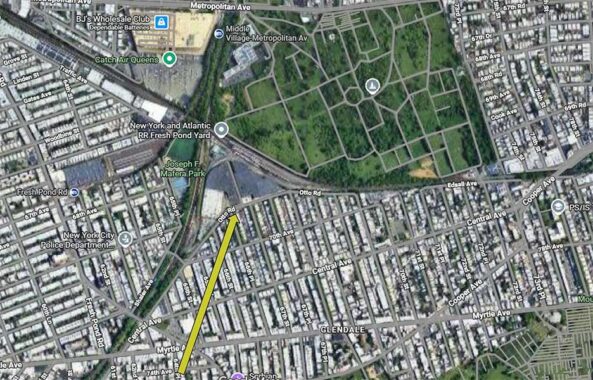
Otto Road runs for 0.6 miles, in Glendale, between the intersection of Cypress Hills Street and Central Avenue to 69th Place and forms the southern boundary of the Fresh Pond Junction where the LIRR Lower Montauk Branch, operated by New York and Atlantic Railroad and the Bay Ridge Branch/New York Connecting Railroad (NYCR) tracks cross.


The intersection of Cypress Hills Street and Central Avenue is complex with the various angles and with 64th Street and Otto Road shooting off in different directions. 64th Street runs just one block south to Myrtle Avenue. Central Avenue continues westward one more block to Myrtle Avenue. Cypress Hills Street continues to the northwest, under the Bay Ridge Branch until it merges into Fresh Pond Road.


On a recent summer day, I had some time in the area and spent it exploring Otto Road in more detail. My first stop, however, was on the stub of Central Avenue between Cypress Hills Street and Myrtle Avenue. Noteworthy here is the interlocking concrete block retaining wall for the embankment of the rail line. Timing was good and I was able to catch a freight train in service. An interesting notch-out in the retaining wall and fence is located near Cypress Hills Street, possibly to store containers for litter pick up and collection.
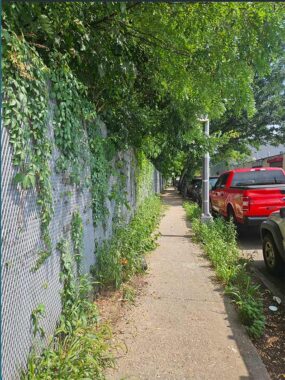
Otto Road appears to have been at least partially built as a railroad access road in the 1920s. Its first block, east of Cypress Hills Street, has a narrow sidewalk and not well kept. The embankment in this area apparently doesn’t need a concrete retaining wall and a heavy gage security fence stands to prevent unauthorized access to the tracks. Across the street was mixed with auto body and car wash establishments and a refurbished building now housing a Law Office. Otto Road changes to from one way-east bound to two ways at 64th Place. A nicely kept residential neighborhood began on the east side of 64th Place, south of Otto Road with a mix of row houses and semi-attached. Very typical is the changeability from light industrial to commercial to residential within a short distance.
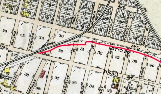
This Queens map published in 1909 shows that the railroad junction is yet incomplete. The route Otto Road was built on is indicated in red, and was likely built as a side access road to the junction tracks. Edsall Avenue was replaced by 70th Avenue, except for a short section further east at the former Glendale station at 73rd Street.
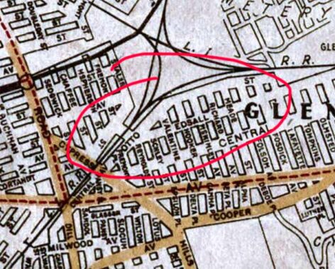
The road has been mapped by 1922, but was called Otto Street. Why the change? Perhaps a clerical error.
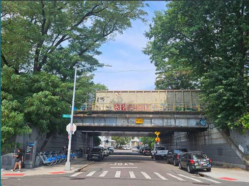
Crossing from Glendale to Ridgewood or Middle Village isn’t easy due to the presence of the tracks and cemeteries. Fresh Pond Road and 80th Street provides the only north-south connections from Metropolitan Avenue to Myrtle Avenue. 65th Street sneaks under the railroad tracks connecting this part of Glendale with the neighborhood east of Fresh Pond Road. We’ll come back to 65th Street shortly.
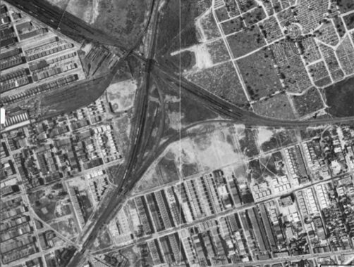
Comparison with this aerial photo from1924, the 1909 map, and current aerial photos indicate that the configuration of the rail complex has changed. The original looks to have been a round robin type of interchange between the Lower Montauk, Bay Ridge Branches and the New York Connecting Railroad. Through service from The Hell Gate Bridge and Bay Ridge began in 1918.
Also in view are the southern portion of All Faiths Cemetery, Fresh Pond Yard and Farmer’s Oval, the predecessor of Mafera Park. Reconfiguration of the round robin, presumably in the 1960s, was made to allow for construction of three single story warehouse buildings north of Otto Road between 65th and 68th Streets. Buildings known as 66-31 and 66-35 Otto Road were constructed in 1970 and the third building, known as 67-25 Otto Road, was constructed in 1994.


The westernmost building houses a Retro Fitness Center and the other two serve as logistics centers. Peering into the warehouses shows materials for supporting film shoots. One of the two gated entrance roads to the railroad complex exists between 65th and 66th Streets allows for a look in.
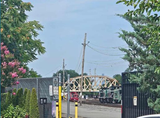
Luck was on my side again when I got to the secured gate at 68th Street. It just happened to open to allow a vehicle to exit, presenting me with a clear shot of the steel truss bridge of the NYCR crossing over the Lower Montauk Branch. I needed to wait for traffic on Otto Road to clear before snapping the picture. I almost missed it but thankfully got it before the gate fully closed!
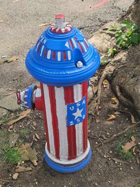
Otto Road ends quietly at an “L” intersection at 69th Place. Folks around 69th Place have the America 250 spirit and painted up their hydrant accordingly.
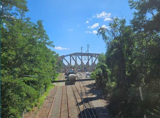
On the way back, I still had some time, so I decided to take the trip up 65th Street to Mafera Park in search of a bonus picture of the steel truss bridge. Formerly known as Farmer’s Oval, the park was renamed after Joseph F. Mafera, who lived in Ridgewood and held several public positions including Queens Parks Superintendent and served briefly as Interim Borough President in 1951. I opted not to take any pictures there as groups of day camp kids were using the park. I wasn’t able to get a view of the bridge due to the trees in bloom. However, a quick jaunt on the M Train from Fresh Pond Road to Metropolitan Avenue got me the view I wanted.
So, who was Otto Road’s namesake? It seems to be a mystery but possibly harkens to someone in the local German American population or a railroader. Comments are open if anyone has information on its naming.
Patrick O’Connor is a lifelong resident of Queens, retired with 40 years of service for City of New York Department of Environmental Protection and is a licensed sightseeing guide in New York City.
Check out the ForgottenBook (HarperCollins, 2006), as well as Forgotten Queens (Arcadia, 2013). I also have a chapter in the anthology “New York Calling: From Blackout to Bloomberg” (Reaktion, 2007). As always, “comment…as you see fit.” I earn a small payment when you click on any ad on the site.
8/31/26
5 comments
Family history has it that Hank Behrman, a Ridgewood resident who played for the Dodgers, and other teams in the late 1940’s, hit a ball off of the steel truss bridge in the photo during an exhibition game at Farmers Oval in about 1940 or 41.
A pretty good shot for a pitcher.
It is likely that the Otto Road/Otto Street difference was not an error, but was quite intentional. Map companies of the time often made such small changes as their way of protecting their copyright. To a person who was looking for an address on a rather short, uniquely named, throughfare it would not have made much of a difference in finding their way. However, if a second map company used the intentional “error” in their own map, the first company was able to show that the second one simply made a copy of theirs, thus infringing on their copyright. It is an old, but simple, trick.
However, “Otto Street” turns up on more than one period map. I’m showing just the 1922 Hagstrom.
FWIW: It was no accident . . . . .Brooklyn Daily Eagle. 05-06-1906, p.6, col. 7. The article is entitled “Streets in Queens Named.” It reports that the street adjacent to and on the east side of the LIRR extending from Central Avenue to Edsall Avenue is to be known as Otto Street. Any mention of “Otto Street” seems to disappear after 1929. Articles begin to mention “Otto Road” in 1928.
There is an MTA contract out to replace the bridge with a simple girder bridge.