
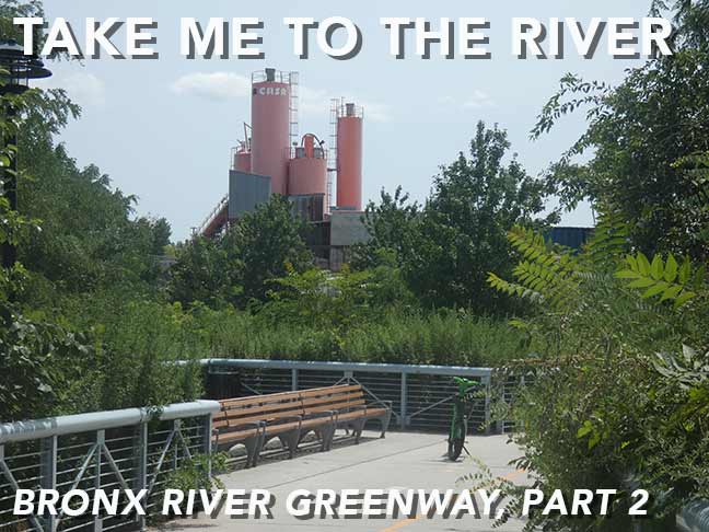

REALIZING that it had been awhile since I had been in the Bronx (a shamefully deficient aspect of Forgotten NY I am always meaning to correct) I decided to explore a relatively new section of public parkland alongside the Bronx River encompassing parts of Starlight and Concrete Plant parks. Though most people visit for the greenery and tranquility, there’s also plenty here for the infrastructure buff including some brand new bridges as well as some very aged ones. This section of the Greenway was opened to the public in 2023, joining previously opened sections. I was there on City of Water Day in late July in the dead dog heat, but nevertheless had a very manageable and enjoyable trip of about three miles total.


GOOGLE MAP: BRONX RIVER GREENWAY — STARLIGHT — CONCRETE PLANT PARK
At the conclusion of Part 1, I had attained the East 172nd Street bridge taking pedestrians and bicyclists over the Amtrak tracks, which in a few years, it is hoped by 2030, will also transport Metro-North trains to the northeast Bronx as part of the Penn Station Access project. The Greenway continues, this time on the eastern side of the tracks, a couple of more miles to the south.
There is some attractive cobblestoning on the sides of the path just south of 172nd Street. I also noticed the “Weight Limit 10 Tons” sign, which must be for emergency vehicles, as this is strictly a path serving walkers and bicycles.


The Greenway passes Westchester Avenue, where a pair of truss bridges, one over the Bronx River, the other over the railroad tracks, transport the elevated #6 line, which runs from Pelham Bay Park south to the Brooklyn Bridge station in Manhattan, where it runs beneath Lexington and Park Avenues and Lafayette Street. There must be other instances where a subway employs a truss bridge (Jamaica Bay perhaps) but I can’t think of any offhand. Help me out in Comments. The elevated needs to climb over the Bronx River at an elevation to clear tall-masted vessels.


The city purchased a parcel at #1237 Bronx River Avenue, formerly a driveway of an auto parts dealer, and converted it to a pedestrian and bike path to the Greenway at a bend in the Bronx River, allowing a glimpse of its wetlands as noted on the plaque.


The Greenway is bridged over the Bronx River at the bend, and once again runs on the west side of the river going south. The 2020s-era pedestrian bridge presents quite a contrast to the Amtrak railroad bridge, which is incredibly rusty yet stable. The bascule bridge was constructed in 1907 as a drawbridge able to raise as need to let vessels pass, but as commercial ship traffic lessened, one of its original three spans was removed and the remaining two left in place.
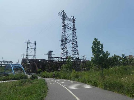
Another legacy of the Bronx River’s former busy ship traffic is the power wires running alongside the railroad being highly elevated on their stanchions to allow ships with tall masts (originally wooden sailing ships!) to safely pass.


For the same reason the #6 elevated is also raised here to a great height, carried over the railroad and Bronx River on truss bridges. Here the Greenway path ascends to street level, and patrons must cross Westchester Avenue using a stoplight to continue into Concrete Plant Park on the south side.
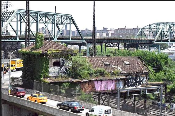


Unfortunately, I can never get to the long-abandoned Westchester Avenue station built for the New York, New Haven and Harftord Railroad (now since assumed into Amtrak after a number of mergers) at an optimum time for photographyE—it’s always in ebony shadows, or in reflected sun glare at the height of summer. Most of the station house still stretches over the tracks as it did until passenger service was abandoned in 1937.
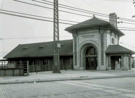
The station, whose architect was the famed Cass Gilbert, dates to 1908 and features a lot of the ornamentation that marked public buildings at this time, with foliage, torches, wheels, and a mysterious target-like device. The top of the stylized torches bear the letters NYH, which probably stand for New York and Hartford.
Unfortunately, though the MTA plans to add a new local Metro-North station at this location within the next decade, it does not plan to rehabilitate this building, which like the Hunt’s Point station (see below) is far gone. Instead, a new station will be built from scratch (I do not know the location). Since the old building does not have Landmarks Preservation Commission protection, it’s under the gun and the new station may well be built in its place.


South of Westchester Avenue, the Greenway path continues, but we’re no longer in Starlight Park. Instead, we enter what has been known as Concrete Plant Park since 2009. But before I get to that, I noticed something different about the park path. It’s lined with standard issue telephone poles supporting electric and phone lines, and they support the finned-mast streetlamp masts found on NYC streets. It made me suspect that this was once an actual street.

Indeed, a peek at a 1922 Manhattan-Bronx Hagstrom map shows that Edgewater Road once ran along the Bronx River in this spot. Still a very busy road today running past still-extant concrete mix plants, Edgewater Road was relocated a bit to the west when Sheridan Boulevard (né Expressway) (I-895) was built from 1958-1963, and serves as its eastern service road.
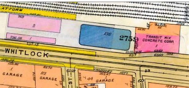
AG. W. Bromley & Co. 1940s atlas shows the concrete plant. According to the AI robot, “Transit-mixed concrete (also known as truck-mixed or dry-batched concrete) is a type of ready-mixed concrete where the raw ingredients—cement, aggregates, and sand—are loaded directly into a truck-mounted rotating drum at a batching plant.”
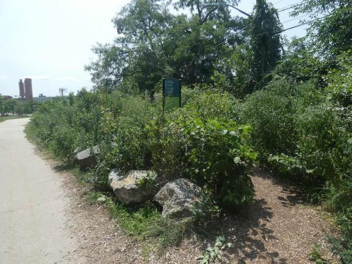
Here we are at the peak of summer in a heavily-green Concrete Plant Park. The toxic chemicals in the soil have been sufficiently eradicated so that the park can support food plants:
“The Bronx River Foodway is a pilot project at Concrete Plant Park developed by NYC Parks Department in 2017 to examine how a sustainable food landscape can be integrated into a public park. The goal is to jump-start the imagination and think about new ways to use land within the city.
|
Currently the Foodway offers access to a variety of edible plants including medicinal plants like echinacea, nut trees like the chestnut, an assortment of native berries, as well as a section dedicated to kitchen herbs and recognizable veggies. Take a stroll through the Foodway and learn about all the edible beauties.” [Bronx River Alliance]
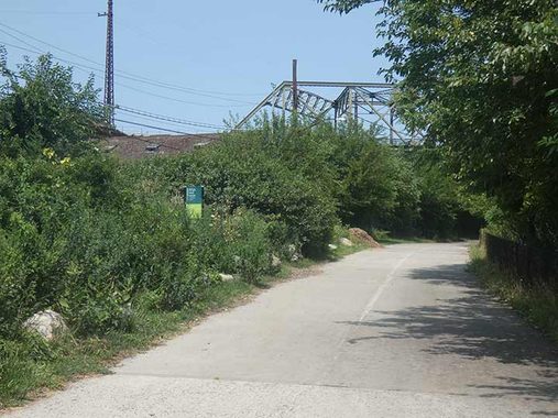
In fact, Concrete Plant Park is so green that views of the ruins of the Westchester Avenue train station are no longer visible (as they had been all year when I first visited the park). Today, such views are available in the cold months only.


“The Bronx River is an integral part of the evolution of this site, as it was both the catalyst for industrial development and later appeals for parkland. Concrete Plant Park, which runs along the western edge of the Bronx River between Bruckner Boulevard and Westchester Avenue, was formerly used for concrete production from the 1940s to 1987.
|
In 1987, the plant was shut down by the City, allegedly due to corruption charges, and it was subsequently abandoned for several years. In 1999, community groups advocated for the property to be turned into parkland and access be restored to the Bronx River waterfront. NYC Parks acquired the land in 2000 and, in close partnership the Bronx River Alliance, began the revitalization of this formerly abandoned site by re-establishing salt marshes on the riverbank once strewn with trash and tires. Concrete Plant Park was formally opened to the public in the fall of 2009.
|
Extensive site remediation was necessary to transform this industrial site into a park–including removal of contaminated soil and reintroduction of salt marsh vegetation. The restoration was a part of a larger effort that began in the late 1990s to restore the Bronx River’s aquatic habitat and natural ecosystems. Today park visitors can find an abundance of flora and fauna including Belted Kingfisher, Blue Crab, American Snapping Turtle, and Smooth Cordgrass.”
|
The extant storage silos in Concrete Plant Park provide a powerful link to the site’s former use. They were built by the Transit Mix Concrete Corporation for producing batch-mix concrete, and left intact when the site was abandoned. The red silos have since become sculptural features commemorating both the industrial legacy of the Bronx and the community whose organizing led to the site’s metamorphosis into a park.” [NYC Parks]


The Westchester Avenue drawbridge, and its truss elevated span are seen from Concrete Plant Park. Remember, it took years of rehabilitation to get the river back into the relatively decent state it is in today.


Continuing south, the freshly repaired Greenway path passes ramps connecting Edgewater Road to both the Bruckner Expressway and Sheridan Boulevard. Pedestrian/bike ramps here take patrons up to the Bruckner Boulevard sidewalk or to continue beneath the expressway in a tunnel. Once past the Bruckner, the park changes names again, to Garrison Park.


The last thing I expected to see at the south end of the Greenway path at Edgewater Road and Garrison avenue was a railroad and grade crossing, but that’s what we have: it serves as a freight line servicing the Hunts Point Cooperative Market, a wholesale food complex taking up 60 acres in the east end of Hunts Point between Halleck Street and the mouth of the Bronx River where it meets the East River. The market was founded in 1962 and is the main distribution center for produce for most homes and businesses in New York City; the Fulton Fish Market moved here after the better part of two centuries at the South Street Seaport. Its local railroad, run by CSX Transportation, was constructed during that time and has connections to the Oak Point Yard and a single track connection to the passenger Amtrak line.
Railroad.net has a photo of a freight using the line.
And:
Hunt’s Point Station


Thus ended my Greenway walk, but there were a couple of things to do before heading home. I went west on Garrison, then turned right on Hunt’s point Avenue and there it was, the former French Renaissance Hunt’s Point rail station that once served the New York, New Haven and Hartford RR and later, the NY, Westchester and Boston. It was open as a station from 1909-1937; it has been put to a variety of uses since, including a topless joint.
The southernmost extant station of the NY, NH & H is the Hunts Point station, on Hunts Point Avenue near the Bruckner Expressway. Most of the station is intact, including many of its peculiar architectural traits. Liek Westchester Avenue (see above) it was designed by Cass Gilbert. 1920 photo courtesy Ephemeral New York
According to NYC subway and railroad historian Joe Brennan…
The New York, New Haven and Hartford made its entry to New York via the Harlem Line in 1849, but the secondary route known as the Harlem River Branch was opened in 1868 mainly to make freight connections by water with other railroads. Local passenger service was also run until 1931. The line was rebuilt in 1908-1910 to 6 tracks with complete grade separation, and all new stations. It was also electrified. Most of the branch became part of the Hell Gate Route opened in 1917, the main line from Penn Station to Boston, and so it still has intercity trains today run by Amtrak. The portion south of 142d Street is now open for freight only.
(Footnote: From 1876 to about 1906, two passenger trains a day on a Boston-Washington run were carried by lighter (a barge with rails) between the old Harlem River terminal and the Pennsylvania Railroad at Jersey City, without a New York station stop. That unusual operation was then replaced by an inland route over the Poughkeepsie Bridge, and the trains were finally included among those using the new Hell Gate route starting in 1917.)
The dormer windows are mainly haunted by pigeons these days, though one still has a window, and another still has a spire. The Hunt’s Point station seems destined to be a new stop on a Metro-North extension to the Bronx by 2030 or so, but a new station will be built from scratch for it near the #6 Hunt’s Point Avenue station.

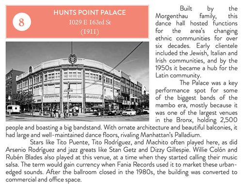
Bronx corners are often angles, and corner buildings were often constructed with what I call the sweeping “Bronx curve” as with this majestic building at Southern Boulevard and East 163rd, facing the source of Hunt’s Point Avenue. For the last couple itemsd on this page, I consulted Historic District Council’s “Six to Celebrate” Hunt’s Point booklet. All are available in digital form online.
Though the HDC has copy protections prohibiting copying and pasting text, there’s more than one way to skin a cat, like a screen grab:


Meanwhile, a couple of doors down on #961 Southern Boulevard is the former Spooner Theatre. According to Cinematreasures:
“The Spooner Theatre first opened in 1910 under local ownership. In April 1920 it was purchased by Loew’s Inc. who also operated the nearby Boulevard Theatre. Because the Boulevard Theatre was somewhat larger and also closer to busy Westchester Avenue, the Spooner Theatre was a subsequent-run house for its entire lifetime. In 1926 it was equipped with a Moller 3 manual 32 ranks organ. The Loew’s Spooner Theatre lasted into the late-1960’s or early-1970’s.
The building became a Kelly’s Furniture Store, then it was partly occupied by the inevitable Duane Reade Drug Store. By 2010, it was an El Mundo furniture store. In 2017 it became The Children’s Place clothing store.”
The theatre is now home to a children’s clothing store, mobile phone dealer, Burger King, and optometrist. Historic Districts Council:


The Hunt’s Point Avenue station on the Pelham Park IRT #6 line sits on an apparently recently remodeled pedestrian plaza at East 163rd Street and Bruckner Boulevard, but according to some reports, this will be where the new Metro-North station entrance will be constructed.


Though this station opened in January 1919, when you go down the steps you’re greeted with reproductions of a 1914 real estate brochure selling plots in Morris Park, which is a few miles away. “Decoration Day” is the old name of Memorial Day.
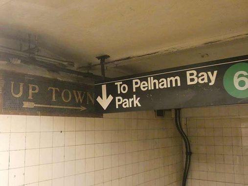
The station sports “Up Town” and “Down Town” directional mosaics, accompanied by modern-day signage.
Check out the ForgottenBook (HarperCollins, 2006), as well as Forgotten Queens (Arcadia, 2013). I also have a chapter in the anthology “New York Calling: From Blackout to Bloomberg” (Reaktion, 2007). As always, “comment…as you see fit.” I earn a small payment when you click on any ad on the site.
10/25/26