
Approaching Brooklyn College


Passing Glenwood Road (above left) and Utica Avenue (right) we passed some large tanks owned by Favorite Plastics, a manufacturer of polyethylene film.
Glenwood Road, and Albemarle, Beverl(e)y, Clarendon, Dorchester and Farragut, were once lettered, but several decades ago real estate developers though they’d sound better with sophisticated, vaguely British monikers. Avenues H through Z stuck with their letters, though Q became Quentin Road for Teddy Roosevelt’s son, who perished during World War I.
Utica is part of a different pattern altogether — here streets are named for New York State cities, progressing east from those closest to NYC: hence New York and Brooklyn Avenues first, ending with Buffalo Avenue.


Mixed messages in the graffiti along the fence on the railroad’s south side.


Approaching Albany Avenue the Bay Ridge Branch moves off the overhead trestle into an open trench, which will see it to its terminus at Upper NY Bay. Along the way is a siding connecting to another client, Glenwood Masons.
ABOVE RIGHT, FAR RIGHT: a new Target department store has been built near Flatbush and Nostrand Avenues, “The Junction.” Target funded improvements to the lengthy tunnel, which are hinted at in the non-flash photo at far right.


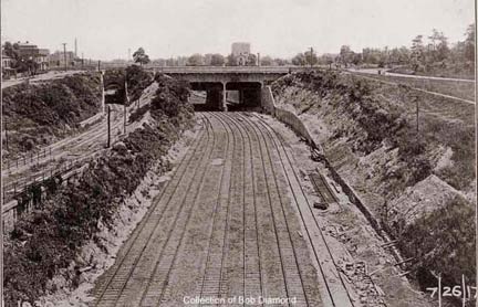
This was the former location of the Flatlands, later Vanderveer Park, station until 1924. On the map, the wide stripe at right is Flatbush Avenue while the thinner one is now Campus Road North and Amersfort Place.
Vanderveer Park was a development sponsored by Henry A. Meyer’s Germania Real Estate Company, which in 1893 purchased acreage from the Vanderveer Farm. At the time there was talk of a Flatbush annexation to Brooklyn (which happened in 1894) and Meyer set about covering newly-cut streets with ornate Victorian-era buildings. The name Vanderveer Park survives in the Vanderveer Park United Methodist Church at Glenwood Road near East 31st Street. And, there had been a Germania Place, connecting Campus Road and Flatbush Avenue north of Avenue H at Brooklyn College, but in 1959 it was changed to honor the nearby Brooklyn College Hillel building, named for the first century AD Jewish religious philosopher.


The Bay Ridge runs immediately south of Brooklyn College; we saw one of the NY & MB’s old signals in the weeds. Boylan Hall, whose spire is seen here, was opened in 1936; the school was established in 1930 in downtown Brooklyn.


The Brooklyn, Flatbush and Coney Island Railway (the Brighton Line) began service in 1878, originally running from the Prospect Park entrance at Flatbush and Ocean Avenues south to the Brighton Beach Hotel, built near the water’s edge. By 1897 it was connected with the Fulton Street El; the connection survives today as the Franklin Shuttle).
Here the Manhattan Beach Branch turned south, paralelling the BF & CI south into Coney Island. ABOVE RIGHT: looking east after the Bay Ridge was placed in an open cut, with the Brighton running above. LEFT: Before the grade crossing elimination was completed, with the Bay Ridge crossing over the Brighton. Bob Diamond collection


The only (surviving) pedestrian-only passage over the Bay Ridge can be found just west of the Brighton Line between Avenues H and I. RIGHT: here, rails are used as a retaining wall.


Ocean Parkway, designed by Calvert Vaux and Frederick Olmsted of Prospect and Central Park fame in the 1860s and built between 1874-1880, has a relatively aged overpass; here’s a look at the brick vaulting. Not sure though if this dates to 1880 or the grade cross elimination of the early 1900s.
ForgottenWebhost Paul Matus: The LIRR tunnel under Ocean Parkway probably dates to the lineís opening in (IIRC) 1877, though it may have been modified.
There was no grade crossing to be eliminated at O.P. The parks commissioners refused to let a rail line cross Ocean Parkway at grade. The Coney Island and Brooklyn (aka Slocum’s Line aka B68 bus) had to detour south on PROW to cross at the very bottom of Ocean Parkway, where it becomes Surf Avenue. When the Nassau Electric wanted to build the Church Avenue trolley (now B35) work was held up at Ocean Parkway while the line was built on either side of it. The Parks people watched like hawks to make sure the NERR built the promised tunnel and not try to establish an easement by building tracks on the surface under cover of darkness (that sort of thing was done in those days).
The almighty Robert Moses, on the other hand, broke apart both the bicycle path and the equestrian path when he narrowed Ocean Parkway to build the Belt c. 1940.


The old Prospect Park and Coney Island line, constructed as a surface railway beginning in 1875 by Andrew Culver. It was purchased by the Long Island Rail Road in 1892; Brooklyn Rapid Transit, the precursor to the BMT, acquired the route in 1899 and it was elevated from the old Fifth Avenue El to Coney Island in 1919-1920, with surface tracks being used by trolleys until 1956 and then by the old South Brooklyn Railway freight line until 1978.
ABOVE LEFT: In 2009, the Bay Ridge Line travels under the F train; CENTER: the Culver on Gravesend Avenue meets the NY, BR & J at grade in the 1890s; ABOVE RIGHT: by the early 1900s, the NY, BR & J had been placed in an open cut and the Culver bridged over them on an overpass. Bob Diamond collection


A close look under the 19th Avenue overpass in Borough Park will reveal the only tangible remnant of the Parkville Junction, a pair of tracks that used to connect to the Culver on Gravesend (now McDonald) Avenue. This was a former busy interchange between the two surface routes.


We saw a couple of wrecked cars along the route. How they get here, who knows; where there’s a will there’s a way. New Yorkers often use open cut railroads as trashbins and dumps.


As far as I can tell, the New York, Bay Ridge and Jamaica did not have an interchange with the old Brooklyn, Bath and Coney Island RR that began operations along what is today’s New Utrecht Avenue in 1864; the line evolved into today’s elevated D and M lines here (since the letters change every decade or so, many still call it the West end).
Another great opportunity for a major transit interchange presents itself here, since the West End transfers to the Sea Beach (N train), and the Bay Ridge line can be converted into a transit route that would allow riders to easily reach the East New York interchange (A, J, L) from here. But it’s not in the cards.
We see another rusted signal just NW of the New Utrecht Avenue N line station.


The BMT Sea Beach (N train) parallels the Bay Ridge for most of the remaining trip. Juan Torres gave the blast he usually reserves for graffitists along the route. BELOW: a look at the Fort Hamilton Parkway station, with its unusually lengthy passage from the tracks to the street.


At the 8th Avenue N train station (my home station for several years), the Bay Ridge branch crosses under.
There is an unused platform crossover and entrance on the 7th Avenue end.


At 5th Avenue, the Gowanus Expressway passes over, creating an effect of three levels. Just past 5th, we saw the N train emerge from the 4th Avenue tunnel and whiz by, just feet away.

The grade elimination program had already been completed by the time the BMT 4th Avenue line (the R train) was being constructed in 1915, so engineers had to actually bridge the subway across the open cut but under 4th Avenue at the same time. Above: view looking west, and at left, a view looking east in 1917. Note how many tracks have been removed during the eighty years in between. Bob Diamond collection


Vinny stands west of the Third Avenue crossing in 2009; at right is a 1917 view. Things have changed considerably, as the 5th Avenue el has vanished (torn down in 1940 after a brief interlude as the support structure for the Gowanus Expressway) and the Expressway’s connection to the Belt Parkway was completed in the 1940s.
LEFT: postcard view of the el on 3rd Avenue crossing Shore Road Drive. The drive is just west of the tracks.
The NY, BR and J maintained a passenger station at 3rd Avenue very briefly between 1877 and 1880.


After one last switch was thrown it was time to pull into the tour finale at the 65th Street Yards adjoining the Brooklyn Army Terminal. Designed by Cass Gilbert, the terminal was completed in 1919 and for decades served as the country’s largest military supply base and was an embarkation point for US troops bound overseas, who traveled by train along the Bay Ridge branch here. In 1958, Elvis Presley was among the draftees who arrived here by train.
The Terminal functions today as a secure (not open to the public) industrial warehouse and commercial complex, with over 70 businesses and 2500 employees occupying the space, working with biotechnology, finance, light industry, textiles and apparel, and more.
![]() A new barge transfer/carfloat was constructed to connect to the Bay Ridge line at the 65th Street terminal in the 1980s. It has never seen any service at all, but it is still checked daily to see that it works.
A new barge transfer/carfloat was constructed to connect to the Bay Ridge line at the 65th Street terminal in the 1980s. It has never seen any service at all, but it is still checked daily to see that it works.
For years there has been a proposed plan to build a cross harbor tunnel that would connect the Bay Ridge branch to New Jersey, mitigating the need for carfloats. The plan is controversial, since residents in Maspeth, Queens say it would overwhelm the area with truck traffic.


Engine 151 could not be taken to the end of the tracks at the carfloat. The ties have deteriorated to the point that they probably cannot sustain the engine, which weighs approximately 125 tons.


The waterfront appears to be a good candidate for a waterside walkway and recreation area, with the Manhattan and Jersey City skylines visible. At right is the new Beacon residential complex, a restored Art Deco era former hospital.


We parted company with Joel at this walkway on 61st Street and 11th Avenue, in front of the former Comet Laundry. Thank you to Joel Torres and the New York and Atlantic Railway for making this day necessary, as Yogi would say.
More on the Bay Ridge Branch:
Bob Andersen’s LIRR History
Tom Scanniello’s OLDNYC explores the route, which was once considered for a Cross Brooklyn Expressway.
Photographed March 21, 2009; page completed March 29
©2009