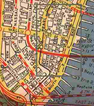
This 1946 Hagstrom of the Wall Street area (boxed in gray) of Manhattan shows a large number of streets that have disappeared over the decades, many of which made it into the 1970s.
The Sixties and Seventies were eras in which dozens of streets were eliminated to make way for developments like the World Trade Center.
Below we’ll show you where the streets were and what’s where they were (are?) now!
![]() Location: between Water and South Streets north of Coenties Alley
Location: between Water and South Streets north of Coenties Alley
What’s there now? 55 Water Street, built in 1972
Location: between Water and South Streets north of Old Slip
What’s there now? survives as a public walkway between 77 Water Street (1970) and 95 Wall Street
Location: between Water and South Streets just south of Wall Street
What’s there now? 95 and 111 Wall Street
Location: between Water and South Streets north of Pine Street
What’s there now? Wall Street Plaza (1973); Continental Center (1983)
Location: between Bridge and Pearl Streets west of Whitehall Street
What’s there now? 1940s city directories list Chesebrough Court, but today no trace exists.
Location: between William Street and Broadway, just south of Wall Street
What’s there now? Exchange Place. Laid out by the Dutch, it was originally called Tuyn (Garden) Street, later as Church Street. It was named for the Merchants Exchange, first built in 1825; through a series of absorptions, it’s now part of Citicorp.
Location: between the East and Hudson Rivers, north of John Street
What’s there now? Fulton Street. West of Broadway, it was named Partition Street; east of Broadway, Fulton was called Fair Street. Both were renamed for the pioneer and popularizer of the steamship, Robert Fulton.
Before 1971, Fulton was the southernmost street in Manhattan to go river to river. The construction of the World Trade Center cut it back to Church Street. Today, the title is held by Houston Street.
TRIBECA
In the 1946 map shown above, every street except Chambers, Warren and Murray west of Greenwich Street has been eliminated through one development or another, most notably Independence Plaza (1975).
In this area, two tiny alleys in the former Washington Market area were sacrificed (see below).
In the mid 18th Century there were also several streets that haven’t been there for quite awhile.
Formerly a Syrian enclave, this area was known for its active piers and for the old Washington Market.
maps © Hagstrom Inc
Location: between Warren and Chambers Street just west of Greenwich Street
What’s there now? Independence School
Location: between Jay and Duane Streets east of West Street
What’s there now? Borough Of Manhattan Community College (begun 1976, completed 1980)
Location: Dey and Greenwich Sts. north to Murray Street
What’s there now? The former World Trade Center site south of Vesey St. (1970); renamed West Broadway (about 1845)
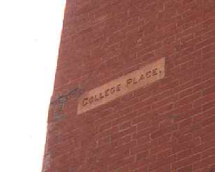
 “College Place” sign on West Broadway and Warren Street.
Location: old name of College Place below Murray Street; extended north to Canal Street
What’s there now? Renamed West Broadway about 1845
Location: Canal Street at about Chapel Street north to Amity (West 3rd) Street
What’s there now? Renamed and widened as West Broadway (about 1845)
Notable: West Broadway itself between Houston Street and Washington Square Park was renamed LaGuardia Place after Fiorello LaGuardia’s death in 1947. The portion south of Vesey Street was obliterated by the World Trade Center construction in the late 1960s.
Location: College Place west to West Street, south of Murray Street
What’s there now? The former World Trade Center site (1970). Robinson Street was renamed Park Place in the late 1800s, then eliminated by construction of the WTC.
Location: 474 Washington Street west to West Street south of Canal Street
What’s there now? Subsequently absorbed by Canal Street as it was widened. However, another tiny street named for a New Jersey town, Weehawken Street, survives ten blocks north of here.
CIVIC CENTER EAST
 More than any area of lower Manhattan, the Lower East Side and the area between the Brooklyn and Manhattan Bridges has been almost completely changed since the early part of the 20th Century as housing projects have replaced the ancient tenements and confusing maze of streets that used to dominate the region. The infamous Five Points lurked at the western edge of this area.
The levelling of Scollay Square in Boston to make rom for the new Government Center in the 1960s is comparable to this area for general elimination of a neighborhood.
In addition, many streets that formerly went through this area have been drastically cut back: for example, Cherry Street, which used to start at Pearl and Dover Streets at an intersection called Franklin Square (at a point where the Third Avenue El passed beneath the Brooklyn Bridge), now begins at Catherine Street. Water Street began at Whitehall and proceeded uninterrupted to Jackson Street; today its lower part has become a main thoroughfare, while its northern part has been chopped to bits.
Location: eastern extension of Chambers Street, from Park Row and Duane Street east to James Street and Cherry Street
What’s there now? Police Headquarters; Governor Al Smith Houses (1952). Today, Avenue of the Finest replaces it, although in a southeast direction to South Street.
Location: southern extension of The Bowery, from Chatham Square south to Pearl Street
What’s there now? Renamed St. James Place in 1947 in honor of Governor Al Smith, a parishioner at St. James Church on Oliver Street.
Notable: Shearith Israel, the oldest cemetery in Manhattan, is on this street.
Location: Park Row between Nassau Street and the Bowery
What’s there now? Renamed Park Row in the late 1800s
Location: from Gold Street east to Pearl Street at Peck Slip
What’s there now? Southbridge Towers (1969)
Notable: Ferry Street was probably named for the nearby Fulton Ferry which connected the Fulton Streets in Manhattan and Brooklyn from the late 1700s to the 1920s.
Location: from Ferry Street north to Frankfort Street
What’s there now? Southbridge Towers
Location: John Street northeast to Hague Street
What’s there now? Southbridge Towers, Brooklyn Bridge vehicular approaches, New York Telephone Building. A short stretch of Cliff Street survives between John and Fulton Streets.
Location: Tiny alley between Cliff Street and Pearl Street
What’s there now? Bell Atlantic Telephone Building.
Notable: name reflected Manhattan’s early Netherlands legacy as do Dutch Street and St. Nicholas Avenue.
Location: The northern end of William Street extended well north of where it does today, all the way to Pearl Street near Park Row; today only goes as far north as Beekman.
What’s there now? NY Infirmary Beekman Downtown Hospital (1971); Pace University (1970); Brooklyn Bridge vehicular approaches; Police Headquarters. A small piece of William Street can be seen at Frankfort Street east of Park Row.
Location: Frankfort and Gold Streets under the Brooklyn Bridge northeast to New Chambers Street
What’s there now? A small piece survives under the Brooklyn Bridge approach, from Frankfort northeast to Avenue of The Finest at Madison Street. The rest of Rose Street was replaced by Murray Bergtraum High School (1976).
Notable: for a brief time in 1844, Rose Street was home to the mayor’s official residence.
Forgotten Fan Peter Sefton has an account of the old days on Rose Street:
Even in the 1920s, Rose Street was called dingy and gloomy, but it was once a street of mansions and with a lively past.
In 1834, there was a series of anti-Black and anti-abolitionist street disorders, partially in reaction to British endorsement of the abolitionist cause. one evening, after attacking a theatre where the manager was an Englishman, to a mob battered down the front door of the wealthy abolitionist Lewis Tappan’s Rose Street mansion. While ransacking the house, the rioters piled his furniture in the street and poured kerosene over it. But the story is told that, when someone tore a portrait of Washington off the wall and tried to use it for kindling, there was a roar of protest-“for God’s sake, don’t burn Washington!”
As a later 19th century writer noted “In an instance, the spirit of disorder was laid, and the portrait was handed carefully from man to man, til, at length, the populace carried it to a neighoring house for safety”, attended by an honor guard of rioters. It’s unknown what proportion of this was patriotic fervor and what was admiration for the greatest kicker of British butt in history.
This lull in the riot probably saved Tappan’s house from total destruction, because the “leatherheads” of the police force drove off the rioters, who still managed to bombard them with bricks and to torch the furniture pile.
The Dover paperback Old New York in Early Photographs has a evocative shot of the corner of Rose & Duane Streets. Not many mansions around even in 1890.
Location: Frankfort Street near Cliff Street northeast to Pearl Street at New Chambers Street
What’s there now? Brooklyn Bridge vehicular approaches; Bell Atlantic Telephone Building
Location: Tiny alley, extended from New Bowery at Pearl street southeast to Cherry Street
What’s there now? Governor Al Smith Houses (1952)
Location: Another short alley, between Roosevelt and James Streets, crossing New Chambers
What’s there now? Governor Al Smith Houses
Location: Pearl Street at Park Row southeast to South Street
What’s there now? Chatham Green Houses (1961), Gov. Al Smith Houses.
Notable: Rosevelt, or Roosevelt, Street appears on maps in the mid-1800s, so it was not named for Teddy. “Roosevelt” is a prominent Dutch name in the NYC area throughout its history. A Roosevelt owned property in the area in the late colonial period.
Location: Between 84 Henry Street and Madison Street.
What’s there now? This was a southeastern extension of Forsyth Street along the Manhattan Bridge.
Location: Between 73 Catherine Street and the intersection of Monroe and Market Streets. The one-block street bent to the northeast.
When first laid out on maps of the late 1700s, Hamilton Street was called Cheapside, after the London thoroughfare; it was renamed about 1827.
What’s there now? Knickerbocker Village, built in 1934, which was the very first major housing project in NYC to be partially aided by public funds.
Location: from Chatham Street (Park Row) and Pearl Street west to Broadway
What’s there now? Magazine Street became part of Pearl Street in the mid-1800s. The section of Pearl Street between Lafayette Street and Broadway was demapped in 1963 to make way for what is now called the Jacob Javits Federal Office Building (26 Federal Plaza)


1 comment
[…] his “trial” sermon. He was an early Sabbath-school teacher, and once in the lecture-room in Rose Street, when he had eleven boys in his class, four of whom became clergymen – the late Rev. Dr. […]
Comments are closed.