I’ve always been proud of the fact that I know quite a bit about the artifacts of a New York City of long ago. After all, that’s why I got the idea to start a website about Forgotten NY in the first place. But occasionally, even I get stumped by something I spot while wandering around with my camera. Fortunately, a little research goes a long way and I can usually come up with an answer.
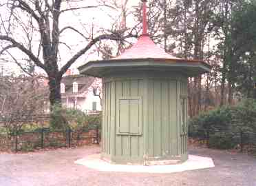
In Brooklyn’s beautiful Prospect Park on Flatbush Avenue, a little north of the intersection with Ocean Avenue and Empire Boulevard, you can see this small green structure, which looks a lot like a ticket kiosk.
It’s not a kiosk. In fact, it’s two…two…two landmarks in one!
It’s an early version of a tollbooth! It collected fares on the old Flatbush Turnpike, which generally followed the route of today’s Flatbush Avenue, from the colonial era until NYC consolidation in 1898, when Brooklyn, Queens and Staten Island joined Manhattan and the Bronx as the five boroughs we know and love today.
The Flatbush Tollgate. Another historic structure, the Lefferts Homestead, can be seen in the background. It was built in 1777 by Lt. Peter Lefferts to replace his original house, burned by the British in the war. It was originally at what is now 563 Flatbush Avenue, but was presented as a gift to Prospect Park by Lefferts’ descendants in 1918 and was moved here shortly after.
photography: Doug Diamond
The old tollgate also reminds us of a time when more than one town made up Kings County. Since the late 19th Century, Kings County and Brooklyn have been coterminous, but this hasn’t always been the case.

On this 1898 Brooklyn Eagle map, the zigzagged purple line in the center marks the dividing line between the towns of Brooklyn and Flatbush. The tollgate was located at the border, at Flatbush Avenue and Malbone Street (gray square), which had its name changed after a horrible subway accident in 1918. Travelers would be obligated to pay a toll for maintenance and upkeep of the Flatbush Pike upon leaving and entering Brooklyn. A number of tollbooths were scattered along the pike for collection
After consolidation, the practice of collecting tolls was dropped. Most of the tollbooths were demolished. The one pictured above became a backyard garden structure when it was removed by an area resident and placed on his property. A subsequent homeowner in the 1950’s realized what he had in the backyard and contacted the City’s Parks Dept. It was restored (it is mostly wood) and placed in its current location which is not far from its original position which was at the intersection of Flatbush & Lefferts Avenues.
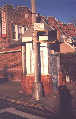
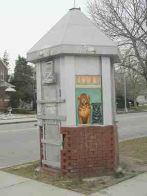
Similar structures exist in Sheepshead Bay like this one at Oriental Boulevard and Westend Avenue; the other one can be found at Shore Boulevard near the Ocean Avenue pedestrian bridge.
These weren’t tollbooths though. These structures are reminders that this used to be a private neighborhood (like Sea Gate to the west) called Manhattan Beach Estates. It was opened in 1906. Police guards posted at these gatehouses allowed only residents and expected guests to enter the area.
The shadowy figure in the right foreground is your webmaster.
Why is There a “Gravestone” on Ocean Parkway?
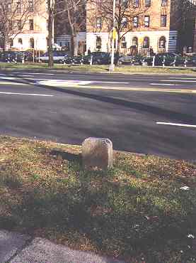
When I lived in Bay Ridge, I would frequently bicycle down Ocean Parkway from Church Avenue to Coney Island. It boasts a world-class bike path and it’s flat as a pancake…you can make good time even if you’re going against the wind.
Just past Avenue P, I’d notice this little stone with a beveled edge up against the roadway. I must have gone past it hundreds of times in the 70s, 80s and 90s.
Looks like a small gravestone, doesn’t it?
Yet, I never thought it was a gravestone, unless it was an original plot that Ocean Parkway went through when it was first built. I had something else in mind. And, upon further investigation, my suspicions were confirmed.
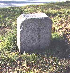
It is a mile marker dating back to the early days of Ocean Parkway. This one, marked 3M, marks the third mile from Ocean Parkway’s northern terminus at Prospect Park.
When renowned city planners Frederick Olmstead and Calvert Vaux built Ocean Parkway between 1874 and 1876, they envisioned a six-mile long extension of their earlier creation, Prospect Park, which some say is even better than their masterpiece, Central Park. When first laid out, Ocean Parkway was a direct route for pedestrians and mounted traffic, as well as buggies and wagons, to get to the Coney Island shore from Prospect Park. Even the bicycle wasn’t yet invented when the parkway first appeared.
These days, of course, Ocean Parkway is a pedal to the metal speedway, with synchronized stoplights. Occasionally you can hit the jackpot and never hit a red light while driving from the Belt Parkway to Prospect Park.
Ocean Parkway milestones were placed at half-mile marks along the route. Only this one, by some stroke of fate, remains.
Milestones were a common method of marking private routes beginning in the colonial era and lasting until the start of the 20th Century. Relatively few NYC thoroughfares boasted them, although the old Bloomingdale Road (now Broadway) in upper Manhattan had them, as well as Jackson Avenue (now Northern Boulevard) in Queens.
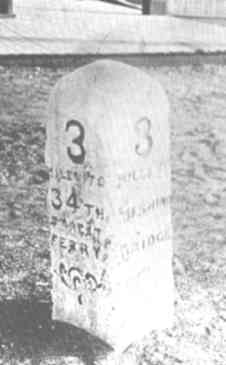
This milestone was one of a number posted along Jackson Avenue in northwest Queens.
Like the Flatbush Turnpike, Jackson Ave. (now Northern Boulevard) was originally a toll road, built by John Jackson, supervisor of the Hunter’s Point, Newtown and Flushing Turnpike Company in 1859 with tollgates and fencing along its route.
Jackson also set up stone mileposts along the route which showed the mileage to the 34th Street Ferry terminal as well as the mileage to Flushing Bridge (which spanned the Flushing River).
This post was placed at Jackson Avenue and what is now 62nd Street.
One of these mileposts survived in place until 1987! It has been preserved at the Langston Hughes Queens Library branch in Corona.
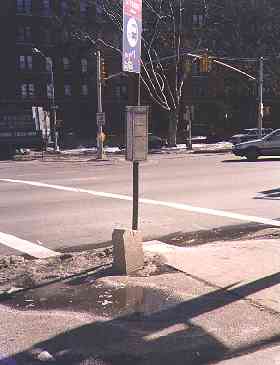
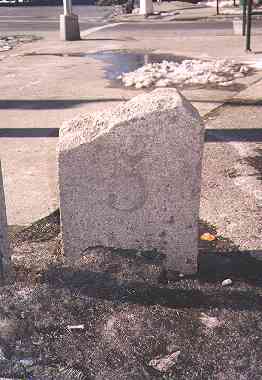
The Ocean Parkway 5-mile marker, at the corner of Neptune Avenue, survived until a sidewalk repair job claimed it in 2010. These were never landmarked, so they have gradually disappeared over the years, unsung anywhere but here in FNY.
And also at Sheepshead Bites.
Ex-Milestones Ocean Parkway map
Further Down the Parkway
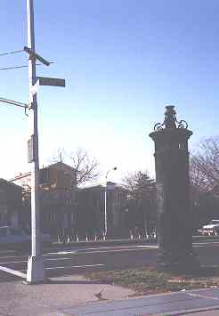
Is it the last Mohican of an ancient lamppost design? An old fire engine call box lamp? A monument perhaps?
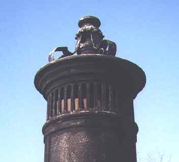
It’s big, it’s ornate, it’s rusting, and I hadn’t a clue what it might be. It’s on the northeast corner of Ocean Parkway and Avenue U. It looks like a decorative torch that may have been one of many placed along Ocean Parkway, but wear, tear and pollution have taken their toll.
Well, apparently the mystery is solved. Forgotten Fan Joseph Ditta of Gravesend, Brooklyn reports…
This is from Oscar Israelowitz’s “Flatbush Guide” (Brooklyn, NY: Israelowitz Publishing, 1990; page 39):
“The unique cast-iron tower located on the northeast corner of Ocean Parkway and Avenue U is the air vent for the sewage pumping station beneath that intersection.”
The question is, is the sewage pumping station still there and do the local denizens know about it?
ForgottenFan Rob Firriolo:
Yes, it is still there, and indeed they know about it, at least those who lived there back in the late-1980s did. At that time, I was the resident field inspector with NYCDEP and had daily oversight over the extensive reconstruction project of that pump station. (I worked out of the DEP field office trailer located on-site.) The project took a couple of years, during which the entire station area was dug-up, along with sections of Avenue U heading toward McDonald Avenue.
The dry well (where the control room and pumps are located) is directly under the pedestrian island and is accessed via a Bilco door (one of those silver plates on the ground).
The wet well (where the sewage collects for pumping) extends out beneath Avenue U, and the sewage is pumped up into a force main that extends several blocks down Avenue U (to around E. 2nd street–I forget exactly how far it went when we slip-lined the old cast iron pipe with a plastic pipe). From there the sewage flows by gravity (downhill) toward the large, aboveground pump station on Ave. V between 86th and W. 11th Sts.
The vent tower was not the only structure at that location. Prior to the reconstruction, there was a small brick and stone structure that served as the entrance to the station. It looked like a small shed, with a door and a peaked roof, and, as I recall, a stone cornice above the door. Beyond the door was nothing but a stairway that led down into the old station. The structure was demolished and replaced with the Bilco door. I recall discussion about preservation of the structure prior to its demolition, but it was ultimately decided there was nothing that could be done with it. If you locate historic photos of the corner, you will see the entrance structure.
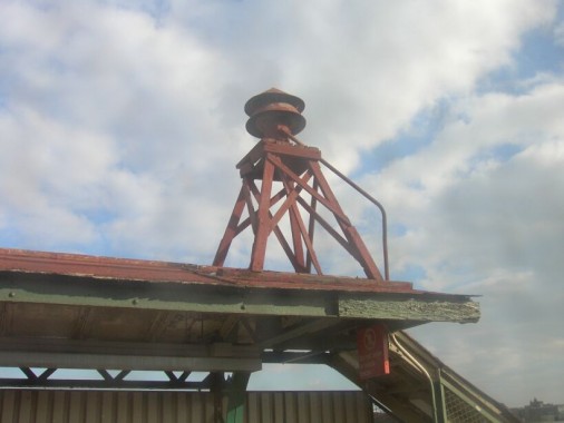
Every fifth lamppost used to have them.
You heard them go off at noon every day.
They were placed at the height of the Cold War (1945-1990), when there was a communist under every bed and that kid with the beard next door was a Castro-lovin’ red diaper baby. They were air raid sirens; the Cold war legacy can still be seen on myriad apartment buildings around town that still sport Fallout Shelter signs.
In reality, an H-bomb would likely flatten the entire northeast, rendering duck and cover exercises and fallout shelters superfluous. You’d be dead anyway.
Is that era returning post 9-11? Freedom is always under attack from people who don’t believe it’s good for us.
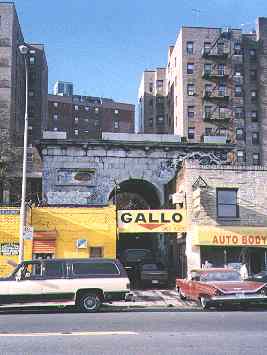
What’s this…a relic of ancient Rome magically beamed over to modern-day Broadway and West 215th Street in Inwood? What is a (presumably) once-grand archway doing in this gritty setting?
Well…
Let The New York Times publication The Curious New Yorker take it from here.
In 1851, the Seaman family bought a 25-acre hillside parcel between 214th and 217th Streets, which included a number of marble quarries along the old Kings Bridge Road. Marble from these quarries was used to build a mansion, and at the base of the hill, a monumental entry arch 35 feet tall, 40 feet wide, and 20 feet deep…
The estate later passed to the Drake family, then to a contractor who used the arch as a business office, according to Christopher Gray, an urban historian…
Since about 1960, the arch’s central vault has led directly into the garage of Jack Gallo’s auto body shop. Mr. Gallo says the inside of the arch, now bricked over, was once inhabited by the gatekeeper for the estate, and in later years was used by a social club. Though obscured these days by a cacophony of signs and shops, it remains a quietly astonishing sight.
Note the 1959 Buick on the right. 2004: Gallo Auto Body has moved out.
Sources:
The Curious New Yorker, New York Times Books, 1999
Woodside, A Historical Perspective, 1652-1994, Catherine Gregory, Woodside On The Move 1994
AIA Guide To New York City, White/Willensky, Harcourt Brace Jovanovich, 1988
Special thanks to Doug Diamond, Paul Lukas and Joseph Ditta for assisting with this page
1/20/2000; revised 2004, 2012

11 comments
Very happy to see a reference to the fantastic Ocean Parkway bike path, one of the most pleasant (and, as you say, smoothest) urban bike routes to be found anywhere. Best of all, it is also the city’s (and who knows, the country’s?) oldest bike path, the granddaddy of them all, opened in 1894, nearly 120 years ago. There are some great vintage photos to be found in the archives of primly dressed ladies and gents pedalling their velocipedes and penny farthings along this route way back when. The Ocean Parkway Malls were designed by Olmsted and Vaux and the bike path shares their shady beauty. It’s a terrific ride from Prospect Park to Coney Island via this route, especially on a Saturday when the neighborhoods the path passes are dead quiet.
The days of my youth were spent taking long walks radiating from my apartment on Ave U and Ocean Ave. One occassion, I walked to visit my sister who had just moved to Mill Basin. There were no roads in Mill Basin for years, and I remember walking on the dirt streets. On many occassions though, I walked down to Ocean Parkway. Reading these articles sent me right back to my youth. On some occassions we would ride the bike paths, and I vividly remember that the other side of the street held a bridle path. Is that still there?? I remember the small brick building that hosed a stairecase leading under Ocean Parkway and our awe when we saw the door open one day and a staircase leading down. The mile markers on Ocean Parkway were familiar to me in those days of youth and when I saw the photos posted a smile crept on to my face. My mother loved to explore the City and I guess that’s how my passion was formed. One day on one of our walks we walked to Washington Cemetery. I remember her pointing out the grave of a silent movie actress but I don’t remember who it was (actually my mom is 96 and she probably remembers!). What I do remember though is a grave with inscribed “Killed by a bear on The Ocean Parkwy”. It was a visual that stirred the imagination of a nine year old boy that stayed with him into his sixties.
TO MARK BENDER, FOR YEARS WHEN VISITING MY GRANDPARENTS GRAVES I HAD TO GO AND LOOK AT THE GRAVE OF THAT LITTLE BOY KILLED ON THE OCEAN PARKWAY. DO YOU BY ANY CHANCE KNOW THE NAME OF THAT LITTLE BOY SO THAT WE CAN DO FURTHER RESEARCH?
Nice stuff – I love this! Not having lived in Brooklyn for over 30 years I still consider it my home. Re Ocean Parkway: When I was very young my family lived in Borough Park. We had quite a large extended family that lived within a 10 block or so radius. On beautiful spring days we would gather with the baby carriages etc. and walk over to Ocean Parkway (we were on 15th and 42nd) and proceed to caravan up the Parkway to Prospect Park. I was doing this as young as 4 or 5 – no carriage for me – and I walked with the grandmothers, mothers, aunts, cousins, etc. and the babies in their carriages. What pleasant memories that beautiful boulevard provides me!
I just found this site by accident, looking for my old stomping grounds where I grew up. Born in Manhattan, raised in Bklyn. till 4th grade and off with the military, as dad was in the Army, we, my family and I will always be New Yorker’s. I was just approached by a woman who asked Q: if I was from NY and A: I said yes, how do you know, A: your accent. very slight of course. I went to Manhattan beach, there was a street at the end called Quentin St. owned by the military, and military families lived there. It has since become a parking lot for the “Kings…. Community College.” I remember their gym was like huge white tents back in the day. The candy store by the entrance of the college is still there, JJ Reynolds Jr. High (now an Arts school, Abraham Lincoln HS… Thank you for the old pics, history and the new.
Great reading and seeing these pics, I grew up on Bragg St between X&Y my parents bought our new home in ‘58 and lived there until ‘77 what great memories I have of that neighborhood. Sad that it changed for the worse, everytime I go back it looks worse, so sad. Inspite of all the changes, Brooklyn will always be home to me…..
Was there ever a subway that went from Avenue U up Flatbush Ave to Prospect Park? I have some old transit maps that show there was such a subway route.
Never
I love old history about Brooklyn. I’m still
Trying to find old photos of my house which was built in 1907, a typical craftsman with open porch, at the intersection of Dahill Rd and Ave O. I’m on the West side of the street facing directly up Ave O. The house most likely had a clear view to Ocean Parkway because I believe I am in the oldest existing house of the area. Back in the day I believe Dahill Road was called West St. I would appreciate any help you can give. Thank you.
Kevin,
The booths in Manhattan Beach were erected in 1946 by the NYPD in response to a crime wave in the neighborhood. See https://argyleheights.blogspot.com/2016/07/manhattan-beach-police-booths-sam.html or a
shorter version at https://joeenright.com/2020/04/16/manhattan-beach-memories-by-joe-enright/ It’s a miracle they’re still standing!
A car crashed into the ornate old-school vent at Ave U and Ocean Parkway last night and completely knocked it down. I haven’t checked to see if it was removed but my guess is, even if it hasn’t been yet, it won’t be put back up.