“DOWNTOWN” BROOKLYN, FULTON FERRY, ‘DUMBO’
These three areas, on the present-day map pf Brooklyn, encompass all the territory north and east of Old Fulton Street/Cadman Plaza West, to the Brooklyn Navy Yard on the east and Fulton Mall on the south. This part of Brooklyn has seen the most change since the 1930s as urban renewal, hotels, a new business district, and housing projects have swept away tenements, shanties, and the small businesses that had sprung up there since the Fulton Ferry began plying the East River in the 1810s. Here and there, though, hints of the past still hang on: a clutch of brownstones at Concord and Duffield Streets, and more brownstones and the ghost of a business center on Hudson Avenue in Vinegar Hill. Much of this area has become dark and forbidding, especially around the projects, but there are hints of a revival as DUMBO (“Down Under the Manhattan Bridge Overpass”) is beginning to repopulate and plans are drawn up for a grand riverside park.
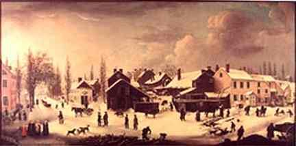
This 1853 painting, Winter Scene in Brooklyn, by Louisa Ann Coleman, depicts Brooklyn, just east of Fulton Ferry, as it was in the mid-1820s.
Front Street, then a fashionable street lined with upper-class residences, is in the foreground. We are looking south with Main Street on the left and Fulton Street on the right. Until the mid-1800s Front Street was indeed the waterfront, before landfill extended Brooklyn into the East River a couple of blocks.
Picture from the Museum of the City of New York.
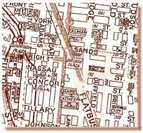
This map of the area is a circa-1935 Geographia, and shows the street layout just before many of the streets were demapped and mass demolitions for housing projects began.
The Brooklyn Bridge, which still boasted trolley and elevated train service, is at left (Sands Street/Gunnison Plaza was a major transfer/terminal) while the Manhattan Bridge angles diagonally from the center. The new IND runs under Jay Street (center) and High Street. With the Fulton St and Myrtle Avenue Els, trolleys, buses, and three separate subway companies (the IND, BMT and IRT), the late 1930s were the golden age and heyday of Brooklyn mass transit.
At far left of the map, what would become Cadman Plaza is represented on the map. West Parkway was proposed and was never built, but Fulton Street would be widened and become Cadman Plaza West.
Many small streets were truncated or destroyed by the Brooklyn Bridge and, much later, the BQE:
Location: From Fulton Street near Cranberry Street east to Navy Street.
It’s probable that High Street, which shows up on 1820s maps, marked an area of high ground; whatever hill was there has since been leveled.
The present corner of Cadman Plaza East and Red Cross Place is actually the OLD corner of Washington and High Streets.
Red Cross Place, a cut-off piece of High Street.
What’s there now? High Street used to run for eight blocks, but has been repeatedly truncated, first by the new Manhattan Bridge approach in 1909, and then by the 1930s Farragut Housing project and then by the new Cadman Plaza in the late 1950s. Today, two pieces exist: a short block between Pearl and Jay Streets in the Manhattan Bridge shadow, and the renamed Red Cross Place between Cadman Plaza East (old Washington Street) and Adams Street, itself rebuilt as a multi-lane Brooklyn Bridge approach.
The High Street IND stop on the IND 8th Avenue Line (A) is actually on Cadman Plaza East and is a reminder that High Street used to extend this far, but no more.
Location: Poplar Street west of Hicks Street NE to Fulton Street
What’s there now? Most of McKenny Street was swallowed by the new Brooklyn-Queens Expressway when it was built between 1946 and 1953. However, a small piece of it is still detectable at Doughty Street near Old Fulton Street.
1827 Hooker’s New Pocket Plan showing street configuration before construction of the Brooklyn Bridge
Location: From Main Street, just north of Fulton, northwest, parallel to Fulton, to Front and Dock Streets
What’s there now? The Brooklyn Bridge. James Street was among a number of small streets that were obliterated when the Brooklyn Bridge construction started in 1870. The Bridge opened in 1883.
Location: from Fulton Street opposite Duckbees Alley northeast to James Street
What’s there now? Destroyed by Brooklyn Bridge construction in the 1870s
Location: Garrison Street was a one block alley extending from York Street north to Front Street; Mercein Street was an even smaller alley that went from Garrison west to James Street (see map above)
Andrew Mercein, the son of immigrants from Switzerland, was a political leader in Brooklyn Village in the 1810s and one of the founders of the Brooklyn Institute. John Garrison, originally a butcher by trade, later a judge, was the first president of Brooklyn Village.
What’s there now? Though both these tiny streets survived the construction of the Brooklyn Bridge, they couldn’t make it through the onslaught of the Brooklyn-Queens Expressway, and didn’t make it far into the 1950s.
Location: Plymouth Street between Jay St. and Bridge Street south to Water Street
What’s there now? Commercial buildings
Location: Originally, Stewarts Alley ran from Prospect Street just east of Main Street north to Front Street (cf. map above). By 1916, directories were listing it as Flint Street.
What’s there now? Spared by Brooklyn Bridge and BQE construction, but warehousing and parking lots are now where Stewarts Alley/Flint Street used to run.
Just as well, since Brooklyn has two Stewart Avenues and a Stuart Street today.
Location: from High Street near the Brooklyn Bridge entrance plaza south to Fulton Street at Tillary Street
What’s there now? Today, Liberty Street is covered by Parkes Cadman Plaza.
Location: Named for one of the first two doctors of Brooklyn Village in the early 19th Century, Dr. John Joel Barbarin, this street stretched between the waterfront on the north and Myrtle Avenue on the south, midway between Jay and Bridge Streets.
The other doctor, John Duffield, also had a street named for him that still survives.
What’s there now? Barbarin Street was gone from Brooklyn maps by the end of the 1800s. No trace of it exists today as its space has been filled by warehouses and commercial buildings.
Poly Tech, the St. James Cathedral, and the BQE and Manhattan Bridge approaches also cover Barbarin Street’s old path.
Location: Stanton Street ran parallel to Barbarin Street, from the waterfront south to near Fulton between Bridge and Gold Streets, in the early 1800s.
What’s there now? By the middle of the 19th Century, the northern part of Stanton Street above Sands Street had been renamed Charles Street. The southern part south of Nassau Street survives today as Duffield Street.
Location: Charles Street was the northern part of Stanton Street, laid out in the early 1800s. By the late 1930s Charles Street had been truncated to a short stretch between Sands Street on the south and York Street on the north, east of Bridge Street (see map above)
What’s there now? The massive housing project, the Farragut Houses, now occupies Charles Street’s old path.
Location: Talman Street was a narrow lane which ran between Jay Street east to Charles Street, just north of Prospect Street (see above map)
As it turns out, we have a visual record of what Talman Street looked like, thanks to Berenice Abbott’s photos from Changing New York in the late 1930s. These flimsy-looking dwellings were typical of the neighborhood then. Very few of these type homes remain in this neighborhood today.
What’s there now? Today the BQE and Farragut Houses occupy all of Talman Street’s old path. Except…. This small piece of Talman Street, on Bridge Street, has been converted to a parking lot entrance.
Location: Harts Alley, later named Mack Place, was a short alley between Bridge and Gold Streets just north of Nassau Street.
What’s there now? Sacrificed in the 1940s for construction of the Brooklyn-Queens Expressway.
Location: Gothic Alley was a tiny thoroughfare that went between Adams and Pearl Streets just south of Nassau Street. Its western end was in the shadow of the elevated train that went along Adams at the time.
What’s there now? New York City Technical College. Pearl and Nassau streets no longer border here anymore either.
Location: Strangely-named Nutria Alley also ran between Adams and Pearl Streets just south of Concord Street.
A nutria is a fur-bearing, beaverlike critter native to South America, otherwise known as the coypu (right). Commerce in the early says of New York City relied heavily on the fur trade, and this street name may bear this out. Nutria (Myocastor coypus)
What’s there now? See above listing for Gothic Alley.
Location: The piquantly-named Way-Home was a short alley on Gold Street between Nassau and Concord Streets.
What’s there now? The Brooklyn-Queens Expressway, though Way-Home had gone away by the mid-1930s at least.
Location: Cornells Alley went from Gold Street east to the now-eliminated Green Lane south of York Street.
What’s there now? The Farragut Houses
Location: Force’s Place, Mumby’s Alley, Smith’s Alley and Snell’s Alley were a network of tiny alleys between Nassau and High Streets.
What’s there now? Their site is currently occupied by the Farragut Houses.
Location: 225 Fulton Street east to Liberty Street
What’s there now? Buried under S. Parkes Cadman Plaza
VINEGAR HILL is the only neighborhood in northwest Brooklyn that in any way resembles the way it looked in the late 1800s and early 1900s. Some of its brownstones and ‘cobblestoned’ (actually Belgian-blocked) streets survive, though Vinegar Hill is now in the shadow of a massive Con Edison plant that is as carefully protected and guarded as the gold in Fort Knox. Guards don’t allow photographs even from beyond the fence!
Two views of Hudson Avenue. The Con Ed smokestacks loom in the background of this 19th century throwback neighborhood.
Map of Vinegar Hill about 1935
Lost streets of Vinegar Hill and south:
Location: From the waterfront south to Fulton Street at Flatbush Avenue.
Today it is the ‘main drag’ of Vinegar Hill, but it formerly ran all the way south to Fulton Street and in fact, an elevated train (Brooklyn’s 5th Avenue El) ran along it between Myrtle Avenue and Flatbush. That part of Hudson Avenue has long disappeared along with the el.
There is still a 3-block stretch of Hudson Avenue in Vinegar Hill, and a short one-block stretch of it between Fulton Street and DeKalb Avenue at its southern limit. As well as…
A small piece of Hudson Avenue’s old right of way has been preserved as an entrance to parking lots of the University Towers at Willoughby Street.
What’s there now? Between York Street on the north and DeKalb Avenue on the south, Hudson Avenue was eaten away by the Farragut Houses, the Broklyn-Queens Expressway, the Raymond Ingersoll Houses, the University Towers, and Long Island University.
Location: Green Lane was between Front Street on the north and Prospect Street on the south, just east of Gold Street (see above map)
What’s there now? The Farragut Houses
Location: Prague Court, not to be confused with Sprague’s Alley (see above) was an alley on Front Street between Green Lane and Hudson Avenue.
What’s there now? Gone by the 1940s; local warehousing is there now
Location:U.S. (United States) Street is a dead-end on 17 Little Street north of Plymouth Street.
What’s there now? It’s still there. But only Con Edison employees can visit it. Con Ed took over the site in the mid-1960s and guards it with extreme prejudice.
Location: From York Street at Hudson Avenue and Navy Street south to Sands Street
What’s there now? Farragut Houses
Location: Ran diagonally between Sands Street and Hudson Avenue southeast to Navy Street
What’s there now? Farragut Houses
Location: As you might expect it ran from Nassau Street south to Concord Street, just west of Navy Street
What’s there now? Farragut Houses
Location: Dead end alley on Prince Street north of Tillary Street
What’s there now? BQE on-ramps
Location: 255 Jay Street east to Lawrence Street
What’s there now? Poly Tech University
Location: at the north end of Lawrence Street near Tillary Street.
What’s there now? a public park just south of the St. James Cathedral.
Entrance to Ft. Greene Park
FORT GREENE, roughly speaking, the area from about the Flatbush Avenue extension east to Washington Avenue and from the Brooklyn Navy Yard south to Atlantic Avenue, has also had its share of street eliminations, many due to routings of the Brooklyn- Queens Expressway and of housing projects over the years. Recent years have seen the construction of the massive MetroTech project have caused even more street closings.
Location:From Fulton Street at Montague Streeteast about ten miles to Jamaica Avenue at Lefferts Boulevard
What’s there now? Most of it is still there—in fact, all of it from Flatbush Avenue east. However, Myrtle Avenue has been made to suffer indignities over the years. First, a section west of Jay Street was removed for Parkes Cadman Plaza in the mid-50s.
Then, its el was taken down–it last ran in October 1969.
Finally, in the mid-80s a section of Myrtle Avenue was converted into a pedestrian mall in MetroTech Center.
“Myrtle Mall” in MetroTech Center
Location: Union Lane was a dead end alley on Myrtle Avenue between Adams and Pearl Streets.
What’s there now? Renaissance Plaza, constructed between Adams and Jay Streets in the 1980s and featuring the New York Marriott of Brooklyn, the first hotel constructed in Brooklyn in decades, occupies the area where Union Lane used to be.
Location: Bolivar Street stretched between Hudson Avenue north of Willoughby Street east to St. Edward Street at Fort Greene Park. Named, of course, for the George Washington of South America.
What’s there now? The University Towers housing project







1 comment
[…] [Map via Forgotten NY] […]
Comments are closed.