![]()
The beautiful Hell Gate Bridge, completed by Gustav Lindenthal in 1917, was the jewel in the crown of Alexander Cassatt’s Pennsylvania Railroad station in midtown, opened in 1910. The Hell Gate allowed the Pennsylvania RR a through route to Connecticut, Rhode Island and Boston.

View from the Hell Gate Bridge west toward Wards Island
The Hell Gate Bridge combines with the Triborough to give Astoria and Ditmars a bridge ‘double act’ achieved nowhere else in the city except for the Fulton Fish Market area and Brooklyn’s DUMBO, which can boast the Manhattan and Brooklyn Bridges.
That same year, 1917, the IRT was extended to Ditmars Boulevard (né Avenue) and attracted many Manhattanites to the nearby area. The Grand Central Parkway and the Triborough appeared in 1936, and after World War II Greek immigrants began the influx that continues to this day.
Ditmars extends from the East River on the west and north to the Grand Central Parkway on the south and Steinway Street on the east.
Of course, it originally had its own collection of streeet names.
Location: Between the East River and Old Bowery Bay Road (about where Hazen Street is now)
What’s there now? Ditmars Boulevard. It was gradually extended, in fits and starts, and now skirts LaGuardia Airport on its way to join Astoria Boulevard at about 111th Street. Sometime in the 30s there was a push to remoniker all main Queens routes as Boulevards, and Ditmars was among them. The boulevard occupies the space where 22nd Avenue might be expected.
Location: Barclay Street south of Ditmars Avenue east to Hallett Street.
What’s there now? 22nd Road.
Location: Barclay Street south of Ditmars Avenue east to Hallett Street.
What’s there now? 22nd Drive.
Location: Barclay Street south of Potter (23rd) Avenue east to Hallett Street.
What’s there now? 23rd Road.
Location: Barclay Street south of Potter (23rd) Avenue east to Hallett Street.
What’s there now? 23rd Terrace.
Location: Barclay Street south of Woolsey (24th) Avenue east to Hallett Street.
What’s there now? 24th Road.
Location: From the East River east to Old Bowery Bay Road (about where Hazen Street is presently)
What’s there now? 21st Avenue
Location: Shore Boulevard at East River east to Flusing (Astoria) Avenue at Oakley (47th) Street
What’s there now? 23rd Avenue
Location: Lawrence (29th) Stret south of Potter Avenue east to Rapelje (33rd) Street
What’s there now? 23rd Road
Location: Shore Boulevard at East River east to Flushing (Astoria) Avenue at Steinway Street
What’s there now? 24th Avenue
Location: Hoyt Avenue northeast to Wolcott (20th) Avenue, latterly along Astoria Park
What’s there now? 19th Street
Location: Flushing (Astoria) Avenue south of Van Alst (21st) Street northeast to Wolcott(20th) Avenue.
Named for Astoria’s first European settler.
What’s there now? 23rd Street
Location: Hoyt Avenue northeast to Wolcott (20th) Avenue, latterly along Astoria Park
What’s there now? 24th Street
Location:
Hoyt Avenue northeast to Wolcott (20th) Avenue.
Merchant Street was renamed KIndred Street for local congressman Joseph Kindred, and retained that name for some time after other local streets were given numbers.
A WORD ABOUT CRESCENT STREET: This street has always kept its name; it would have been renamed 25th Street.
As early as the 1840s maps were showing a curved path called The Crescent between Grand Avenue (30th Avenue) and Broadway, and even today, that section of Crescent Street retains its slight curve.
What’s there now? 26th Street
Location: Flushing Avenue (Astoria Blvd.) northeast to Wolcott (20th) Avenue.
What’s there now? 27th Street
Location: Hoyt Avenue northeast to Wolcott (20th) Avenue.
What’s there now? 28th Street
Location: Flushing Avenue (Astoria Blvd.) northeast to Wolcott (20th) Avenue.
In later years, before the changeover to numbered streets, the section of Lawrence Street between Astoria Blvd. and Woolsey (24th) Avenue was renamed Singer Street.
What’s there now? 29th Street
Location: Flushing Avenue (Astoria Blvd.) northeast to Wolcott (20th) Avenue. Also was known as 2nd Avenue.
What’s there now? 31st Street
Location: Vandeverter Avenue (28th Avenue) northeast to Potter (23rd) Avenue
What’s there now? 32nd Street.
Location: Jackson Avenue (Northern Blvd) northeast to Winthrop Avenue (20th Avenue)
Later called as 4th Avenue
What’s there now? 33rd Street
Location: Jackson Avenue (Northern Blvd.) northeast to Winthrop Avenue (20th Avenue)
Later called 6th Avenue
What’s there now? 35th Street.
34th Street was called 5th Avenue between Jackson Avenue and Flushing Avenue (Astoria Blvd.)
Location: Jackson Avenue (Northern Blvd.) northeast toWinthrop Avenue (20th Avenue)
Later called 7th Avenue
What’s there now? 36th Street
Location: Jackson Avenue (Northern Blvd.) northeast toWinthrop Avenue (20th Avenue)
Later called 8th Avenue
What’s there now? 37th Street
Location: Jackson Avenue (Northern Blvd.) northeast toWinthrop Avenue (20th Avenue)
Later called 9th Avenue
What’s there now? 38th Street
![]()

Steinway Mansion on Albert (41st) Street. Steinway Street, named for the patriarch, has been allowed to keep its name, where 39th Street would have been mapped.
Henry Steinweg, a German piano manufacturer, emigrated to New York City from Seesen, Germany, in 1853. His sons Henry Jr. and Theodore set about making pianos renowned the world over as the finest ever made.
Henry Jr.’s and Theodore’s younger brother, William, continued the family tradition (advertising their instruments as “the standard piano of the world”) and moved the operations of Steinway Pianos to Astoria, Queens.
Between 1870 and 1873, Steinway purchased 400 acres of land in northern Astoria and not only built the spacious Steinway Piano Factory, which still dominates the area, but a small town with a library, a church, a kindergarten, housing for factory workers, and a public trolley line.
The factory is still very much in operation, producing some of the finest pianos available in the world, and the workers’ housing is still there as well, now privately owned.
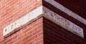
Location:Signpost on building still marks Albert Street (41st St.) and Winthrop Avenue (20th Ave.)
Flushing Avenue (Astoria Boulevard) northeast to Riker Avenue (19th Avenue). Named for a Steinway son.
What’s there now? 41st Street. The old Steinway Mansion can still be found on 41st Street near 20th Avenue.
Location: Flushing Avenue (Astoria Boulevard) northeast to Bowery Bay. Named for a Steinway son.
What’s there now? 42nd Street
Location:Flushing Avenue (Astoria Boulevard) northeast to Bowery Bay
What’s there now? 43rd Street.
44th Street, previously known as 14th Avenue, runs from Jackson Avenue (Northern Blvd) northeast to Flushing Avenue (Astoria Blvd.)
Location: Flushing Avenue (Astoria Boulevard) northeast to Bowery Bay. Later called 15th Avenue
What’s there now? 45th Street
Location: Jackson Avenue (Northern Blvd) northeast to Bowery Bay. Later called 16th Avenue
What’s there now? 46th Street
Location: Jackson Avenue (Northern Blvd) northeast to Bowery Bay. Later called 17th Avenue
What’s there now? 47th Street
Location: Jackson Avenue (Northern Blvd) northeast to Bowery Bay. Later called 18th Avenue.
What’s there now? 48th Street
Location: Jackson Avenue (Northern Blvd) northeast to Bowery Bay. Later called 19th Avenue.
What’s there now? 49th Street
Location: Pomeroy (37th Street) southeast to Old Bowery Bay Road
What’s there now? 19th Avenue
Location: One of Queens’ original roads, stretching from Calvary Cemetery on the south to North Beach (now occupied by LaGuardia Airport)
What’s there now? Pieces of it remain, such as Celtic Avenue in Sunnyside and 51st Street in Steinway
![]()
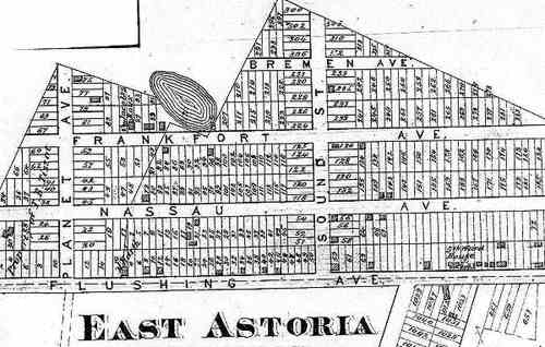
East Astoria was a very small community located on Astoria’s eastern edge, about where Astoria Boulevard and Steinway Street-43rd Street are now. It was developed earlier than the surrounding area, and when more streets were finally cut through, East Astoria’s small street grid survived. North-south streets were Planet Avenue and Sound Street, while east-west streets were Bremen Avenue, Frankfort Avenue (both of course, a sign of Astoria’s mostly German population during the 19th and early 20th Centuries) as well as Nassau and Flushing Avenues.
Over the decades, surrounding development swallowed up East Astoria, and its death knell as a separate community came when Robert Moses rammed through the Grand Central Parkway connection to the Triborough Bridge.
And yet…East Astoria hasn’t comepletely been killed. As you can tell from the present-day Hagstrom, two streets defy the grid to this day, 23rd Street and Sound Street.
Sound Street has never been completely conquered. Indeed… it’s important today, as it provides a means for traffic to cross the GCP.
Flushing Avenue became Astoria Boulevard, and Nassau Avenue was demolished for the GCP. Planet and Bremen Avenues have disappeared.
But Frankfort Avenue, later Frankfort Place, survives still, as 23rd Road between Steinway and Sound Streets.
And with this view of 23rd Road, perhaps you can still see the echoes from East Astoria. There’s no sidewalk, and the Connecting Rilroad can be seen in the distance as it has been since 1918.
SOURCES:
1938 Ritter-Swenson real estate map of northwest Queens
1910 Commercial Atlas of America, Queens section


