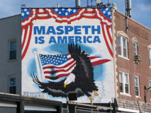
I worked on a Maspeth neighborhood page relatively early on, in about 2000 — for me it’s a typical Forgotten NY type of neighborhood — unserved by a subway line, ringed by cemeteries, expressways and parks that serve to somewhat separate it from its neighbors, Elmhurst and Ridgewood, from which it seems to have a distinct identity. Maspeth, generally, is more politically conservative than its surrounding neighborhoods and (not because of that) seems rather more self-contained — Maspeth versus the rest of New York City. I’ve always wondered what kinds of battles would ensue if the vibe from Williamsburg, just across Newtown Creek, would start to leach over the border. Two cultures could not be more different…
I skipped a trip out of town in 2009 — I was weakened for months while recovering from an aortic valve surgery in May and I was feeling good one week, lousy the next. What I did was schedule a day or two of vacation time each week from October through December. Plenty of time for Forgottening, no? Unfortunately, occasional fevers, bugs, backaches and rainy days happened to fall on most of the days off I scheduled. However, on this Monday in October the sun shone all day and I was feeling pretty well, so, doing what 99% of other New Yorkers wouldn’t think of doing on a sunny day off, I grabbed the camera and headed for Maspeth [google map]. Just kidding, Maspethians.
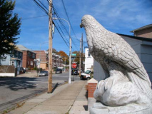
Federalist Triangle, Jay Avenue and Hamilton Place at the Long Island Expressway. When Henry Sternwas NYC Parks Commissioner in the 1990s he would often come up with interesting or fanciful names for parks or squares. This is one of them.
The Federalist Papers were a series of 85 articles and essays, advocating the ratification of the United States Constitution, appearing in the publications The Independent Journal and New York Packet from 1787 through 1788. Though the authors were not named at the time of publication it was later revealed that Alexander Hamiltonwrote 51 articles, James Madison 29, John Jay five; Hamilton and Madison collaborated on three. Since Jay Avenue and Hamilton Place meet here, quite coincidentally, Stern took witty advantage.
A gatepost to a former real estate development called Ridgewood Heights (Ridgewood proper is to the south and west of Maspeth) contains the chiseled name “Hyatt Avenue,” the former name of 65th Place, a main north-south thoroughfare.
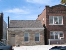
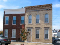
Even before I moved to Queens in 1993 I had an affinity with the borough, as I frequently bicycled in from Bay Ridge. A couple of times a year, I made my way into Maspeth, though mostly went through Southern Queens, Ozone Park, South Jamaica, Laurelton, all the way to Valley Stream. Sometime in the late 1980s — the years are hard to differentiate 20 years on — I was looking for a new apartment, likely from boredom (I tend to move only every dozen years or so) and an ad in the paper took me to this oddly-shaped (I think concrete) house at Jay Avenue and 66th Street. I did not take the apartment; it was too small, and I wound up not moving till 1993, to Flushing. But I have always been intrigued by this house, which had the same blue and white color scheme in the 1980s. A For Sale sign on the fence probably means that it won’t last too much longer. The cornice ornamentation and fancy window lintels mark it as very early 20th Century; Newtown, which Maspeth is a part, has been settled since the 18th Century.
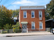
66th Street between Jay Ave and the LIE (actually the Queens Midtown Expressway) has a whiff of the Land That Time Forgot about it, as it’s dotted with several 2-story brick buildings, some charmingly and likely mistakenly built at an angle to the curbline. These all likely went up around 1900.
A small slice of Perry Avenue runs from the QME’s service road, Borden Avenue, northeast to 68th Street where it meets FDNY Engine 288. (Maspeth has a series of named avenues left over from the settling of Newtown in the 19th Century: Perry, Clinton, Hull, and Jay).
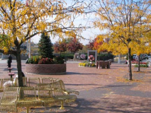
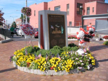
Maspeth Memorial Square, a broad plaza created in the 1950s at Grand Avenue and 69th Street when the QME/Long Island Expressway was built. The plaza includes a memorial to 19 firefighters from Engine 288 who perished on 9/11/01, the most at any firehouse in the city.
Mount Olivet Cemetery, accessed from Grand Avenue and Remsen Place as well as Eliot Avenue and Mt. Olivet Crescent, was first conceived at the home of James Maurice, one of the founding fathers of Maspeth, a prominent lawyer and US Congressman, in 1850, along with its original Board of Trustees. Following the fashionable practice of Brooklyn’s Green-Wood and The Bronx’ Woodlawn Cemeteries, Mount Olivet was built as a garden cemetery with winding grassy pathways. Its location on a promontory, 165 feet above sea level, made it a recreational as well as devotional attraction. The name honors the Mount of Olives outside Jerusalem. The New Testament story of Jesus’ Passion prior to His arrest and crucifixion takes place in the Garden of Gethsemane at the foot of the Mount.
Former Queens County Hotel, Grand Avenue and Remsen Place, built in 1851, served farmers from Long Island who were hauling wagon loads of produce to Brooklyn’s Wallabout Market. The hotel was one of many that sprang up on Grand Avenue, then a farm-to-market road. The building has been mixed-use for several decades.
64th Street and 58th Road. These appear to be runes but they are actually Roman letters drawn to look like runes. It says “The Flying Dutchman” in German.
Dresden Street
A dead-end mystery road can be found on 59th Avenue just west of 61st Street. Maps from the early 20th Century show it as Dresden Street (and the Post Office still likely uses the name) but it’s been purged from all modern maps; after World War I, cities such as Hamburg and Bremen found themselves similarly stricken from the city’s directories.
The Department of Transportation illuminates Dresden Street with one telephone pole lamp fixture. Two houses seem to have Dresden Street addresses, though one may be addressed on 59th Road.
At Eliot Avenue Mt. Olivet Cemetery enjoys its highest elevation. The Citigroup Tower (Lexington Avenue and East 53rd Street) as well as other skyscrapers are readily visible from here.
Eliot Avenue, normally a 4-lane juggernaut, narrows to two lanes as it forms the boundary between Mt. Olivet and All-Faiths (Lutheran) Cemetery. Eliot Avenue underwent extensive renovation in 2007 that widened it slightly.
Eliot Avenue is relatively new. It was constructed in the 1930s to form a direct route between Metropolitan Avenue and Queens Boulevard.
We’ve seen that this is one of Maspeth’s highest elevations. I was fascinated to see that Brooklyn’s Willliamsburgh Bank Tower at Flatbush Avenue and Hanson Place could be readily seen from this distance.
Eliot Avenue. The smart kids are inside playing video games.
Photographed October 2009; page completed December 7, 2009








1 comment
Hi, Anyone know the origin or meaning of Mazeu Street?