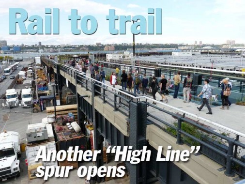
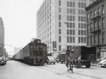
It’s not politically correct to like the High Line Park on the west side of Manhattan, which now runs from West 34th Street between 11th and 12th Avenues all the way south to Gansevoort and Washington Streets. It’s the high-concept park that has been built on what was previously called the West Side Freight Railway, built in 1934 to move goods between wholesale enterprises including bakeries, meatpackers, and products that were moved from ships on the Hudson River docks. The final freight used the tracks in 1980, and it sat rusting until the mid-1990s while Mayor Rudy Giuliani began to make some noise about demolishing it.
In a truly remarkable effort, an organization known as Friends of the High Line was able to recruit an all-star lineup of bright lights of entertainment, government and design, and the right publicity goes a long way — FOHL was then able to fund the purchase of the right-of-way and hulking iron structure from CSX Railroad and hire top names in innovative design to create a park two stories above street level. The model was Paris, France’s Promenade Plantée, created in 1993 on a disused rail line.
As I’ve said, while the glitterati like the High Line, the technorati or the bloggerati haven’t been as receptive. There are real concerns that businesses in the blocks surrounding the High Line have been forced out by rising rents: gas stations, auto repair, manufacturers, bodegas, barbershops. In turn these are being replaced by high rise apartment buildings that will, ironically, help ruin the view that High Line devotees enjoy today.
That being said, those same bloggers and columnists have an allergic reaction to tourists and out-of-towners, which are attracted to the High Line the way I am to pizzerias. Tourists, they say, are robbing New York of its innate Newyorkiness, as Times Square has been dragged out of its dangerous grindhouse and porno phase and one-eightied into a kid-friendly Disneytopia. However, pushy drunks making the daily scratch in dirty Elmo costumes are bringing back the edgy!
So:
–Do I enjoy walking the High Line? I don’t do it a lot, as it’s crowded a great deal and I like solitude, but as I said before, they had design geniuses in control of this thing and it looks as modern as anything you will see in NYC.
–Do I wish it had been reactivated for rail? It would have made a bangup western extension for the #7 train, or the L train from 14th Street. However, as a stipulation of the sale, CSX enjoined rail reactivation. You know what, it would have also made a nice overhead trafficway, when you think about it.
–Would I like western Manhattan to put thousands of people back to work on the waterfront instead of tearing down the docks (which because of container ports outside the city has been going on for decades) and Eloi-izing the whole space with riverfront parks and High Lines? Yes, but the world has changed, not for the better for nonprofessionals.

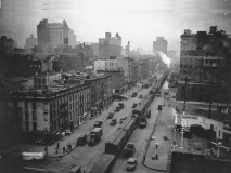
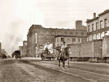
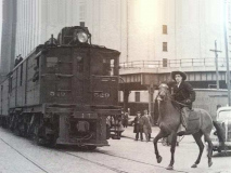
The story of the High Line begins in the 19th Century, when in 1849 the Hudson River Railroad was built from Midtown West along 10th and 11th Avenues south to a major market area, St. John’s Park Freight Terminal at Washington and Houston Streets. Though freights at slow speeds, preceded by mounted flagmen “cowboys” plied the avenues into the 1940s, the West Side Fright Elevated was built in part to lessen, and eventually replace, these freights and the cowboys.
Finally, the NY Central (today’s Metro-North) built an open cut rail line on the West Side that eliminated, along with the High Line, the need for at-grade trains.
photos from the Facebook group Manhattan Before 1990, posted by Main Tim.
This is a section of the High Line‘s official map. The new section just opened runs from West 34th Street south along 12th Avenue and then cuts east to join the already-opened section at West 30th Street and 10th Avenue.
I walked from 8th Avenue and West 33rd Street to the new High Line entrance on 34th and then, just the section they’re calling the Interim Walkway, but that’s probably a mistake and they don’t know any better, since ‘interim’ to me has the sense of ‘temporary.’ I went past the hole in the ground formerly home to the Cheyenne Diner, where many happy hours were spent accompanied by the Mohegan Burger. Yes, the Cheyenne Diner hamburgers were all named for Indian tribes.
This lamppost, west of 9th Avenue, is the last of a species of hybrid lamppost that was utilized only on West 34th Street from 6th Avenue west to 12th. It seems to combine the standard aluminum octagonal-shafted pole (first used in 1950 and the NYC standard since then) with a luminaire of a streamlined post used in several busy NYC neighborhoods, a minimalist post dubbed “shoebox” poles for the rectangular luminaire housing. You can see several samples on FNY’s first 5th Avenue streetlamps page.
34th Street received them in the 1980s and they have been gradually disappearing, except for this last Mohican.
On the west side of Midtown there are, or will be, a pair of north-south avenues not an original part of the numbered grid as devised in the 1811 Commissioners’ Plan surveyed by John Randel. One of these is Dyer Avenue, which runs intermittently from West 30th north to West 36th between 9th and 10th Avenue. It’s impossible to drive on its entire length, much less walk it, as its entire purpose is as an on and off ramp for the Lincoln Tunnel.
Sanna Feirstein, in her book Naming New York, says the avenue is named for Maj. Gen. George Rathbone Dyer (1869-1934) who was chairman of the NYS Bridge and Tunnel Commission and later, the Port of NY Authority, and was “a key figure in the creation of the Holland and Lincoln Tunnels.” (This is a point that Henry Moscow, in The Street Book, misses completely, saying the avenue was named for an early NYC mayor, William Dyre! That’s who Dyre Avenue in the Bronx was named for.)
Shown is actually what will be Hudson Boulevard East; Hudson Boulevard West will eventually appear west of the park, which will run from West 33rd-39th, with the new #7 train Flushing Line extension using two entrance-exit stations within the park. Since the park is part of the Hudson Yards Complex, I’m unsure whether it’ll be a private park open to the public, or whether it’ll be overseen by the NYC Parks department.
If you’re curious about these things, it looks like Hudson Boulevard will be using standard octagonal poles, but with the new-ish Helm luminaires, which first appeared in 2008.
However: the concept of a north-south interblock route between 10th and 11th Avenue is nothing new. I have a 1949 Hagstom showing a “Galvin Avenue” running in the same spot as Hudson Boulevard East and West eventually will, apparently serving as a conduit to and from the Lincoln Tunnel. In fact a shortened version of Galvin Avenue remained mapped into the 1980s. A short piece of the road was built, and runs between West 40th and 41st Streets next to St. Raphael’s Church and is usually choked with tunnel traffic.
Like Dyer Avenue, Galvin Avenue was built in 1937 and was named for another Port Authority chair, John F. Galvin.
Back in the late 1990s when I started writing and snapping for FNY, finding the High Line’s northern end was sort of like looking for the mysterious source of the Nile in darkest Africa. The tracks came to an end in a weedy, barbed-wired section of a parking lot adjacent to West 34th between 11th and 12th Avenues, in a spot where the Megabuses now load. (As an aside, since I am counting pennies I’m thinking of taking a Megabus trip to Boston or Philly, since I haven’t been out of town since 2010, when I was in Troy, NY — if anyone wants to review the Megabus experience, do so in Comments.)
These days, the north end of the High Line is a modest exit/entrance. The walkway appears pebbled, but has a firm carpetlike feel underfoot. Bicycles are banned in High Line Park, so strollers don’t have to dodge them as they do, say, on the Brooklyn Bridge.
I used my zoom lens to focus toward the Monastery of St. Michael the Archangel in Union City NJ, seen from the High Line along 12th Avenue. (When I worked on West 29th for a few years I’d see this far -off apparition and wonder what it was.)
The Monastery and Church of Saint Michael the Archangel is a state and national historic place in Union City, New Jersey. Formally opened in 1869 and completed in 1875, the grounds of the complex are bounded West Street and Summit Avenue between 18th and 21st Streets. The small street leading to its front entrance from the east is called Monastery Place. At one time the largest Roman Catholic church in Hudson County, it has since became home to a Presbyterian congregation while part of the grounds are used for housing and education. wikipedia
The church was designed by renowned ecclesiastical architect Patrick Keely. It is now on “Ten Most Endangered Historic Places in New Jersey” list.
This spur circles the west end of the massive Long Island Rail Road Penn Station yards between West 30th and West 33rd Street (foreground).
The Western Yard section of the Hudson Yards megacomplex will eventually be built here, on a deck that will cover three quarters of the railyards, which are expected to remain fully functional while the deck and high rise buildings supported by caissons drilled deep into bedrock, rise above them. By 2020, the view from here is guaranteed to be drastically different.
Cross streets have been provided on new railings built along the line, along with directional signs and highlights. The presentation materials and signage for the High Line, designed by Pentagram, have always had a forward-looking design and typographic treatment, no surprise because of the tons of money that has been put into the park.
(And now, the automatic: if only this amount of design professionalism could be imparted into rundown parks in the other boroughs.)
The West Side Freight Railroad was completed in 1934 and had similar streamlined Machine Age design that also found its way into the Independent Subway, which was under construction at the same time. The IND never had a lot of elevated stations (just two in Brooklyn) but we can imagine that if el stations were built for the IND Second Phase (in the works, but “derailed” by the Depression and WWII) they’d look something like what happened for the High Line.
Incidentally, the High Line had a twin brother: none other than the West Side Highway (properly named the Julius Miller Highway for a Manhattan borough president) which ran from lower Manhattan to West 72nd Street along West Street, 11th, 12th and 13th Avenues (13th was later renamed as a section of 12th) where it joined the Henry Hudson Parkway. It, too, opened in the early 1930s and shared several design elements with the elevated freight railroad, including exposed bolts and streamlined Machine Age lines.
Throughout its run, the city, always strapped for $$$, failed to maintain it adequately and it eventually became quite dangerous, as the builders never anticipated the sheer crush of car and truck traffic it would attract. After a section gave way in December 1973 most of it below 59th Street was demolished, though a very small exit spur , closed to traffic, is preserved at 72nd Street.
Thus, we’ll never know if the old West Side Highway could have been brought up to modern traffic grade, or even preserved as a park the way the High Line was. After the WSH was demolished (and the proposed Westway was scrapped) 12th Avenue gained a grassy center median and became a pedal to the metal speedway, albeit with a new Hudson River Park on its western flank. Among the changes were retro-Corvington style lampposts, like this one.
This gives you an idea of what the faux-pebbly surface looks like, even though it’s perfectly smooth.
Between 1980, when the RR was taken out of service, and the late 2000s when the park was built, the High Line “returned” to nature and the disused tracks became covered with weeds but also with some flowering plants, as seeds carried by wind and birds were dropped onto the trackways.
The designers have decided to leave the east section of the spur “as is” with the tracks and plants left in place, along with the original iron railings.
Argentinian artist Adrián Villar Rojas was commissioned to create artwork that was placed in the “wild” section, which he titled “The Evolution of God.” The art consists of cracked concrete blocks spaced along the walkway and, in a feature I didn’t notice when walking past, the blocks are imbued with various objects meant to crumble and deteriorate over time such as rubber and leather shoes.
Looking north along the High Line. Notice that the Pentagram design extends to the wastebaskets. The massive brick towers in the distance are exhaust vents for the Lincoln Tunnel. To the left are the tow yards for impounded vehicles that have broken traffic regulations.
A New York Water Taxi plies one of many routes in New York’s waterways. In the background are housing and hotel complexes in Weehawken. NJ east of the Lincoln Tunnel/US 3 helix, built in part by Hartz Mountain, the pet food people.
A look north from the High Line spur along West 30th Street across the soon-to-be decked LIRR Yards. The Silver Towers are seen in the distance.
A look east along the High Line spur, featuring metal/wood benches that employ the same exposed bolt scheme used on the overall structure. It could be one of the original metal beams. #10 Hudson Yards is rising in the distance.
A view of the businesses along West 30th Street under the High Line.
The north fence features a look at the “interim walkway”as well as a brief history of rail operations on the High Line and on the surface, as well as a look at the line just before it was rebuilt as a park.
The Pershing Square Beams is a children’s play area midway near 11th Avenue. The ‘beams’ are kid-friendly, are soft and have a considerable amount of “give.” They’re the elevated line’s original metal beams and stanchions coated in silicone. According to Friends of the High Line, “the area also includes a series of interactive elements developed exclusively… such as a rotating beam, periscopes, a gopher hole, and talking and viewing tubes.”
The Pershing Square moniker puzzles me, since the real Pershing Square is way uptown at East 42nd street at Park Avenue in front of Grand Central Terminal.
Another view of the railyard. Remember, the High Line from this point will be looking out over the western section of the Hudson Yards development which here will be a neo-Corbusian green area over a deck with a number of high rises.
A trio of photos from the exit-entrance staircase near 11th Avenue. Seen is the new Hamptons Market Place mini-mall on 11th Avenue and West 30th, an early Hudson Yards-High Line traffic attractor. (Yelp-ers with some of the usual widely divergent reviews.) Most of Hudson Yards’ shops and restaurants will be located on 10th Avenue.
To cross 11th Avenue the High Line developers added a slight hill over the original iron trestle to make Hudson River viewing better; also added were some display gardens on the medians.
The building next to the rising #10 Hudson Square Yards is the present home of the NY Daily News. WNET, NYC’s Public Broadcasting affiliate, the Sky Rink and Hagstrom Maps’ former headquarters were also located in the oddly angled building at 10th Avenue and West 33rd Street.
Hopefully, the gas station and auto electrics shop on 11th and West 30th will keep going strong, but they’re the kids of paces that have been pushed out of 10th avenue along the High Line route south of here by developers seeking high rises full of expensive apartments.
A closer look at the 11th Avenue Bridge with its plantings, 2-foot elevation and side benches.
Looking north on 11th Avenue in a transitional phase. By 2020 both sides will be lined by the massive Hudson Yards project.
A short portion of the actual trackbed, complete with rails and tracks, has been turned into a walkway. Some of the rail switches and “frogs” have been left in place (not shown here).
There’s still a lot of engineering being done under the trestle, but take a look at how the previously rusty iron has been given a new paint job and even the concrete has been nicely repointed. (Compare that to stretches of the #2 elevated line in the Bronx that haven’t been painted since the first George Bush administration.)
There is still one remaining High Line chunk that has not yet been developed, a short spur crossing 10th Avenue at West 30th and then dead-ending. I don’t know its original purpose. For now, it seems to have found use for storage. I don’t know if there are plans to open it to the public. While #10 Hudson Yards is still being constructed, it will likely be left alone.
This page states that the spur originally brought railcars into the massive Morgan Post Office Facility. It, too, will be developed as an elevated garden, but I imagine that part will be done after #10 Hudson Yards is finished.
The High Line also has its own L-shaped style of lamppost, though it’s used infrequently on staircases that descend directly below the trestle.
When finished, #10 Hudson Yards will resemble the taller building with the slanted roof in the illustration.
Modern art installation at the north end of the High Line second section that opened in 2011. I’m no critic, but that resembles one of Lovecraft’s minor gods.
When finished #10 Hudson Yards will be a towering glass-fronted building at the elevated park’s left turn at West 30th.
Treated myself to an elevator ride. The windows are tinted green.
Took a look at the newly painted trestle and the still-unused portion over 10th Avenue. I thought I had read rumblings about a public plaza on the spur straddling 10th avenue, but that seems absent from the latest dispatches, and its future may be undetermined or it will not be opened at all.
The south end of Dyer Avenue, a one-block stretch from West 30th to West 31st. It connects to an open-cut trafficway leading to the Lincoln Tunnel.
Flag shield and terra cotta cornucopiae on the old James Farley post office building at West 30th and 9th Avenue. Eventually, someday, the old post office is supposed to be converted to a new Penn Station, although funding is murky.
10/26/14
