
Late November 2014. I decided to walk most of the length of one of those Bronx roads with classic names I hadn’t paid all that much attention to, yet its name harks back to a lot of history… of course, I hope its name never changes. It’s an east-west route running from Mosholu Parkway east to where the Hutchinson River Parkway, Bruckner Expressway and New England Thruway all converge, and serves as something of a fast and furious feeder road for all three in its easternmost stretch.
The route, of course, is Gun Hill Road (I know it’s East and West, but I’ll just say Gun Hill Road for expedience’s sake).
My route today was pretty much straightforward (west on Gun Hill Road and Van Cortlandt Park South to Riverdale), but here’s the Google Map, regardless.
When I left off at the edge of Bronx Park in Part One, I was ready to talk about Gun Hill Road’s four consecutive bridges. By “consecutive” I can say that they are parallel to each other with no intervening streets separating them. They span roadways, rivers and railroads, and I cannot think of any other location in NYC where a road passes over four straight bridges.
The first two of these bridges are the oldest and most interesting of the quartet; traveling east to west, they are brick bridges dating to 1918, crossing the Bronx River and the roadway that marks the east edge of Bronx Park, Bronx Boulevard. (South of Burke Avenue, Bronx Boulevard becomes Bronx Park East.)


The first bridge crosses the Bronx River, New York City’s only true river, which begins as a trickle in Westchester County and empties into the East River (which is actually a tidal estuary). It formerly turned west and met the Hudson River, but a glacier impeded its progess there during the last Ice Age and the river was thereby diverted south. When Swedish pioneer Jonas Bronck settled in the area of the river in the mid-1600s, the river, which had gone by several Native American names, became known as “The Broncks’ River,” and the “the” has stubbornly remained as a prefix for Bronx borough, as well. Industrialization of the 1800s and 1900s turned the water brackish and unsustainable for life, but groups such as Bronx River Restoration and Bronx River Alliance have helped bring it back. Kayakers can now regularly be seen there, and it looks as wild as it must ever have been on its course through the Bronx Zoo and New York Botanical Garden. New parks have also sprung up along its banks, as well as reconstruction of older parks such as Starlight Park in West Farms.


These bridges are functional in design, with simple brick pillars and arches. They are fairly identical as they take Gun Hill Road over the Bronx River and just west of it, Bronx Boulevard.


What makes them interesting are the inscriptions on the decorative pillars that appear at he beginnings and ends of both bridges. They are marked with the letters “BRPR” and the date 1918. According to the late Bronx historian Bill Twomey, the letters stand for “Bronx River Parkway Reservation.” The Reservation parallels the Bronx River from the New York Botanical Gardens north to Kensico Dam, Valhalla, in Westchester County. It’s a 15.5-mile swath of parkland designed in the early years of the 20th century by the Bronx Parkway Commission.
Architect Charles Stoughton designed many of the bridges and other architectural elements in the BRPR, including this one. With his brother Arthur Alexander in the firm Stoughton and Stoughton, he also designed the Soldiers and Sailors Monument on Riverside Drive and West 89th Street.

Next in Gun Hill Road’s parade of bridges is the one that spans the Bronx River Parkway, constructed between 1907 and 1925 between the Sprain Brook Parkway in Bronxville and Kensico Dam Park in Valhalla in Westchester County and then extended gradually south from Bronxville to Soundview in the Bronx with the southernmost section opening in 1952.


4th and last in the parade of bridges spans the Metro-North Harlem Line tracks. There has been a railroad here since the early 1840s, when the New York and Harlem Railroad, incorporated in 1831, reached north to White Plains; by 1863 the line became the New York Central and Hudson River Railroad when Commodore Cornelius Vanderbilt had attained control of all the various railroads connecting New York, Albany and Buffalo; the railroad became known as New York Central RR in 1935. The line was administered by Penn Central by 1969, Conrail in 1976, and finally by the Metropolitan Transit Authority in 1983. (Railroad history is convoluted and complicated; see this wikipedia entry for a fleshed out history of the Metro-North lines connecting NYC and Westchester County and Connecticut locations.)
One of the Bronx’ major colonial-era roads (Williamsbridge Road), a train station, and a major intersection, were named for a bridge operated by farmer John Williams crossing the Bronx River at today’s Gun Hill Road in the early 1700s. The settlement that sprung up near the bridge became known as Williams Bridge, later spelled as one word.


An elevated train used to run on Gun Hill Road between Webster Avenue and White Plains Road. The most tangible reminder of this is a shorter-than-normal Deskey pole at the off ramp of the Bronx River Parkway, the better to fit under the el structure. Until 1973, the last remnant of the Third Avenue El ran from The Hub at Third Avenue and East 149th Avenue north on Third and Webster Avenues and east on Gun Hill Road to a connection with the White Plains Road el, now serving the #2 train and sometimes the #5.
Passengers could obtain a free transfer at the Hub from the #2 and #5 by going upstairs at the East 149th Street stop. By 1973 the then- Transit Authority determined that this service was redundant (though now there’s no north-south el trains in the Bronx between the Grand Concourse and Westchester Avenue/Southern Boulevard) and scrapped it.


This photo from 1973 shows the el turning from Webster Avenue east onto Gun Hill Road. Service would end later that year and most of the structure would be removed by the next year, though a second deck of platforms on White Plains Road serving the Third Avenue El would remain in place until 2004.

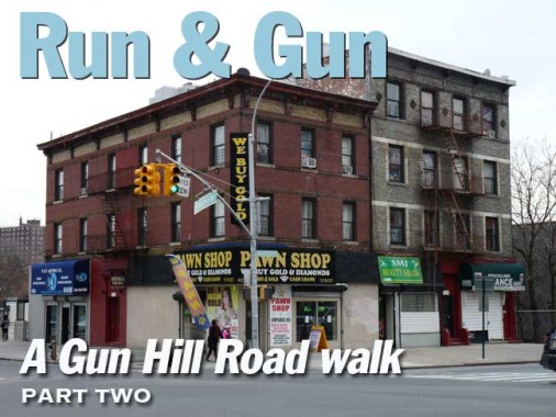
Tiny building on the NW corner of Webster and Gun Hill Road with a French Second Empire-style mansard roof with dormer windows is almost engulfed by secondhand tires.

This building on the SE corner with the pawn shop can also be seen behind the el in the above photo. The Metro-North railroad is behind both buildings.


Moving west a few blocks to Hull Avenue, on the NE corner is a decades-old “privilege sign” that was sponsored, in this case, by Breyer’s Ice Cream, whose old logo is on the sign. William Breyer founded the company in 1866 in Philadelphia. Breyer’s was sold to what became Kraft in 1926, and was acquired by Unilever in 1993; Unilever proceeded to change the formula, and included additives, changing its taste and texture (when I was a kid Breyer’s was famed for having flecks of vanilla beans in its vanilla ice cream).
This sign is a classic case of “it gets the job done, why fix it?”
Come to think of it, my whole career has been a struggle between my desperate attempts to leave well enough alone vs. others’ desperate desires for change!

One of the many Moderne buildings along this stretch of Gun Hill Road at Perry Avenue. Apartment buildings of this type were constructed between 1928 and 1938.


Kings College Place runs for one block between Gun Hill Road and East 211th, at the southern end of Woodlawn Cemetery, as well as the Gun Hill Monument, located just inside the fence.
This is one of two NYC streets, or former streets with still-existing signs, that are reminders of King’s College, established in 1754 by royal charter of King George II. The first classes were held in a schoolhouse adjoining Trinity Cemetery on Broadway and Wall Street, with eight students in attendance. After changing its name in 1784 to Columbia College following the establishment of American independence, the school moved around Manhattan several times before becoming Columbia University, Manhattan’s entry into the Ivy League, and moving uptown to its present campus in 1897.
There is one more reminder of King’s College, then Columbia College, downtown. A chiseled street sign at West Broadway and Warren Street marks College Place, one of West Broadway’s former names. In 1760, Columbia moved into its own building on land donated by Trinity Church at present day Park Place, and then sold that property and moved uptown to East 49th Street in 1857, and the old Park Place building was demolished in 1860. The sign, though, will likely be there as long as its building exists.


The intersection of Bainbridge Avenue and Gun Hill Road is dominated by Montefiore Hospital, which dominates the local economy, and the Henry and Lucy Moses Research Institute (left). Named for a longtime hospital president who teamed with his wife in philanthropic work, the Research Institute was a 1965 project by architect Philip Johnson.
The Montefiore Home for Chronic Invalids was founded in 1884 by Jewish philanthropists who wanted to do something for chronically ill people whom other hospitals of the day would not help. Montefiore quickly expanded and began an age of delivery system innovation, medical education and scientific research that it continues today as a premier academic medical center.
It was in 1890 that Montefiore was among the first to test tuberculin for the diagnosis of tuberculosis. In 1901, asthma patients at Montefiore were treated with adrenalin chloride—one of the earliest clinical uses of adrenalin.
Groundbreaking milestones continued with the development of the cardiotachometer in the 1920s, an innovative instrument to measure the heart’s beat. The device is now on display in the Smithsonian Museum. Montefiore would also build the foundations of its commitment to innovative health care when, in 1905, it established one of the nation’s first hospital-based departments of social work to meet the psychosocial and home-care needs of patients and their families. In 1912, Montefiore expanded its services and built a new hospital in the Bronx. Thus began a new era for Montefiore as it began partnering with the borough to create a world-class healthcare model accessible to anyone in need. Continuing to blaze trails, the first woman joined Montefiore’s house staff in 1916. — montefiore.org

In addition to the pizza palaces, Dunkin’ Donuts, and pharmacies lining Gun Hill Road opposite Montefiore is a surviving Blimpie, just west of Rochambeau Avenue, which I have filed away in my head for future reference. Blimpie makes a superior sub compared with Subway, which nonetheless has wrested the sub market away from Blimpie, unjustifiably, in the NYC area. My current Blimpie of choice is the Russian Tea Room of Blimpies on Washington Street in Hoboken, but I note all the extant locations.

Gun Hill Road intersects three subway or el lines and two have a Gun Hill Road station. The one nearby this locale is, however, named for Mosholu Parkway.
The #4 train, which runs on Lexington Avenue in Manhattan, runs on Jerome Avenue in the Bronx, named for stock speculator and financier Leonard W. Jerome (1817-1891) who built the Jerome Park Racetrack, whose grounds is now occupied by the Jerome Park Reservoir. Jerome’s wish was to bring back horse racing to prominence after its abolition during the Civil War. The racetrack was a lavish affair with a grandstand seating 8000, a large dining room, a magnificent ballroom, polo, trapshooting and sleighing and skating in winter; the track also boasted clubhouse accommodations comparable to a luxury hotel. The Belmont Stakes, now at Belmont Raceway in Elmont, Nassau County, were held at this track between 1867 and 1890.
Jerome’s Brooklyn-born daughter, Jennie (1854-1921), was taken to Paris in 1867 by her mother to mingle with society; in 1874 she met Lord Randolph Churchill, they married, and their son, Winston, became England’s wartime prime minister.
The el, meanwhile, was constructed in stages and opened in 1917 and 1918. Most of Jerome Avenue is shrouded from sunlight by it, except for a southern stretch between the Macomb’s Dam Bridge and River Avenue, and a shorter stretch further north between East 198th Street and Bedford Park Boulevard.
Just as 5th Avenue (for the most part) is the divider between East and West numbered streets, Jerome Avenue assumes the same role in the Bronx. It was laid out as a plank road in 1874 and became a broad, tree-lined boulevard before the el arrived.


A wet November snow had fallen a few hours before I entered Van Cortlandt Park’s southeast corner at Jerome Avenue and Gun Hill Road.
Van Cortlandt Park is marked by rocky outcroppings made mostly of gneiss, a metamorphic rock with a distinctive banded texture. Streaks of mica can be found in the rocks, as well as quartz. Van Cortlandt Park’s Northwest Forest contains the park’s older-growth trees, featuring red, white and black oak, hickories, beech, cherry birch, sweetgum, red maple and of course, the incredibly tall and straight tulip trees. Fauna fans won’t be disappointed either as owls, bats, chipmunks, woodchucks and large gypsy moths, rabbits, raccoons, opossums and coyotes are all here and accounted for.
Van Cortlandt Park is divided by no fewer than three major roadways, the Henry Hudson Parkway, the Mosholu Parkway and the Major Deegan Expressway, yet is large enough to accommodate them all without losing its distinctive rural character. The 1997 John Muir Nature Trail as well as the Putnam Railroad and Croton Aqueduct Trails run through the park. It’s the Bronx’ second-largest park: Pelham Bay Park is NYC’s largest.

Gun Hill Road is nearly straight from Jerome Avenue east to the Hutchinson River Parkway, but it zigs and zags gently here to match the southern end of the park.


This, the west end of Gun Hill Road, or rather the west end of West Gun Hill Road, boasts several Moderne apartment houses similar to those arrayed along the Grand Concourse. What I admire most about them are the perpendicular corner windows.

No-barbecuing sign at Mosholu Parkway. These NYC Parks signs have a representation of a maple leaf with lettering in the Palatino font and are usually brown with gilt letters. Obviously though, the ones warning against fire hazards are colored red.


The past couple of decades have been a golden age for bicyclists in NYC as thousands of miles of bicycle lanes (protected and unprotected) have been added. The Gun Hill Road-Mosholu Parkway intersection also crosses the bike path associated with the Bronx Greenway, which runs from Van Cortlandt Park, southeast on Mosholu Parkway, Kazimiroff (Southern) Boulevard, Bronx Park East, and Pelham Parkway into Pelham Bay Park.

Mosholu Parkway, whose Native American name means “place of small stones.” I discuss both Mosholu and Pelham Parkways on this FNY page.

West Gun Hill Road’s western end is at Mosholu Parkway. However, a narrow. one-way road, Van Cortlandt Park South, runs along the park’s southern border west to Broadway, though it’s interrupted (see below).
St. Patrick’s Home, a facility for the aged and infirm, was founded by Carlemite Roman Catholic Sisters in 1929; this new building at the park’s edge was opened in 1989.

Gneiss is nice. Rock outcroppings like this, mainly composed of gneiss rock, were left as a glacier retreated thousands of years ago. In some cases they were dynamited to clear property, but in many of Manhattan’s parks from Central on north, and in Bronx parks as well, they were left in place as decorative elements. Don’t be surprised to see them in empty lots on side streets in upper Manhattan and the Bronx as well.


Between Mosholu Parkway and Gale Place, Van Cortlandt Park South has been given a set of retro Type F posts. This design, in a shorter, thinner-masted version, was mostly used on Manhattan side streets from 1910 to 1950 or so, but a newer, more robust design was commissioned by the Department of Transportation and has been used on 8th Street in Greenwich Village as well as Wyckoff and Metropolitan Avenues in Brooklyn and Queens.


Some of the Amalgamated Houses can be seen walking west along VCPS. I’ll quote from my notes for ForgottenTour #37, which explored this section of the Bronx in August 2009:
The Amalgamated was the first union-sponsored housing coopwerative in the United States, sponsored by the Amalgamated Clothing Workers Union under the leadership of Sidney Hillman (for whom Noble Avenue was renamed in 1950) and created by Abraham E. Kazan, “the founder of cooperative housing in the USA.” The first buildings between Sedgwick Avenue and Van Cortlandt Park South went under construction in 1927 and the latest additions were completed in 1970.
The structures were built inexpensively and with no frills, but they produced an attractive and comfortable environment for families and community interaction. Plus they had style. Similar to housing projects of today, they were a series of interconnecting high-rise buildings, organized around communal public space. But back then, the developer and the architect made an effort when it came to design. The public spaces were green spaces with paths, shaped gardens, and fountains. The buildings were designed in a Tudor style with large windows.
The houses are a remnant of a period (prior to a time when full knowledge of the butcheries of Joseph Stalin had become fully known and the totalitarian governments that had featured socialism were duly reviled) when Socialism and Communism were considered viable alternatives to the purely capitalist system espoused in the USA.
Amalgamated is one of 3 housing cooperatives in the northern Bronx created in the 1920s, along with the Sholem Aleichem Cooperative on Giles Place (we visited it on the tour) and the United Workers Cooperative Colony (Allerton Coops) which still displays the hammer and sickle symbol over some of its doorways.


For one block between Gale Place and Van Cortlandt Avenue West, Van Cortlandt Park South (yes, there are a lot of Van Cortlandt place names around here) is interrupted by a few flights of steps. Before the 1980s or so, VCPS was shown as a continuous line on most maps, but the grade is so steep here, I doubt this was ever a road open to motor traffic.

West of Van Cortlandt Avenue West, VCPS again becomes an important two-lane road. This photo, looking east, shows Van Cortlandt Avenue West on the right and the onramp to the Major Deegan Expressway on the left. You can also see the staircase.

The demise of the Deskey lamp has been greatly exaggerated. While they haven’t been manufactured for over 30 years, so many of them were built in NYC that it will take decades to replace them, though the ones whose parts don’t work anymore are removed. This one at VCPS and the Deegan is notable because it still has its unique-design orange fire alarm light cap at the top of the shaft, which itself does not light up anymore.


As Van Cortlandt Park South crosses the Major Deegan Expressway, it is also bridged over the “ghost tracks” of the old NY Central Putnam Railroad branch. This branch used to carry passenger traffic into Westchester County, though that was discontinued in 1958, with the line continuing as freight until about 1980. The right of way exists as a nature trail in Van Cortlandt Park, and the skeleton of the park’s RR station still stands. A more comprehensive history of the line can be found here.
The Major Deegan Expressway continues to the Bronx-Westchester border, where it becomes the NYS Thruway and runs to northern and western parts of the state. It is more properly known as the Thomas E. Dewey Thruway, after the midcentury mustachioed NYS governor who ran unsuccessfully for President against both FDR and Harry Truman.
Putnam Avenue West was apparently named for the railroad (it is located west of the railroad; there is no Putnam Avenue East).


West of the Deegan I found one of the largest unbroken expanses of concrete you’ll find in a NYC park, mysteriously circled with park benches. I’m stumped as to what Parks had in mind here. It’s accompanied by a park path called John Bachman Way, named for a former Bronx Parks Chief of Operations.


The south side of VCPS features the sprawling complex of the Visitation of the Blessed Virgin Mary Church (most Catholics recognize the abbreviation “B.V.M.” The parish was established in 1928 but when the Deegan was constructed in the early 1950s, a new, aggressively Modernist church building was constructed in 1953 (I thought it looked much younger than that).
Many Catholic churches bear this name, which honors an incident found in the Gospel of Saint Luke in which Mary, pregnant with Jesus, visits her cousin Elizabeth, who is also pregnant with St. John the Baptist.

The church still has its old announcement board, perhaps left over from the older building.

A sculpture of the Visitation on the front lawn of the adjacent rectory makes it look as if the two cousins are trapped in a concrete slab.

This container, located on a side door of the church building, was probably used to dispense holy water (water blessed by a priest) but it looks suspiciously like an ashtray, and I imagine a number of people have assumed that as well.


Review Place runs north-south for a couple of blocks, ending at Van Cortlandt Park South. It is close to the park’s parade grounds and the name may have something to do with military marching bands making their way into the park. A similarly-named street in Blissville, Queens, Review Avenue, was home to processions on their way to the Calvary Cemetery gate.

Twin Oaks Triangle was built from a previously nondescript traffic triangle at VCPS and Broadway in 1989. The “twin oaks” are probably the ones on the right of the picture.


Just within the park entrance opposite Twin Oaks Triangle is a monument to a coyote found on the Major Deegan (after it was run over) in 2005, marking the first sighting of a coyote in NYC since 1946. Since then the wild canines have been reported, captured and set loose in less urban settings in several other locations around town, as they are apparently expanding their range.


Mention Broadway to an out-of-towner and the street’s elevated train, which shadows it from West 215th in Manhattan north to West 242nd in the Bronx isn’t the first thing that (s)he would think of. This is a historic route, though, as it was the first elevated branch built as the extension to a below-ground route. The original NYC subway ran from the now-closed City Hall station north, west and north again to Broadway at 145th Street in 1904, and was then extended in stages north, with the el part opening for business in 1908.
The Swiss chalet-style stations opened that year have stayed mostly intact.


West of Broadway, Gun Hill Road/Van Cortlandt Park South’s name changes once again to West 240th, which runs for a few blocks to Irwin Avenue. On the north side is one of NYC’s hidden soccer pitches, well-known to local clubs but not to the public at large, much like Ridgewood’s Metropolitan Oval. In 1926 the grounds were purchased by the Gaelic Athletic Association of Greater New York, which built a soccer field and a dance hall. This is also one of NYC’s little-known classic rock venues of the 1970s, as the Grateful Dead, Chicago, Edgar Winter, Johnny Winter, Jefferson Airplane, Allman Brothers Band, Ten Years After, Yes, ELP, Mountain, The Beach Boys, Humble Pie and Deep Purple all appeared here (pretty much the WPLJ-FM playlist in 1975).
The grounds were purchased by Manhattan College in 1991. The venue’s importance has dwindled in recent years, but it still is home to soccer, hurling and Gaelic football, both men’s and women’s teams. The dancehall/rock concert palace is now used for catering.


Having walked most of Gun Hill Road and the streets west of it, time to kick it in the head for another day, but not before noticing that some of the old ironwork from the West 238th Street station’s original days has been retained. The old potbelly stoves have been long replaced with electric radiators and Helvetica has replaced the old navy and white signs on the platforms.
2/8/15