 The Roosevelt Avenue IND station is a busy interchange serving Queens Boulevard local routes (M, R) and express routes (E, F). There’s also a transfer to the Flushing Line here.
However, there was once a plan to make the line even busier. As part of the unbuilt IND Second System, a spur was once going to branch off from this station, run southeast along various streets in Maspeth and Glendale (Fresh Pond Road and Central Avenue were proposed) as both a subway and an el, and ultimately hook up with the Long Island Rail Road Rockaway Branch, where it would travel alongside the LIRR across Jamaica Bay to territory now claimed by the A train.
What happened? The Depression, which worsened in 1936 and 1937, and World War II, which claimed materials that would be going toward the line. After WWII, the Age of the Auto had begun, and surface lines and subways were suddenly out of fashion. However, a subway route to the Rockaways did happen. When a wood trestle owned by the LIRR burned in 1950, the railroad sold the line to the Transit Authority, which rebuilt the bridge as well as a connection from the A train to the Liberty Avenue El, and then paralleled the Rockaway tracks. LIRR service on the branch ended in 1962, but the A train still uses part of the route. Maspeth and Glendale, however, have never gotten subway service.
A legacy of the planned IND Rockaway expansion was the tiled sign formerly seen at a staircase in the 65th Street station, above left. Perhaps as result of my showing it in FNY, it was removed soon after I posted it in 2000.
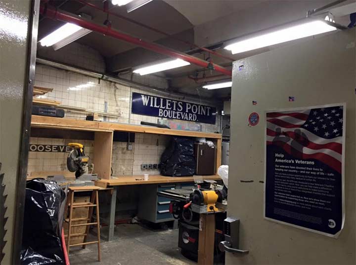
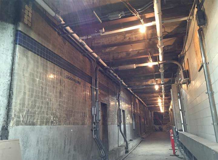
Another legacy of that route is in a police station and crew room at Roosevelt Avenue. One of those upper level spur platforms was completed, with tiling and signage. These survive intact today. Some former enamel signs from the Willets Point Blvd. station on the Flushing Line have been placed there but make no mistake, this is at Roosevelt Avenue.

This photo shows you the color tile band and small black and white Roosevelt Avenue signage. No large color IND Roosevelt Avenue plaques were made for this station; the lower level, in use, has island platforms and so the large signs don’t appear. The corridor you see would have had a trackway roadbed running in it.
Photos courtesy Jason Brown
2/3/16

4 comments
I often work at this station & just recently had the privilege to walk through this area. It immediately brought me back to your unused stations page from years ago. Unfortunately, I had a lot of gear & was in a rush, so wasn’t able to gawk, or take pictures. But it gave me such a tickle to be there.
I’d love to check this out sometime. Let me know if you ever want to explore it! alt0idego@gmail.com
Just want to clarify the dates shown for the service changes on the old LIRR Rockaway Beach Branch across Jamaica Bay. When the line reached the Queens mainland, it continued north to the current LIRR Main Line at White Pot Junction, about a mile west of the current Forest Hills Station. At that point the Rockaway Beach tracks swung west and paralleled the current four tracks on the Main Line until Win Tower [gone since a 1974 fire], about a mile east of Woodside Station. There the Rockaway Beach tracks were merged into the Main Line and the Port Washington Branch, which joined its sister branches at Win to travel to/from Penn Station. The Rockaway Beach Branch also had a track connection to and from the LIRR Atlantic Avenue tunnel as well, allowing trains to operate directly to and from today’s Atlantic Terminal.
The IND subway builders had been eying the LIRR Rockaway Beach Line for years. Besides the proposed service to and from Roosevelt Avenue another future subway link was created just east of the 63rd Drive Station, which is only about three blocks from White Pot. In 1933 the proposed plan would have seen NY City buy the LIRR Rockaway Beach Branch from White Pot southward, substituting IND Queens Boulevard subways for LIRR trains across Jamaica Bay. The same factors that killed the Roosevelt Avenue upper level spurs also killed the 63rd Drive connection.
The 1950 trestle fire changed everything. LIRR trains never used the old Jamaica Bay route again. NY City bought the LIRR branch in 1952 with the intent of connecting it to the Queens Boulevard subway at 63rd Drive and to the A train at Liberty Avenue, but ultimately decided to only connect to the A train because of huge ridership growth on the Queens Boulevard E and F routes. LIRR trains served Rockaway until October 1955 by using a roundabout route through Valley Stream. IND subway service to/from Rockaway began in June 1956. The old LIRR branch north of Liberty Avenue remained under NYC ownership but was leased back to LIRR to permit two daily round trips between Ozone Park and Penn Station (became a single round trip by about 1959, and was ended in 1962). Since 1962 the old right of way has sat unused, overtaken by natural vegetation.
Just to add to Andy’s remarks: Since the line was abandoned north of Ozone Park in 1962, several landowners whose properties adjoin the right of way have seen fit to clear away some of the vegetation and extend their backyards into the right of way. Some apartment buildings constructed since the end of service on adjoining pieces of land have parking lots that extend over the right of way. The underground LIRR Atlantic branch, which runs from Jamaica under Atlantic Avenue to East New York and points west, had a subway-like station at Woodhaven. This station had two side platforms and was closed for low usage in 1976. Until 1962, there had been spurs connecting that line with the Rockaway Beach line, which ran directly overhead, above ground. Those spurs were closed in 1962. The above-ground space where the Rockaway Beach-bound spur once ran is now occupied by a school bus company and the space is filled with school buses.
There has been talk recently about converting the right of way into an above-ground park, akin to the High Line Park in Manhattan. This would be called the Queens Greenway. Transit advocates and some local politicians have advocated for restoration of service on the line. In the meantime, the line sits quietly disintegrating. The concrete overpasses above streets like Union Turnpike and Metropolitan Avenue in Queens are crumbling due to age and a lack of maintenance for the past 54 years.