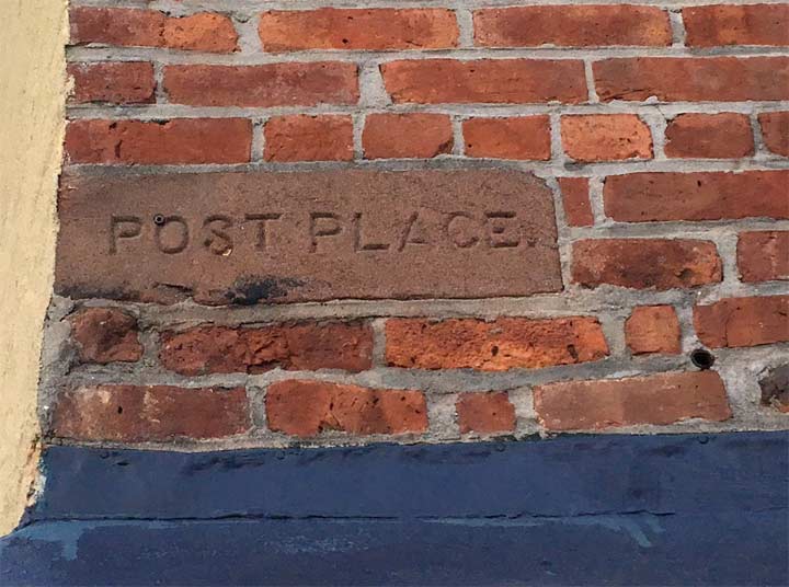
ForgottenFan Nathaniel Sasson sent me a conundrum, a chiseled sign on Prospect Southwest at its northwest corner with Reeve Place. At first, I thought this was a former street name, as these chiseled street names are fairly common. Sometimes they feature the current street name, sometimes the former name.

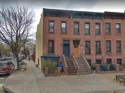
That corner is the southern end of a group of attached modest 3-story brick dwellings. I call them the “bread and butter of residential Brooklyn architecture” because you find buildings like these in older Brooklyn neighborhoods by the hundreds. Sometimes, the entrance stoops only have three steps, but here, there are nine. Midblock, there is a newer 4-story building, and one of the buildings has a bay window, but by and large, these are the same as they were when first built.
The “Post Place” sign in question is located just above the blue ledge on the first floor, facing Prospect Park Southwest. Could that street once have been called Post Place?

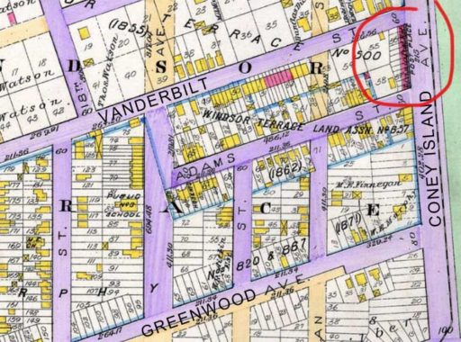
The answer is no. As this excerpt from an 1890 Robinson atlas of southern Kings County indicates, while Prospect Park SW was once a northern extension of Coney Island Avenue, and Reeve Place was once Adams Street, the “Post Place” sign refers to the row of brick buildings itself. They must have been built as a unit by the same developer.
Check out the ForgottenBook, take a look at the gift shop, and as always, “comment…as you see fit.”
1/30/19


5 comments
A search of the Brooklyn Eagle from the 1880s has ads referring to these houses by Post Place addresses. (Inquire at 11 Post Place, etc.) They were advertised as new homes in 1883, at a monthly rent of $20! The 1898 E. Belcher Hyde atlas shows Coney Island Avenue addresses north of Vanderbilt Street increasing southward, with No. 30 at the corner, and picking up again south of Reeve Place (Adams St) in the 40s. In between, the Post Place numbers commence at No. 1 at the corner of Vanderbilt, so this seems more like the “Places” in Manhattan that would “interrupt” a street for a block or so (sometimes on only one side). At some point the houses on Coney Island Ave/Prospect Park Southwest were renumbered, and Post Place vanished as a separate address.
This row also features a private rear alley running between Reeve Place and Vanderbilt Street. There was a matching chiseled sign at the corner of Vanderbilt Street, but at some time an owner “lovingly” chiseled out the name Post Place. The signs may have originally been chiseled on the Vanderbilt and Adams (Reeve) sides, but the sides of the corner houses have been stuccoed and painted, so if they’re there, they’ve been covered up for many years.
As a child I lived at 74 Reeve Place, just around the corner. One of the things I remember were the embossed “bulls eye” motifs in the masonry railings on the original stoops, each of which would get a poke from us kids as we walked by.
Google Street View gives a nice view of that rear alley and the cars parked on it. There seem to be a couple of garages too. I’ll bet that private off street parking nicely boosts property values.
Vanderbilt St is the border between Brooklyn and Flatbush/ New Utrecht. Was Post Place named for an old boundary marker?
Indeed, Prospect Park Southwest was originally Coney Island Avenue. Its house numbers leave off at 199 on the north side of Park Circle and continue from 300 on Coney Island Avenue on the south side.
If Post Place predates Coney Isand Ave, I suspect that it may refer to hitching posts for horses on the Coney Island plank road/railroad. A New York Times (1860) article reported that the Railroad was building stables for 200 horses in 1860 at he foot of 15 St to service the horse drawn rail cars. Horses would have been taken from the stables and posted for service