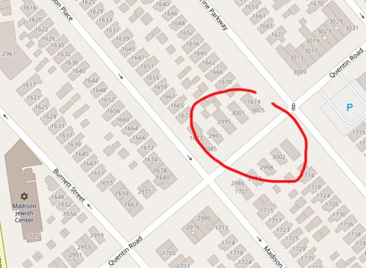
I was stumbling around Marine Park on my way to a funeral parlor earlier this week when I noticed something definitely wonky about the house numbering. This is a neighborhood dominated by a numbered and lettered grid, with the north-south streets bearing numbers, and the east-west streets getting letters. These streets originally belonged to the formerly independent towns of Flatbush, Flatlands, Gravesend and New Utrecht in Kings County, and the simple letter/number system was devised in 1874 by a Kings County entity called the Town Survey Commission. Here’s an early map of southern Kings County.
Well, in Marine Park, then as now, the street grid runs northwest to southeast, in contrast to the overall rough north-south orientation. This meant that East 31st through 37th make a turn, from N-S to NW-SE. The commissioners, therefore, laid out a number of named streets to fill the space between Nostrand Avenue, which stands in for East 30th, and East 31st: Stuart, Burnett, Madison Place (formerly Marsh) and Marine Parkway (formerly a southeast jog of East 30th).
The house numbering in southern Brooklyn is fairly straightforward: as in Queens, the first two numbers correspond to the cross street, thus buildings along Quentin Road between East 28th and 29th begin with 28. Simple eh? But what happens on Quentin Road between Nostrand Avenue and East 31st Street, which have four full blocks between them? The system breaks down and the town had to stretch out the 29- and 30- house numbers to fill the space. Eventually, you run out of 2900+ streets and thus, the first two numbers change mid-block! As I’ve circled on the Open Streets map (which conveniently shows all the house numbers) the 2900 houses give way to the 3000 houses midway on Quentin between Madison Place and Marine Parkway. I’ve never seen a similar between-block turnover anywhere else in town. Looking at the map, it also happens on Avenue R, but the other lettered avenues, Avenue P and Fillmore (which fills in a gap between Avenues S and T) manage to avoid a similar midblock change.
Check out the ForgottenBook, take a look at the gift shop, and as always, “comment…as you see fit.”
4/18/19


5 comments
On page 30 of the Town Survey report are the names of the engineering staff, draftsman, survey crews, etc.; basically the guys that had to schlep through acre after acre of Kings County farm, swamp and woods, and those who put all that work onto paper. If you look through the list you’ll find the namesakes of many of the streets of eastern Sheepshead Bay: Knapp, Brigham, Bragg, Coyle, Ford, Batchelder and Brown are all there. But not Haring.
That’s why Queens went with the hyphen. There’s a 115-115 228th Street in Canbria Heights for example.
Another thing: Marine Parkway doesn’t come close to the Marine Parkway Bridge. Was it supposed to at one time?
No
How many people have lived at a place all their lives only to have its number changed, then changed back to the previous numbers when people complained, but then you still get mail addressed to the “new” number even decades later? I love getting mail still addressed to the new/old number, it makes me feel like I’m in a time warp.