On August 28, 2019, I did something I had never done before: I stood in the center of the Kosciuszko Bridge roadbed. The second span of the bridge was opening that day, following the first span opening in the spring of 2017. I was wedged amid a group of hardhats who had built the bridge, which actually came in at budget or below and two years early — a rarity in New York City, in which construction projects typically go over budget and are completed years late. Governor Andrew Cuomo spoke, as he had in 2017, touting NYC’s ongoing slew of construction projects that include the LaGuardia Airport rebuild, revisions to Penn Station, and the construction of Moynihan Train Hall, an extension of Penn.
10 days later, on Saturday, September 7, I did something I had never done before: I walked across the Kosciuszko Bridge. I had never had the opportunity on the old bridge that bore the name, because while it had walkways when originally opened in 1939, they were quickly eliminated. Just as well since the bridge’s steep ramps would have made any walking or bicycling on it arduous.
The crossing of Newtown Creek between Meeker Avenue and Laurel Hill Boulevard at Calvary Cemetery has now been accomplished by five separate bridges. I talked about these crossings, the first three of which were called Penny Bridge (after its original toll) on this FNY page. When the second cable-stayed span opened in 2019, it featured a walkway/bike path, which enables pedestrian/bicycle crossings for the first time in decades.
I have always had a soft spot for cable-stayed bridges, which resemble suspension bridges but feature towers to which are attached cables that support the traffic-bearing bridge deck. Though cable-stayed bridges were first conceived during the Renaissance period they have only come into their own beginning in the late 1970s. Some of the world’s most beautiful bridges are of the cable-stayed variety.
Cable-stayed bridges may look similar to suspension bridges—both have roadways that hang from cables and both have towers. But the two bridges support the load of the roadway in very different ways. The difference lies in how the cables are connected to the towers. In suspension bridges, the cables ride freely across the towers, transmitting the load to the anchorages at either end. In cable-stayed bridges, the cables are attached to the towers, which alone bear the load. PBS
When I visited Boston the last time (to date) in 2006, I looked with envy at its Leonard Zakim Bunker Hill Bridge that connects the Charlestown and Beacon Hill neighborhoods, and looked forward to the day when New York City would get its own large cable-stayed bridge project, and now it has two, the new Kosciuszko and the new Goethals bridges. I’ve yet to walk the new Goethals, which I may do in fall 2019. (I still think the Bunker Hill Bridge design is superior to either of New York’s new cable-stayed spans.) Unfortunately the Bunker Hill Bridge does not permit any other than motorized traffic.
GOOGLE MAP: KOSCIUSZKO BRIDGE WALK

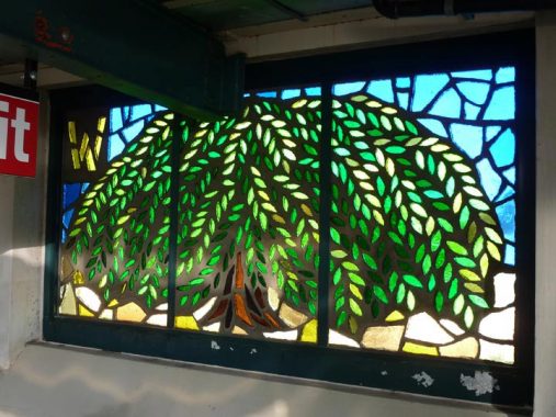
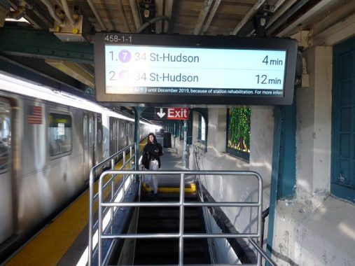
I took the #7 train to the 46th (Bliss) Street station. The #7 stations at 33rd (Rawson), 40th (Lowery) and 46th (Bliss) have the best stained-glass art of any elevated station, not only because of quality but because of theme. The windows are labeled alphabetically from A-Z with a Queens-themed scene in each window. The stained glass was created by the late artist Yumi Heo and the installation is called Q Is For Queens. The pieces celebrate their 20th anniversary in 2019. The “W” window depicts Flushing’s famed Weeping Beech tree.

This is likely the lowest-positioned “countdown clock” located in the system, making it vulnerable to attacks by the local youth. #7 clocks are younger than the ones in other IRT stations and reflect a later design.
Place names called “Bliss” in this part of town take their names from Neziah Bliss, inventor, shipbuilder and industrialist, who owned most of the land here in the 1830s and 1840s. Bliss, a protégé of Robert Fulton, was an early steamboat pioneer and owned companies in Philadelphia and Cincinnati. Settling in Manhattan in 1827, his Novelty Iron Works supplied steamboat engines for area vessels. By 1832 he had acquired acreage on both sides of Newtown Creek, in Greenpoint and what would become the southern edge of Long Island City.
Bliss laid out streets in Greenpoint to facilitate his riverside shipbuilding concern and built a turnpike connecting it with Astoria (now Franklin Street in Greenpoint, Vernon Blvd. in Queens); he also instituted ferry service with Manhattan. Though most of Bliss’ activities were in Greenpoint, he is remembered chiefly by Blissville in Queens (a small wedge of Queens positioned between Newtown Creek, Calvary Cemetery and the Queens-Midtown Expressway) and by a stop on the Flushing Line subway (#7) that bears his family name: 46th Street was originally known as Bliss Street.
Though Queens streets were numbered in the 1920s to prevent confusion caused by duplicate names in different neighborhoods (formerly independent towns before Queens joined Greater New York) new forms of confusion arose when several streets in the same neighborhood have the same number, such as the corner of 47th Street and 47th Avenue in Sunnyside. Further south in Maspeth, there’s an area where seemingly every street is numbered 60.
Here’s an unusual Art Deco building at 47-35 47th Street, where the house number doesn’t have the usual hyphen. Beautiful etched glass on the front door, and terra cotta highlights on either side of the door.
One of Sunnyside’s Cosmopolitan Houses, constructed in 1922 by Metropolitan Life Insurance and originally built for low-income families. They’re known for their singular arched brickwork at their entrances and the presence of Type B park lampposts.
Just north of the Queens-Midtown Expressway, 47th Street takes an abrupt turn and intersects with 48th (told you things could get confusing). There’s a small area of green at the side of the street that would make a decent public park, but the No Fun Bunch has prohibited everything.
Where every other word is “no”….
The west end of New Calvary Cemetery, one of the seemingly innumerable western Queens cemeteries, is visible from 48th Street north of the Queens Midtown.
What’s unusual about this street sign at 48th Street and the expressway exit? It’s one of only two signs in Queens that identify I-278 as the “Long Island Expressway.” I have the reasons for that on this FNY page.
West of 48th Street and south of the Queens Midtown we are in a mostly industrial, and only occasionally residential, region known alternately as Laurel Hill (that’s where Laurel Hill Boulevard gets its name) or West Maspeth. I give a thorough going over of Blissville and Laurel Hill on this FNY page, which also doubles as an account of my obsession with New York City street maps, especially Hagstrom.
In this view of 54th Avenue looking west, the one-story, lengthy building at left was once Hagstrom Maps headquarters, and I interviewed for a job as a researcher there in 1992 and struck out — as I had struck out in 1981 when I interviewed at their then-HQ on West 33rd Street in Manhattan, where I had previously gone on a pilgrimage in 1971 with my mother to buy some maps that I couldn’t find on stationery store racks! Told you I was obsessed.
Some of Laurel Hill’s now-sparse residences, some abandoned now, some nearly so.
I refer to Laurel Hill as being “in the shadow of Empire” because it has some spectacular views of the Empire State Building, directly in view to the west across First Calvary Cemetery. The neighborhood’s hills have not been leveled, and this is at the crest of one, at 54th Avenue and 46th Street.
Cranes Inc. has some of its goods parked in a lot on 54th Avenue and 44th Street.
When Cranes, Inc. was founded back in the Post-Depression days of 1940, it started with a fleet of Link-Belt truck cranes and serviced the metropolitan New York area. Under the stewardship of Paul Weiss, and currently Paul’s son, Larry, and grandson, Robert, today the company has expanded to become one of the major crane rental houses in the entire Northeast region. Cranes Inc.
From FNY’s Calvary Cemetery page:
In the mid-19th Century Manhattan was getting so crowded (by 1845 the island was fully built up south of about 42nd Street) that it was running out of cemetery space. The two largest cemeteries had been developed by Trinity Cemetery, in the churchyard adjacent to its ancient Broadway and Wall Street location, and uptown in the furthest reaches of civilized Manhattan territory, the wild north of 155th and Broadway.
By the 1840s Brooklyn’s largest cemeteries, Green-Wood and Most Holy Trinity, and Woodlawn in the Bronx were accepting interments; and in Staten Island there was Moravian, developed in the 1760s, and myriads of smaller cemeteries.
Queens, too, had dozens of tiny burial grounds scattered around, many dating to the mid-1600s. In 1847 the Rural Cemetery Act was passed, prohibiting any new burial grounds from being established on the island of Manhattan. Presciently anticipating the legislation, trustees of the old St. Patrick’s Cathedral on Mulberry Street in what is today known as Little Italy began buying up property in western Queens. Calvary Cemetery, named for the hill where Christ was crucified, opened in 1848. The original acreage had been nearly filled by the late 1860s, so additional surrounding acreage was later purchased to the east.
The original Calvary Cemetery, called First Calvary, lies between the Long Island Expressway (formerly Borden Avenue), Greenpoint Avenue and 37th Street, Review Avenue and Laurel Hill Boulevard. New Calvary, in three divisions, is west of 58th Street (formerly Betts Avenue) from Queens Boulevard south to 55th Avenue. Smaller, pre-existing cemeteries were part of the original acreage, and were then surrounded by Calvary.
In the above photo, The King Of All Buildings, First Calvary’s oldest mausoleum belonging to the Johnston family, and one of 57th Street’s new megaliths are prominent.
Laurel Hill Boulevard is the roadway that skirts Calvary Cemetery in its western section and since the 1950s, has been the service road for the Brooklyn-Queens Expressway, beginning at Review Avenue and running northeast to 67th Street just short of Queens Boulevard. Since the BQE was put through its cemetery section has been left alone for the most part and was missing a sidewalk in some sections.
As part of the New Kosciuszko construction, Laurel Hill Blvd. has been repaved and has been given a new pedestrian-bicycle section.
At this point it must be mentioned that Parks and Traffic czar Robert Moses, who worked with nearly unrestricted political power from the 1930s and 1960s because he was never an elected official, did not vouchsafe pedestrian, bicycle or transit access to any of his major bridge projects after the Old Kosciuszko was opened in 1939. Whatever walkways the Whitestone and K Bridges had have disappeared, while the Throg(g)s Neck and Verrazzano Bridges never had any. The Triboro (RFK) Bridge, opened in 1934, indeed has a narrow walkway that has suffered from neglect over the decades. Moses largely believed that People Who Matter drive (he himself did not drive a car, but was chauffered everywhere) and the hoi polloi walked or took public transit: and Moses believed in societal stratification.
This is a new era for pedestrian and bicycle access, and any new project under construction contains allowances for those transportation choices. However the Kosciuszko Bridge has come under fire from bicycle champions such as NYC Comptroller and mayoral candidate Scott Stringer, who says that dedicated bicycle lanes should have been part of the design. The Department of Transportation counters that such lanes will soon be constructed.
Ascending the ramp to the New K Bridge, Calvary Cemetery and the Manhattan skyline beyond are highlighted. This is the V formed by Laurel Hill Boulevard and 56th Road, which runs along the old Long Island Rail Road Montauk Branch, a former passenger line that now serves only freight.
Other NYC bridges that permit walker/bicyclist access go from “somewhere” to “somewhere.” The Brooklyn Bridge’s path connects Brooklyn’s DUMBO and Manhattan’s Civic Center, while the Manhattan Bridge connects DUMBO and the cusp of Chinatown. The George Washington Bridge connects Washington Heights and Fort Lee, New Jersey. The Triboro’s, Harlem and Astoria, with a spur connection to Port Morris, Bronx, admittedly a mostly industrial area.
Walking across the New K from Laurel Hill to Greenpoint, you pass old warehouses and factories; Cranes Inc.; as well as Holy Calvary, “where all roads lead” according to Newtown Pentacler Mitch Waxman. You pass over the noxious and noisome Newtown Creek, where chemical detritus has been deposited by various creekside concerns for over a century and the banks are lined with the remnants of former slaughterhouses and fat-rendering plants. You are deposited in the east end of Greenpoint, where steam shovels move around tons of metallic trash in recycling plants, throwing steel dust and who knows what else directly into your nostrils.
You are in Real New York.
An unfortunate aspect of the K Bridge’s new pedestrian-bicycle lane is that it is unprotected, or rather, pedestrians are unprotected from bicycles. That would be a problem if this bridge ever gets as busy as the wood-planked Brooklyn Bridge ped/bike walkway, in which speeding bikes going 20-30 MPH come close to hitting grannies wheeling prams. That problem seems unlikely for now, but walkers are entreated to be wary about any speeding bicycles appearing from nowhere.
One aspect of the old K Bridge, its brass plaques containing Polish and American eagles, have thankfully been retained for the new K Bridge. What was originally called the Meeker Avenue Bridge when it opened in 1939 was renamed the Tadeusz Kościuszko Bridge for the Polish general who aided George Washington during the American Revolution on 9/22/1940; a large Polish population in Greenpoint and Maspeth, Queens had already been well-established. In 1940, Poland was occupied by Nazi Germany.
A look from high above the LIRR Montauk tracks toward the Shining City. Remember, pedestrians have not had a similar view for many decades, if they ever did; the view is rather different from other Creek crossings such as the J.J. Byrne (Greenpoint Avenue) or Pulaski Bridge crossings.
I’ll end Part 1 midspan over Newtown Creek, rather than fall victim to the modern bloggers’ dilemma: do not create lengthy pieces that will tire out attention-span deprived readers who cry “Too Long Didn’t Read.”
In Part 2, we’ll look into Brooklyn from the K Bridge span, as well as invade parts of it that the guidebooks won’t touch.
Check out the ForgottenBook, take a look at the gift shop, and as always, “comment…as you see fit.”
9/15/19
