
The website I’ve run for 20 years, Forgotten New York, is sometimes like the NFL. I’ll explain. The NFL is divided into two conferences, the AFC and the NFC, which in turn are divided into three divisions. Your team plays the teams in its own division twice per season, and it plays the rest against teams from your own conference and against a division from the other conference, which means your team sees a team from the other conference on average, once every three years. Because of scheduling quirks, though, you might not see a team from the other division or conference for six years or even nine.
Since my lair’s in Little Neck, I see my own “division,” which I consider northern Queens, downtown and mid-Manhattan, and northern Brooklyn, quite a bit. And I think of southern Brooklyn as well as mid-Queens and southern Queens out of division, but still in conference, i.e., I see them now and then, but not as often as the neighborhoods in my own division. Bronx, northern Manhattan and Staten Island, though, are in the other conference—I see their neighborhoods not as often as that, and sometimes very rarely. Today’s explorations, in Pelham Bay, were definitely “out of conference” since the last time I walked around in Middletown and Pelham Bay in the Bronx must have been seven or eight years ago. Fortunately, nothing around here seems to change much from year to year, except encroaching bad architecture.
It’s actually rather elementary to get from northeast Queens to the northeast Bronx without a car. For other areas, the Metropolitan Transportation Authority makes interboro travel a chore or an impossibility. The MTA considers its primary directive (in my opinion) to move hardworking men and women from non-Manhattan boroughs into Manhattan in the morning, and vice versa in the evening. The Long Island Rail Road, in particular, passes through Queens but serves that borough reluctantly; it’s here to get Nassauvians and Suffolkers to the city. At the same time, you won’t find any subway lines constructed exclusively between, say, the Bronx and Queens. It’s true that the old IND Crosstown Line (today’s G train) serves only Brooklyn and Queens, but that line was built from 1933-1937 primarily to put the Myrtle Avenue El, which originally went over the Brooklyn Bridge, out of business.
I can, though, reach the Pelham Bay area pretty damn easy by taking the Q50 bus from Main Street over the Whitestone Bridge to Pelham Bay Park. Now, mind you, the MTA does make finding the bus stops for that line fairly hard to find, but they’re there.
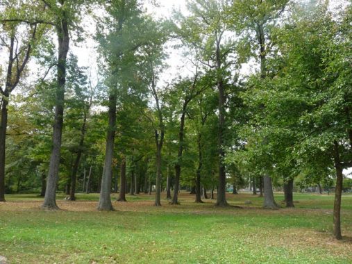
Most New Yorkers would likely immediately respond “Central Park” when asked what the largest park in New York City by acreage is. There are, however, several parks in NYC much larger. Both Van Cortlandt Park and Pelham Bay Park, in the Bronx’s northeast corner, are over double Central Park’s size.
At over 2,700 acres, that title of NYC’s largest park belongs to Pelham Bay Park, which stretches from the old Bronx neighborhood of Middletown on the south to the Westchester County line on the north, and from the Hutchinson River and its namesake Parkway on the west to Eastchester Bay and Long Island Sound in the east.
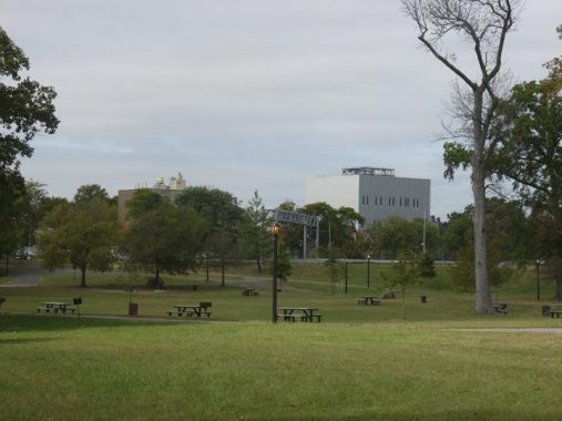
The Park contains large salt marshes, home to egrets, raccoons, blackbirds, wrens and marine life such as sticklebacks and seahorses; predators like harbor seals and ospreys (fish eagles) feast on the fish and crustaceans. On land, white tailed deer and wild turkeys have been spotted. The Kazimiroff Nature Trail, on Hunter Island (now a peninsula attached to the park by landfill) as well as the Siwanoy and Split Rock nature trails provides easy access to the park’s wilder areas. The eastern section of the park facing Long Island Sound had been named Orchard Beach as long ago as 1905 for the orchards that grew on local estates. NYC Parks Commissioner Robert Moses rebuilt Orchard Beach into its present configuration in 1936, attaching Hunter Island and creating one of NYC’s two largest parking lots (along with the one in Riis Park), and added more territory in 1947 by filling in Twin Island.
While striding across Pelham Bay Park’s verdant hills, a metallic Megalith comes to view in the distance. This stolid structure, opened in 2016, resembles Star Trek’s Borg Cube, or perhaps the Ministry of Truth from Orwell’s 1984. In fact, vital business is carried on here. You may be aware of the TV show 911, which follows the lives of emergency service workers in Los Angeles. This building, PSAC II, is where over 11 million 911 calls for the NYPD and FDNY have been fielded, joining PSAC I at MetroTech Center in Brooklyn. It’s one of the most heavily protected and secured buildings in New York City, constructed of concrete clad with silvery aluminum panels. The building is nearly windowless, but workers inside—who have a stressful task—enjoy the benefits of walls in the lobby and cafeteria lined with plants that partially serve as an air filtration system.
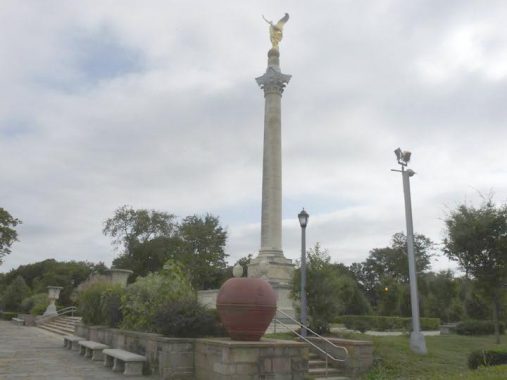


Meanwhile, another enormous structure can be seen in the park along the service road connecting the Bruckner Expressway with Shore Road, the northeast extension of Pelham Parkway. A beautifully gilded statue of “Winged Victory” tops this towering column. The Corinthian column is surrounded by a landscaped plaza and raised paved terrace in the streamlined Moderne style popular when the Memorial was designed by architect John Sheridan and sculptors Belle Kinney and Leopold Scholz in 1932. the star of the show is the brilliantly gold “Victory,” 18 feet tall and weighing more than three tons. The Memorial was renovated from base to tip in 2001 after decades of weathering and vandalism.


The Corinthian column is surrounded by a landscaped plaza and raised paved terrace in the streamlined Moderne style popular when the Memorial was designed by architect John Sheridan and sculptors Belle Kinney and Leopold Scholz in 1932. Limestone reliefs depict marching soldiers and the paths leading to the memorial are lined with lavish floral beds and hedges.
The reason for such a lavish memorial? The generic answer is “because we choose to do so.” Memorials as lavish as this, as well as architectural embellishments in general, are passé in 2019, giving way to simple glass-walled things utterly lacking in character, as equality in everything is the guideword, and no nail will be allowed to stick up lest it be hammered down.
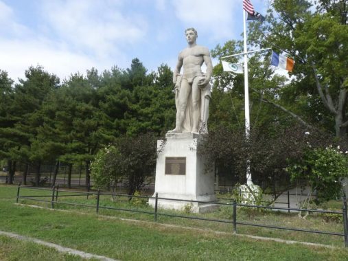
I’d heard of Pelham Bay Park’s Rice Stadium on Middletown Road facing Kennilworth Place, constructed in the early1920s and demolished in 1989. It was built with the aid of a $1 million grant from Julia Rice, the widow of musician, lawyer, publisher, chess expert, submarine pioneer, and president of the Electric Storage Battery Company, Isaac Leopold Rice. Mrs. Rice was the founder of The Society For the Suppression of Unnecessary Noise and organizer for Sane and Safe Fourth of July, both efforts I could get behind. After years of deferred maintenance, the city deemed it necessary to demolish the stadium; it was replaced by the Aileen B. Ryan Recreational Complex, named for a local assemblywoman.
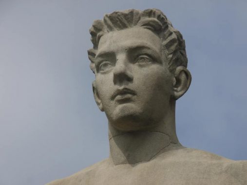
Does any trace remain of old Rice Stadium? Yes. The Louis St. Lannes limestone statue “American Boy,” installed in the Rice Stadium grandstand in 1932, was retained by the Parks Department, restored in 2002 and reinstalled in 2004.
Streets in the vicinity of Rice Stadium were laid out in the early 1920s, about the time the stadium was constructed, and many have names honoring physicists such as Ohm, Ampere, and Watt, as well as Radio, Research and Library. Recall that Isaac L. Rice was president of the Electric Storage Battery Company.
I should someday write a Forgotten NY item about streets that are named for objects no longer in existence. Stadium Avenue is one of these, named for Rice Stadium (see above). Booth Memorial Avenue in Flushing is another; named for a hospital on Main Street that decades ago became part of New York Hospital.
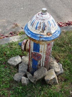
Here on Stadium Avenue, south of Watt, is what I call a Bicentennial Hydrant, one of many of NYC’s fire hydrants painted in red, white and blue, maybe some stars and stripes, in the USA’s Bicentennial year of 1976. The next big anniversary is in 2026, the 250th anniversary. I’ll have to look up what they call the 250th of anything.
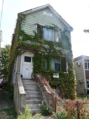
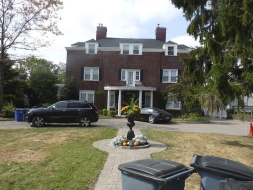
Most of the housing in the area is well kept and tidy, with the streets laid out and built from 1900-1925, but many homes built in the postwar period after 1945. This is one of the older campaigners, a fixer upper covered in ivy.
The neighborhoods immediately south of Pelham Bay Park are called Spencer Estates and further south, Country Club. In the 19th Century the Spencer family married into the tobacco-growing Lorillard family. William Spencer was a benefactor of the NY Public Library and son Lorillard Spencer was the publisher of The Illustrated American.


What’s billed as the Evers Marina and Seaplane Base can be found at the east end of Griswold and Outlook Avenues. More a marina than a seaplane base these days, it has been run by two men since its founding in the 1930s: first by Carl Evers and then by his son, Charles, now well into his 70s. It was a busy seaplane base in its early days, but since the 1960s has been a harbor for yachts and other pleasure and fishing vessels. Charles Evers still owns a seaplane of his own and takes it for a spin around Eastchester Bay now and then, and the base has been used by other seaplane enthusiasts such as Jimmy Buffett.


A sampler of homes along Griswold Avenue between Outlook and Stadium Avenues. The homes on the south side of the street actually face an inlet as I will show a bit later. The street is named for Griswold Lorillard, of the tobacco-producing family that owned a great deal of Bronx territory in the past.


You notice the waterfront as you walk along Griswold, but the water views are vouchsafed only to those who own the properties bordering the inlet. While waterfronts are being opened to the public elsewhere around town, the prevailing theme here seems to be that the nearby Orchard Beach and City Island waterfronts are sufficient. Palmer Inlet, a little-known arm of Eastchester Bay, can be seen here along with several water-facing homes along Griswold Avenue.
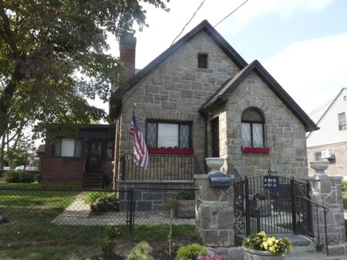
On Stadium Avenue you see a lot of Tudor-esque cottages…
However there are some larger estates on larger plots such as 1345 Stadium Avenue, between Country Club Road and Polo Place; indeed, the land here was formerly occupied by the Westchester Country Club, when this part of the Bronx was part of Westchester County (which it was until 1895). Yes, there were yachts, polo ponies, and other pursuits of the Idle Rich. (If I ever stumbled into some money, would I want to pour it into yachts and polo ponies? Maybe it’s automatic.)


NYC is marked by clusters of streets with a theme-based naming scheme. Many of the northeast Bronx streets are named for early NYC mayors beginning in the 1600s; Brooklyn Heights has a fruit tree scheme; Staten Island has classical composers in Clifton and astronauts in New Springville. In the Bronx’s Spencer Estates, just south of the Isaac L. Rice-inspired electronics street theme, there’s a cluster of streets such as Parsifal Place that are named for characters or place names in Wagner operas or Wagner family members, including Lohengrin, Valhalla, and Siegfried. This was apparently the idea of Eugene Rosenquist, president of the Westchester Electric Light Company, who owned the estate in the area through which these streets run.
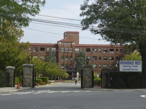
The Sisters of St. Joseph run a large nursing home called Providence Rest at Stadium Avenue and Waterbury Avenue. Like firehouses and some churches, the online historical details of the place and nonexistent or sketchy; I’d love to know when the place was built, and if it had an original purpose. Comments, anyone?
Waterbury Avenue is unusual — it begins at Westchester Avenue in Castle Hill and is in three separate Bronx neighborhoods including Middletown and Country Club, interrupted by Westchester Cerrk and the Bruckner Expressway. I used it to wander west toward my designated lunch spot.


One of the quiet side streets here is called Throgmorton Avenue, so named in 1916 to honor the founder of the Throg(g)s Neck community, John Throckmorton, a Britisher given permission by the Dutch government then in charge to settle on the southeastern end of what would become the Bronx in 1642. The name became altered in spelling over the years (I’ve even seen “Frog’s Neck” on some documents) and though the name is spelled Throgs Neck on maps and highway signage, most residents add an extra G so it becomes Throggs Neck.
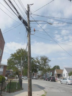
I can be forgiven for enjoying the sight of this very busy telephone pole on Waterbury between Throgmorton and Ellsworth, carrying telephone and power lines as well as a finned streetlamp mast and a J-shaped pipe with a now-decommissioned orange fire alarm indicator lamp. Why was it placed here? The actual alarm is mounted on a pole at Waterbury and Ellsworth, and the indicator should have been placed there; it’s all moot now.


Crossing the Bruckner Expressway over a pedestrian overpass, I encountered the First Lutheran Church od Throggs Neck, as it’s spelled in the neighborhood. The congregation was founded in 1922, with the current building at Baisley and Hollywood Avenues in 1943.


In 2019 Louie & Ernie’s Pizzeria celebrated 60 years in the business at Baisley and Waterbury Avenues. Founder Ernie Ottuso was honored by having the intersection named for him several years ago, and the original blue and white honorific sign is still in place. All Bronx streets were signed with vinyl blue and white signs between 1964 and 1984.
Whenever I’m in these parts I get a slice here. In Serious Eats, Adam Kuban explains that Ottuso sold the pizzeria to brothers Cosimo and Johnny Tiso in 1987. “As Cosimo Tiso says, ‘We just make pizza. We don’t make sandwiches, we don’t make salads.'” The pizzeria has been here in what appears to be a private home that has been converted to a pizza place for several decades.


I have always had a fascination with B Street, a dead end on Baisley between Crosby and Edison Avenues. After all, there are no A or C Streets. Or were there?
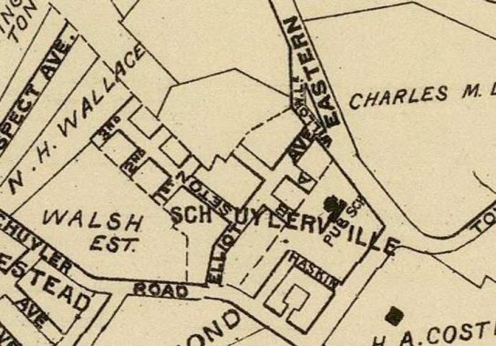
On this Hyde map, circa 1910, many of the streets shown are still in existence, but with different names; Fort Schuyler Rd. is Tremont Ave., Eastern Blvd. is Bruckner Blvd., and Elliott is Baisley. And, as it turns out that the dead end now a piece of Hobart Ave., was formerly A Street, which makes the presence of a B Street more logical. The roads marked Seton and Haskin have disappeared off the map. According to Bronx historian John McNamara, A Street went through a period as Amsterdam Ave. before becoming a dead-end extension of Hobart Avenue, which otherwise runs between Baisley and Zulette Avenues and further north, between Middletown Road and Continental Avenue. A numbered sequence, 1st, 2nd and 3rd, are long gone.
Another “B” I can’t explain is Port Richmond Staten Island’s Avenue B, which doesn’t seem to ever have had an accompanying Avenue A or C. Me, I always got an A in geography instead of a B—in grade school.


Crossing the Bruckner Expressway again, via the Crosby Avenue overpass. This is one of the last strongholds of the highway-strength double mast Donald Deskey lampposts. Midway across the span, Crosby Avenue becomes Logan Avenue.
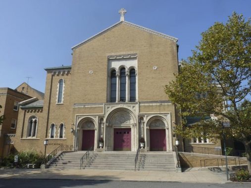


St. Benedict Church’s parish was established in 1923 on Eastern Boulevard (later renamed Bruckner Boulevard) in a pair of frame buildings. The current brick church was dedicated in 1958. In 1923 the only other Catholic church in the area was St. Raymond’s, a couple of miles away in Westchester Square. Terence James Cardinal Cooke (1921-1983) lived in the area and attended the parish school. He is remembered by a plaque at the church door at Otis Avenue and by a street sign on Bruckner.
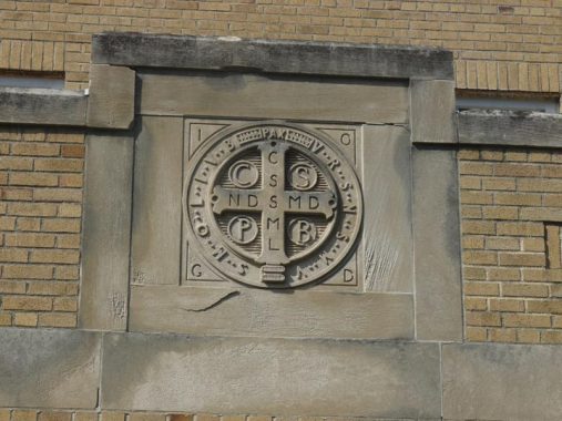
At first I was perplexed by this symbol that appears on both the Logan and Otis Avenue sides. After inquiring around I discovered it is a depiction of the Medal of St. Benedict; the letters are all the initials of Latin words. This wikipedia page has a description and explanation.


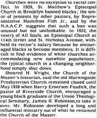
This is the unusually-named Church of the Master at Lafayette and Swinton Avenues. The original church was founded in Morningside Heights in 1938 as an outgrowth of the Morninsgide Presbyterian Church, as the late Christopher Grey explains in a 1994 New York Times article:


Two vast cemeteries are associated with St. Raymond’s Church in Westchester Square and are operated by the Catholic Diocese of New York. Old St. Raymond’s, located roughly between Waterbury Avenue, Bruckner Expressway, the Hutchinson River Parkway and East Tremont Avenue, was originally the “Underhill Farm of Throgg’s Neck” purchased by Rev. Michael B. McEvoy who was pastor from 1875 to 1885. Old St. Raymond’s Cemetery was started in 1875.
The church purchased additional property in the early 1950s to create New St. Raymond’s, seen here, between the Hutch, Cross Bronx Expressway, and Randall and Lafayette Avenues. New St. Raymond’s is the final resting place of boxer Hector “Macho” Camacho, pop’s Frankie Lymon, actress Lois Nettleton, salsa’s “La Lupe” Yoli and jazz songstress Billie Holliday.
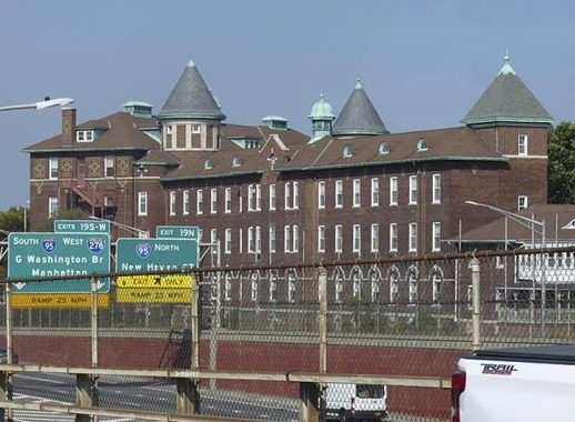
Time to get on the bus over the Whitestone back to Queens. There are a pair of forbidding-looking brick buildings in view from Lafayette Avenue and the Hutchinson River Parkway; one is Monsignor Scanlan High School, and this one is the St. Joseph School of the Deaf, founded in Fordham in 1869 with this “new” building dedicated in 1913.
Check out the ForgottenBook, take a look at the gift shop, and as always, “comment…as you see fit.”
12/15/19
16 comments
Think you mean the Q50 bus, not BX100. It was originally called QBX1 and was started in 1970 by Queens Transit Corp. That firm, later renamed Queens Surface Corp., became part of MTA Bus Company in 2005.
Despite the fact that I was born & raised in the Parkchester section of the Bronx (I lived there 1949-72) I didn’t know that there was a street named Ellsworth nearby. When I relocated to AZ in 2005 I encountered Ellsworth Rd in what was then the remote village of Queen Creek. It was named for rancher Dwayne Ellsworth, who passed away six days after my arrival, I just found out. Over the next ten years Queen Creek transformed itself into a growing suburb. Here’s more information:
https://www.eastvalleytribune.com/local/queen_creek/pioneer-rancher-duane-ellsworth-dies-at-q-c-home/article_11a13fde-dce9-52cb-be8c-ecb4fd5d1ac9.html
BTW: In 2005 the place where I settled was called Queen Creek for lack of any other name; it was over the Maricopa Co line in Pinal Co. Eventually there was a plebiscite & the name San Tan Valley was chosen to distinguish us, Here’s a map:
https://www.bing.com/maps?q=Ellsworth+Rd%2C+Queen+Creek%2C+AZ&form=PRUSEN&mkt=en-us&httpsmsn=1&msnews=1&rec_search=1&refig=5d41347cef714a21b146f6678152c6cf&sp=-1&pq=ellsworth+rd%2C+queen+creek%2C+az&sc=8-29&qs=n&sk=&cvid=5d41347cef714a21b146f6678152c6cf
The area is growing, probably at the same rate as the Outer Boroughs of NYC were after WW2.
Really wish Parks Department would open the former Pelham Bay Landfill for public access. If anyone knows what the hang up is, please shout out.
Per a meeting two months ago, there’s still A LOT going on that needs to be done before it can get opened for public use: necessary seawall work(to start next summer), more pollutant reductions, EPA approval, etc. It’s looking at a 2024 opening at the earliest
It’s there and it looks like it’s OK to use…but looks are deceiving. They already lost one lawsuit against them regarding the site, they aren’t about to open it up until the site is stringently safe and won’t get them sued
Thanks!
Good to see that you get out of conference every now and then to do your usual comprehensive coverage of a Bronx subject. The Winged Victory monument in Pelham Bay Park once had an array of Linden trees planted in the area in front of the monument. The trees were arranged in a matrix of rows and columns to represent a military formation. Linden trees are not as sturdy or long lived as oak trees. Time, storms and disease have taken a heavy toll and today few of the old trees remain. Also, the monument was once (may still be) a favored destination in warm weather for wedding parties to have wedding pictures taken. I often wondered what motivated the choice of that location. Was it the brides desire to commemorate her victory? Or was it the wedding photographer’s sly sense of humor that prompted him to take his pictures where the background included a naked lady dancing upon the knob on the end of a gigantic phallic symbol?
Not all 911 facilities are quite as elaborate as PSAC II. There’s a fairly well-known 2013 case involving a man named Brandon Lawson, who disappeared in a rural part of Texas after making a bizarre 911 call. One thing that came out in the investigation is that Coke County, with a population of 3,000, is too small and has too little 911 activity to justify a dedicated call center. Instead, 911 calls go to a special line at a local nursing home, where some of the staff members have been trained to handle 911 calls. This apparently is not unusual in rural areas.
A lot of places it’s unneeded and you only need one person for fire/police/ems call taking and dispatch, places like that might have been grant recipients where they used the money to “upgrade” but in reality it was unneeded and unnecessary and only a political move.
But you can’t knock them for what is going on there: it’s no different than calling 911 from a cellphone in a lot of places. In Massachusetts for instance, your call doesn’t go directly to the local department- it goes to the State Police who then transfers it to the local department for a response.
i remember painting hydrants in a patriotic scheme as part of a fellow boy scout’s eagle project as a kid. i t didn’t make sense to me then as to why someone thought it was appropriate to paint an object whose primary function is a dog urinal with an american flag theme. it still doesn’t make sense to me now.
Some years back I toured the Suffolk County NY 911 center. It’s in the basement of a county building in Yaphank and when I was there, I don’t remember what time of day, there were about 15 to 20 people on duty. One thing I recall is that some of them take police calls and the others fire/medical calls. Those who do fire/medical calls have more training because they sometimes have to talk callers through performing CPR or other measures. I can imagine it’s a tough job, especially as in some places, NYC for sure, you have to deal with people who may speak little or no English.
As for Brandon Lawson, the likely explanation is that he overdose after making the weird 911 call. As for why careful searches never found his body, well, that part of rural Texas is infested with feral hogs, and they eat _anything_.
Interesting seeing PSCAC II, it’s a place that’s nice to look at even if it sticks out like a sore thumb.
There is one big mistake in the article: the NFL split into four divisions in 2002 when the league expanded to 32 teams. Teams now face each other once every four years instead of every three years.
sestercentennial (or the semiquincentennial
When Princeton University had its 250th anniversary in 1996, they called it the Bicenquinquagenary. Pronunciation is left as an exercise for the reader, I don’t think I ever got it right. I empbasized QUAG with a minor emphasis on BI, others emphasized alternate syllables: BIcenQUINquaGENary.
The NFL has had four divisions per conference since 2002 and teams play opponents from the other conference once every four years and teams from the other divisions of its own conference at least once every three years. There is never a situation where a team does not play another team for six or nine years and hasn’t been since the 2002 realignment.
I grew up on Gillespie Ave. – between Zulette Ave. & Middletown Rd. Would like to know the origin of “Gillespie” Ave.!
A surveying engineer who helped lay out the street.