
As a boy, I took the B63 bus on 5th Avenue with my mother, father, or both, to some downtown Brooklyn destination. Or, sometimes we just took rides, as I enjoyed riding the bus, looking out the window at all the signage and lampposts. During that time the Great Mercury Shift was happening as incandescent streetlights, often mounted on ornate castiron poles, were being changed out for soft greenish-white mercury lamps on new octagonal-shafted poles.
I then took the B63 to high school (I could have taken the R(R) train, but you can’t see anything out the window and couldn’t transfer to the B45 bus) and then college, so I was a regular B63 rider from age 6 all the way to age 22! (Sometimes, I’d use the B37 on 3rd Avenue, for different views.)
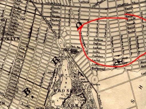
As the 5th Avenue bus neared Flatbush Avenue, I noticed something odd about the street layout. There was a changing of the guard from one street name to the other. At 5th Avenue, Warren Street, Baltic Street, Butler Street, Douglass Street, DeGraw Street and Sackett Street all changed their names and became Places: Prospect, Park, Sterling, St. Johns, Lincoln, and Berkeley. That in itself is odd, as in NYC, the “Place” street designation usually refers to streets that go one or two blocks only. However, these “Places” go on and on, dozens of blocks east to the Bedford-Stuyvesant-Brownsville border at East New York Avenue. There’s an exception, which I’ll get into.
If you look at an 1855 map of what had been the City of Brooklyn at the time, you see, though, that the Butler, Baltic, Douglas(s), Degraw, and Sackett names did indeed extend all the way east into Bedford-Stuyvesant. Only later did they became Places.
What happened? Murder happened.
On March 20, 1873, Lizzie Lloyd King, a.k.a. Kate Stoddard, shot dead her boyfriend, Charles Goodrich, who wished to break off the relationship, at 731 Degraw, just west of 5th Avenue (the address has been renumbered since) . She fled with several of Goodrich’s possessions before returning the next day to clean and dress the corpse before going to her job at a hat factory. Just another day in Park Slope. After a three-month investigation, aided by Stoddard’s friend Mary Handley, the murderer was apprehended and sentenced to the State Lunatic Asylum in Auburn, NY; the building still stands. A 2013 play by Claudia Barnett examined the murder in the context of the works of Emily Dickinson.
Real estate values in the area dropped as a result of the murder. As a result, the decision was made to change Degraw Street’s name, and the other parallel streets in the area followed suit between 1874 and 1881. Warren and Baltic became “Prospect” and “Park,” a bit clever, for nearby Prospect Park; Butler, “Sterling Place’ for William Alexander, Lord Stirling, who led the patriots in the Revolutionary battle at the Old Stone House; Douglass (the name isn’t connected with abolitionist and orator Frederick Douglass) became St. John’s Place, for St. John’s Episcopal Church, built in 1870 on Douglass in 1870; Degraw became Lincoln Place, for Abraham Lincoln; and Sackett became Berkeley Place, for Irish philosopher and Anglican minster George Berkeley (1685-1753), for whom Berkeley, CA is also named.
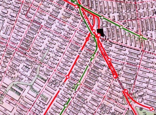
Meanwhile, Wyckoff Street becomes St. Marks Place at 3rd Avenue and then, St. Mark’s Avenue at 5th Avenue. The name puzzles me, since the nearest St, Mark’s Church is the Episcopal church at Brooklyn Avenue and Union Street in Crown Heights.
In the 1870s, Sackett Street was eliminated east of Grand Army Plaza so that Eastern Parkway could be constructed.
Only the Sacket-Berkeley and Degraw-Lincoln combinations are truly continuous. The other streets require a slight jog on 5th Avenue, as here at Douglass and 5th, with St. John’s Place continuing beyond. There is no Butler-Sterling continuation, as a supermarket was constructed in Butler street’s roadbed in the 1980s.
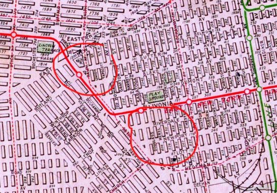
Douglass Street is the wild card in the pack. Take a look at this 1922 Hagstrom map excerpt. In it I have circled Union Street and Douglass Street in red. At East New York Avenue, each street took a strange abrupt right turn, heading south into Brownsville. This “goes against the grain” of how streets are generally laid out in New York City.
It also split Douglass Street into two separate sections, miles apart, when the portion of Douglass between 5th and East New York Avenue was renamed St. John’s Place. However, in the 1920s, the orphaned section of Douglass was renamed for former Congressman, businessman and philanthropist Isidor Strauss, who co owned both Macy’s and Abraham and Strauss (A&S) department stores, who went down with the Titanic with his wife Ida on 4/15/1912. The weird southern jog of Union Street is still there.
Check out the ForgottenBook, take a look at the gift shop, and as always, “comment…as you see fit.”
4/16/20
16 comments
Park Slope? Please. The neighborhood at the time was South Brooklyn. A grand old neighborhood. It wasn’t until the 1960s and 1970s that Park Slope began it’s westward creep.
Didn’t Gowanus extend to 5th back then?
Thanks for another informative article. Speaking of interrupted streets, please comment on why Ralph Ave. has two sections.
Assuming it was once a continuous street, why was the street grid created between East 98th St. and Remsen Ave. to
interfere with the adjacent grids? Did it have anything to do with the jurisdictions of the Town of Flatbush and the Town of
Flatlands before they were annexed by the City of Brooklyn?
It was laid out like that, even in 1890, that grid was in place even though the streets weren’t built yet.
http://www.historicmapworks.com/Map/US/1600/Index+Map/Kings+County+1890/New+York/
Ralph Avenue is named for early Kings County figure Ralph Patchen; there is also a Patchen Avenue.
How about one section for Ralph Patchen & the other for Ralph Kramden?
I’m sure thats true…..but I can’t help seeing Mr. Kramden in my mind whenever I think about Ralph Avenue in Brooklyn!
Two more that had been changed at an earlier date:
Bristol Street was formerly part of Baltic Street. In January 1887 the New Lots Board of Trade recommended to the Common Council the renaming of 67 streets in the former Town of New Lots, with the proposed names having the same initial letter as the original name. The name recommended for Baltic Street was Burton Street; the council selected Bristol Street. Renamed by Common Council on April 11, 1887, effective April 26, 1887.
Legion Street: Once part of Degraw Street. Renamed as Barrett Street by Common Council on April 11, 1887, effective April 26, 1887. Became Legion Street circa 1937.
Interesting since Bristol extends as far south as Avenue D, one of the streets of the Flatbush street naming system.
Titanic went down in 1912, not 1915.
In the 1855 map, were those streets really laid out yet east of Flatbush Ave.? I thought they weren’t built until Civil War 1860’s. Can someone verify? My great grandparents moved to the corner of Classon and Butler about 1870.
Looking at the 1855 Map is a circle at approx Washington & Malbone (Empire Blvd) and below noted an ENTRANCE (to Prospect Park?). The Park was actually west of
Flatbush where Ocean Avenue begins. Also odd that Franklin Avenue extends further south. Franklin and Washington Avenues angles have them almost meet at Empire Blvd. I worked at Washington & Empire Blvd there about 20 years.
Late to this party, but there was St. Mark’s Episcopal Church at 232 Adelphi Street (later Carlton Mews Church, now apartments), that seems to have been only a few blocks from St. Mark’s Ave.
As a young child, I lived at 22 Douglass Street (until age seven). I wish that I could see the inside of the building. I seem to remember a beautiful marble fountain in the curve of the staircase, maybe on the second floor. It had no water running through it, just beautiful, ornate marble.
Does anyone who has ever lived or lives in any of the homes on that street remember such a thing?
A while back I was doing some ancestry search and came across my grandfather’s family who live at 667 Douglass during the 1880 US census. I know the numbers have changed since then – so I am wondering where 66? Douglass would have been back then? Grandpa’s parents were Germans, father from Baden-Baden who I later found out
came to US around 1859, and mother Brooklyn born, of parents from Baden-Baden (which was its own kingdom at the time they all emigrated). I am guessing the house number at the time would have been on the Park Slope side of St. John Pl. close to that Episcopal church.
I remember my grandparents living a block from Douglas Pool. The used to live above the restaurant. I found a link to the building story. The white spots on the sidewalk are from the foot prints my father made being filled in with cement. https://lostnewyorkcity.blogspot.com/2009/05/mystery-on-nevins-and-sackett.html
So was Strauss street use to be called Douglas street ?