

I have been looking over a topographical map of sections of Brooklyn and Queens published in 1898 by the United States Geological Survey: topography by the US Coast and Geodetic Survey, H.M. Wilson, “geographer in charge.” Maps of varying ages, from 1889 to the present, can be downloaded at this link. I’m fascinated by these maps, which were ostensibly produced to show geologic and topographical conditions such as hills, inclines, depths, etc. and when it came to showing exact street layouts, they didn’t fool around.
Most of the paper maps you used to purchase in bookstores, gas stations, stationers, etc. and produced by Rand McNally, Hagstrom, etc. were very reliable. But they had weaknesses. Depending on the years they were produced, in the more undeveloped areas they showed streets and street layouts that city planners and developers had in mind. In some cases the depicted streets weren’t built until 30-50 years after the maps first depicted them! Hagstom maps of the 1960s and 1970s were notorious about this, showing a developed street grid in southwest Staten Island, only a few of which streets (most of them the main routes) had yet been built.
Not so with these USGS maps, as we’ll see. However, these maps also had weaknesses. They were not produced as street guides and hence, entire boroughs were not depicted; in the one I’m showing today, western Brooklyn and eastern Queens were left out.
Basically, what you’ll see here is the street layout as it was in 1898, the very year that Greater New York came into being and Brooklyn joined NYC, albeit reluctantly. What developers had in mind is not shown! Today I’ll concentrate on Brooklyn, and I’ll discuss the USGS Queens map in a later post.
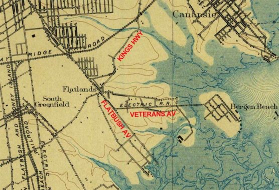
East Flatbush and Bergen Beach
In 1898 most of southeast Brooklyn was yet to be populated with housing and farms still dotted the territory, with a few roads here and there. Flatbush Avenue had been straightened and opened from an old colonial-era road, and while Kings Highway cut across the region it was a narrow farm lane and not the wide behemoth it is today. In 1898, Bergen Beach was on an “island” surrounded by swamps, but the settlement was connected to Flatbush by a trolley line running on what was fittingly called Island Avenue but today is called Veterans Avenue. In addition, some of the diagonal roads of South Greenfield are still there today.
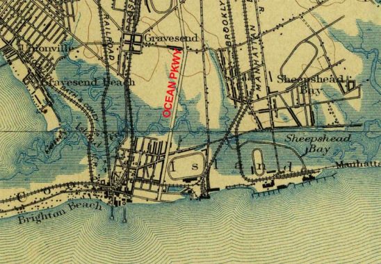
Coney Island, Gravesend and Sheepshead Bay
Coney was indeed still an island in 1898, separated from the rest of Brooklyn by Coney Island Creek, which flowed into Sheepshead Bay. Ocean Parkway had opened in the 1870s, but the best way to get to Coney was still by the Sea Beach, West End and Brighton steam railroad lines, which have all evolved into modern-day subway lines. Much of today’s Bath Beach and Coney Island is on landfill, with waterways seeping far into what is now solid ground.
The area used to be dotted with racetracks; all had disappeared by 1910, but they’re all shown here. The central square of Gravesend has been in existence since the 1690s, and it is still in place today.
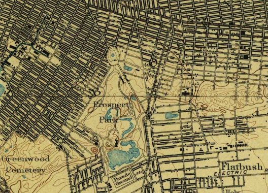
Park Slope, Lefferts Gardens, Flatbush
While much has changed since 1898 in southern Brooklyn, things stabilized much earlier the further north you went. The actual City of Brooklyn was located from about the center of this map to the top; it had annexed the other sections of Kings County by 1895. The dark lines indicate methods of pavement: the streets with the thickest, darkest lines had been macadamized while thinner lines indicated roads that were still dirt. Green-Wood Cemetery was established in 1838, with Prospect Park designed and built in the 1870s. As you can see Grand Army Plaza, at the north end of the park, was already in place. The Gowanus Canal, on the left side of the map, had already been dredged and straightened by Edwin Litchfield.
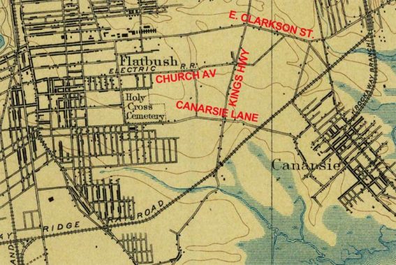
Flatbush and Canarsie
Canarsie was one of the most isolated sections of Kings County until the early 20th Century, with a couple of roads and a railroad (today’s L train) approaching it from the north. In fact your best bet to get there may have been by boat. Only the country road Canarsie Lane connected it to Flatbush; today, only bits of it still exist. Another road, East Clarkson Street, a colonial-era road that came to be named for an eastern extension of Clarkson Avenue, connected Flatbush and New Lots, today’s East New York. Kings Highway was in place, but it was merely a one-lane dirt farm road.
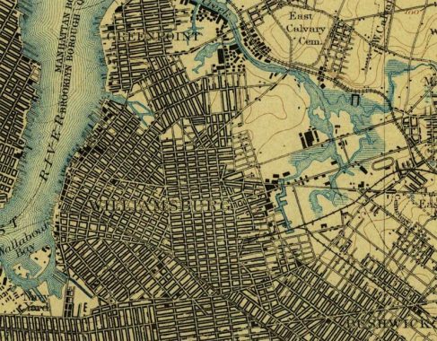
Williamsburg and Greenpoint
Much of the street layout of these realms is still in place today; both were well-established by 1860 or so. The areas near Newtown Creek remained undeveloped and indeed much of the Creek hadn’t yet been dredged and straightened. Heavy industry was already appearing on its banks, fouling the creek with effluvium that persists to this day.
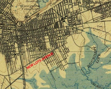
East New York
East New York emerged from the old Town of New Lots. It was hoped that it could become another major city and seaport along Jamaica Bay (there had been grand plans to dredge and deepen it) but that didn’t happen, but the hopeful name persisted.
As you can see most of the territory south of today’s New Lots Avenue was swampland and had to be landfilled to support today’s industrial areas as well as Starrett City and other housing developments. The boundary of Queens and Brooklyn was formerly Spring Creek until the creek was placed in a sewer and the boundary redrawn along the new street grid that was built in the 20th Century.
Look closely, and you can see the underground water conduit leading from Ridgewood Reservoir. The conduit, of course, inspired Conduit Boulevard in Brooklyn and North and South Conduit Avenues in Queens.
In 1898, massive Linden Boulevard was not yet even a twinkle in city planners’ imaginations.
Check out the ForgottenBook, take a look at the gift shop, and as always, “comment…as you see fit.”
1/25/21
7 comments
Paerdegat Basin is unusually straight and of mostly uniform width because the city dredged it out as part of the Jamaica Bay seaport plan. Ships would dock along its banks, which would be served by new Long Island Rail Road branches.
At least, that’s the story. While there’s no question that the city dredged the basin, it did so mainly to get landfill to use elsewhere along the bay. Dredging took place in many other areas as well. While the seaport plans poked around for many years nothing of substance ever happened.
I used to have a hard copy of this map but I carelessly threw it out during a house move. Fortunately it is on-line. This map as well as the 1852 Queens map (featured often on this website) are two of the best maps I have seen documenting the long-ago past.
On a related note, the NY Times just had an article on what is was like to number the streets in Brooklyn for the first time, and they claimed that it was sort of a disaster.
https://www.nytimes.com/interactive/2021/01/27/nyregion/brooklyn-streets-numbers-renaming.html
The thicker line along streets represents a row of buildings. The level of detail is remarkable. So many blocks are shown partly built up, based on what was there on the date of the survey.
“All the railroads shown in the map carried passengers, but today they’re freight lines, with the exception of the north-south Brighton Line”.
Huh? Only the Bay Ridge branch is still freight. Everything else is passenger or subway, or has disappeared. The end of the Canarsie line is gone. The LIRR that ran parallel to the Brighton line is gone. The West End, Sea Beach, and Culver lines, as well as Brighton, are subway lines. The LIRR along Atlantic Ave is passenger. Art Huneke’s site Arrts Archives covers a lot of this.
You got me. Fixed.
Hi Kevin, I was reading your piece on Canarsie Market today which linked back to this piece. I’m interested in finding out all I can on the Whittaker Hotel, great gramps Capt. John Whittaker, which apparently was on or near the western shore of Canarsie Point. I’ve had some luck with BHS. Do you any tips on other places to look. Thanks Brian Whittaker.