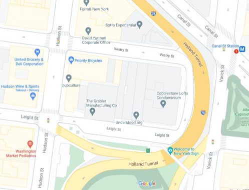

Take a look at this Google map excerpt in Tribeca, specifically, a short street wedged along a Holland Tunnel exit ramp that connects Laight and Vestry Streets east of Hudson Street. The map doesn’t identify it, but Street View, if you click on it, gives it as Varick, as does Open Street Map. I’m perplexed by this, since Varick is on the east side of the tunnel approaches, and this is on the west side. The short street itself is Belgian-blocked, as is both Laight and Vestry, which most likely indicates it hasn’t been repaved for many years. The Holland Tunnel was built in the mid-1920s, and this may have been the western end of a once-wider Varick; the tunnel approaches have been reconfigured a number of times over the years.

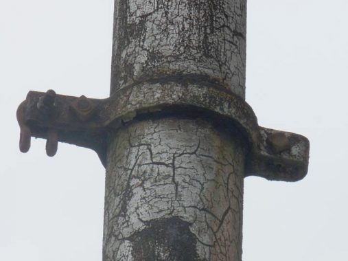
But the wider abiding mystery is the presence of a thick, rusted pole. It has some very short crossbars, which indicates it once carried wires of some kind…but what wires? Telephone wires were banished underground after the Blizzard of 1888. Trolley wire? Equally unlikely, as Manhattan trolleys were also served by underground wires unlike the outer boroughs where trolleys ran on overhead catenary wire; some of the supporting iron poles are still scattered around if you know where to look for them.
So was this a part of Varick? And what function did the pole have? The floor is open in Comments.
I earn a small payment when you click on any ad on the site.
5/10/21


16 comments
It’s Vestry Street. Vesey Street is located almost 17 blocks south.
Correct; easy to mix up all the V streets
Indeed a mystery. An insurance map from 1911 shows no street here: https://digitalcollections.nypl.org/items/510d47e2-08f8-a3d9-e040-e00a18064a99 . The same with a 1921 aerial survey: https://www.loc.gov/resource/g3804n.ct003447/?r=0.11,0.121,0.034,0.019,0 . What’s intriguing is the presence of the huge freight rail terminal immediately to the south between Laight and Beach. By 1950 it had been demolished and replaced by a parking lot. http://maps.nyc.gov/doitt/nycitymap/?z=6&p=981118,197917&c=GIS1951 The buildings on the west side of Varick between Vestry and Laight had also been removed and replaced with the paved street seen in your photo and on maps presumably during the construction of the tunnel. So this mystery pole would have to have been placed there purposely in the 1920’s for some reason. Perhaps related to the construction of the tunnel and never removed.
It may have had a sign on it
I watched this “sorta” documentary after I read this page. It might help clarify matters for you & remind you of Lower Manhattan before gentrification
https://www.bing.com/videos/search?q=news+from+home+1977&qpvt=news+from+home+1977&FORM=VDRE
:
BTW:
https://en.wikipedia.org/wiki/News_from_Home
Oh yes! I watched this when I was at LaGuardia doing my AA in film!
It looks it may been a support post for for a span-wire set-up of overhead signage for the exit roadway of the Holland Tunnel. The other post was probably located opposite side in the space between Varick Street and the Tunnel exit. Definitely not a street lamp or traffic signal support since there seems to be no electrical connection remnants
Are there three Riverside Drives at one point around 125th st? I’m sure there are other examples. Seems perfectly possible in a place like NYC to have two Varicks.
I doubt this solves the mystery completely, but this circa 1940 Municipal Archives photo shows, I believe, the pole in question: Mystery Varick Street pole. It would be the middle pole of the three in the photo. As you can see it’s supporting various signage. That’s circa 1940 however. I think I’d agree with Mr. Lagana that before that use it likely held a road-width sign over the Holland Tunnel access with a similar pole on the “old” Varick Street side, the sign being held between the two crossbars. Perhaps it had to be taken down because it became too low to allow truck traffic to get under it. The modern signs over the road appear to be at least a few feet higher as I see them on Google’s Street Viw.
Not sure the Municipal Archives link worked in the above, so I’ll try it again. Apologies if it does work and this duplicates it: Mystery Varick Street pole.
Interesting, I imagine Varick was wider at that point, or a section was built when the tunnel was opened. Interesting that Belgian blocks were used as late as the mid 1920s.
It’s not that Varick Street was wider at that point, but, as V. Hohauser pointed, out there were properties that fronted on the Varick Street that existed at the time that were acquired, condemned and/or taken by eminent domain. This resulted in about 62 feet of newly open space/new potential road. It would seem that some of the land these properties were on became the “new” Varick Street and some became part of the Holland Tunnel egress road..
To me, it resembles the trolley poles on Surf avenue in Coney Island. FWIW
The Google map I have has it tagged as Vestry St.
Ken is 100% correct. Here are some high res photo scans from the municipal archives of this pole in 1930 and 1939. Holding the cables that held the signs: Imgur Album